• About The Project
  • Palestine in Century
  • Selected Maps
  • Glossary
  • About ARIJ
  • About LRC
  • By Year
    • Case Studies By Year
    • Daily Report By Year
Friday, October 3, 2025
POICA
No Result
View All Result
  • Home
  • Settlements
    • New Israeli Settlements
    • Settlement Expansion
  • Israeli Violations
    • Agriculture
    • Confiscation
    • Demolition
    • Environment
    • Eviction of Palestinians
    • Settlers Attacks
  • Bypass Roads
  • Israeli Plans
  • Segregation
    • Checkpoints
    • Closure
    • Separation Plans
  • Military Orders
  • Reports
    • Daily Report
    • Monthly Report
    • Quarterly Report
No Result
View All Result
POICA
No Result
View All Result

Az Zawiya village lands under unlawful confiscation attack by the Israeli Occupation

March 2, 2017
in Military Orders
Az Zawiya village lands under unlawful confiscation attack by the Israeli Occupation

Location, population and area:

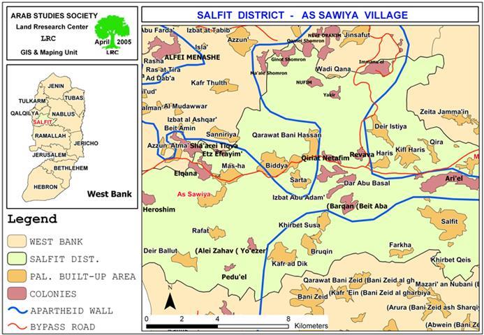
The village of Az Zawiya is located 15 km to the west of Salfit city in Salfit governorate.  It has a population of about 4000 people, mostly dependent on agriculture and animal breeding as main source of income.  The village's remaining area is 12669.5 dunums as it lost thousands of dunums to Israel during the 1948 war. Of the afore-mentioned area, 906.6 dunums are occupied by the built-up area. See map 1 & 2: location of Az Zawiya & : location of Az Zawiya


Latest violation:

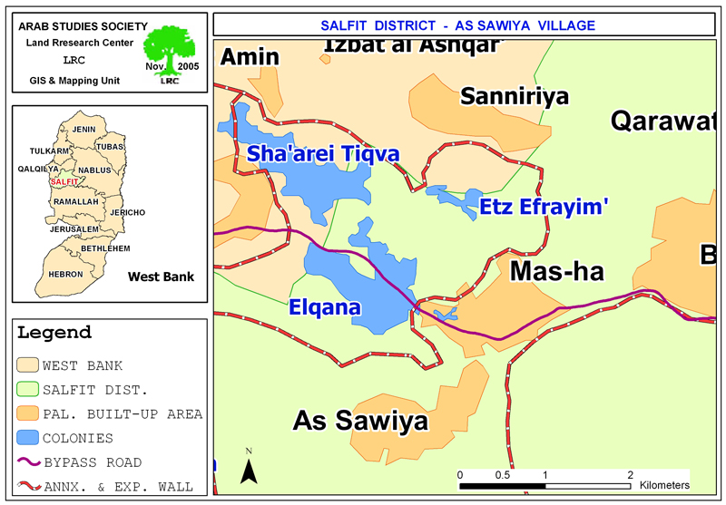
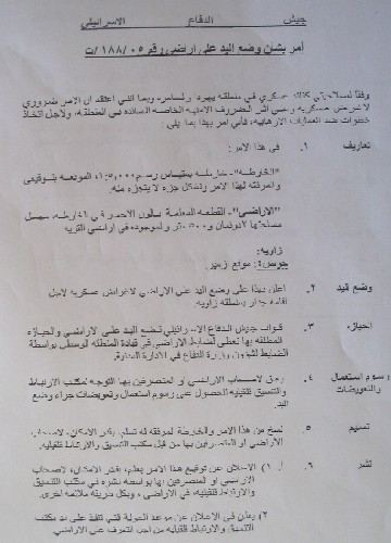
As a continuation to its expansionist policy under the pretext of security, the Israeli occupation forces issued a new military order stating the confiscation of 2.5 dunums (equal to 2500 square meters) from the lands of Az Zawiya village in Salfit governorate. Military order number (T/188/05) says that the targeted land which is located in basin 4, Az Zameer location, to the north of the village will be confiscated for the erection of the Segregation Wall and a buffer zone along the Trans-Samaria bypass road. This bypass road was established at the beginning of the Nineties with the aim of cutting the West bank into two parts and linking all the settlements in that area to Israel as well as linking the Jordan valley rift with the Mediterranean. See Photo 1 & Photo 2


Photo 1: Copy of  military order number T/188/05


Photo 2: Trans Samaria high way in red line  

The Trans Samaria road was built across the northern part of Az Zawiya lands at the length of 8 km and width of 100 meters splitting the village into two parts and destroying hundreds of old Roman Olive Trees.

Palestinian Land owners and farmers in Az Zawiya believe that the latest military order is only part of a greater plan to create two 'security' belts and buffer zones along the southern and northern banks of the bypass road starting from the settlement of Ariel in the east and reaching to the Armistice Line (Internationally known as the Green Line) in the west at the expense of Palestinian owned lands. Thousands of dunums are expected to be confiscated and used for future expansion of the road on both sides.

Part of Az Zawiya agricultural lands and dozens of olive trees will be damaged under the route of the newly planned 'wall road'. Further more, the nearby lands are very likely to be considered as 'no man's land', inaccessible by its Palestinian owners and susceptible to confiscation at any moment of time.

Non – stop land grabbing

Apart from the above, the following is a list of violations and land grabbing measures that have taken place against the lands of Az Zawiya:

  • 1- On March 4th, 2005 and after 7 month stop, the Israeli bulldozers resumed work in the Segregation Wall to the north, west and southwest of Az Zawiya village after introducing minor amendments on the route of the Wall according to which the path of the Wall was pushed a little further towards the Armistice Line (the Green Line). See the attached revised map of the Israeli army's announced on February 20th, 2005). See map 3:  Revised Wall map of February 20, 2005 (Salfit Section)

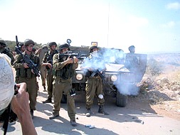
The amendments came in response to a decision taken by the Israeli High Court after a series of protests and objections on part of Palestinians affected by the Wall. The Palestinian legal measures in this case have been taken by the Jerusalem Center for Legal Aid. See Photo 3 & 4: & :


Last year's anti Wall activities in Az Zawiya village prior to the Israeli
High Court's decision- Photos courtesy of LRC).).


The previous Wall plan of October 2003, intended to expropriate larger areas of the village lands, in addition to the devastation of 400 dunums located under the route of the Wall. Although it was pushed westward towards the Armistice Line (Green Line), the Wall is expected to stretch at the length of 6 km and a maximum width of 100 meter over the lands of Az Zawiya. This will lead to the total destruction of almost 600 dunums under the path of the Wall apart from the land that will be separated behind it and whose area is estimated at hundreds of dunums. See photo 5: :
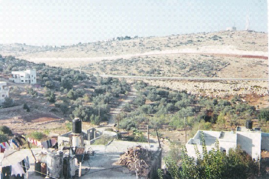

The path of the Wall can be seen close to the village homes – Photo courtesy of LRC))

  • The gradual confiscation of hundreds of dunums of land for the establishment and expansion of many Israeli settlements in Salfit governorate, including Elkana (established in 1977 and house a population of 2983 in 2004) and Sha'are Tikva (established in 1982 and houses a population of 3685 in 2004).

  • The construction of stone quarries to the west of the village expropriating more than 500 dunums of agricultural lands.

  • The erection of an army training military camp over 300 dunums of the Az Zawiya village lands.

  • 5- The continuous prevention of Palestinian farmers and land owners from tending their lands and picking olives, especially in the areas of Khallet Rumaila and Sirisiya under the pretext of their proximity to the Israeli Settlements. Such a measure, which was put in force for the fourth running year, has inflicted heavy losses on many families whose main income comes only from olives and olive oil after loosing their jobs in Israel. 


Prepared by
 The Land Research Center
LRC


Recommended For You

سلطات الاحتلال الإسرائيلي تستغل ‘المنفعة العامة’ لنهب الموارد الفلسطينية

by arij
September 30, 2025
0
سلطات الاحتلال الإسرائيلي تستغل ‘المنفعة العامة’ لنهب الموارد الفلسطينية

في الاول من شهر ايلول من العام 2025، نشرت الإدارة المدنية الإسرائيلية، الذراع الأيمن لحكومة الاحتلال الإسرائيلي أمرا عسكريا جديدا تحت عنوان " أمر ءبشأن قانون الأراضي (الاستملاك...

Read moreDetails

The Occupation Targets the Village of Raba Southeast of Jenin with Military Orders and Seizes Vast Areas of Its Lands

by arij
September 13, 2025
0
الاحتلال يستهدف بأوامر عسكرية قرية رابا جنوب شرق جنين ويصادر مساحات واسعة من أراضيها

 The Israeli occupation Army have continued their policy of plundering Palestinian lands, as their bulldozers leveled wide areas of agricultural land in the village of Raba, southeast of...

Read moreDetails

الاحتلال يستهدف بأوامر عسكرية قرية رابا جنوب شرق جنين ويصادر مساحات واسعة من أراضيها

by arij
September 13, 2025
0
الاحتلال يستهدف بأوامر عسكرية قرية رابا جنوب شرق جنين ويصادر مساحات واسعة من أراضيها

  واصلت قوات الاحتلال الإسرائيلي سياسة نهب الأراضي الفلسطينية، حيث أقدمت آلياتها على تجريف أراض زراعية واسعة في قرية رابا جنوب شرق محافظة جنين، تمهيدا لشق شارع عسكري...

Read moreDetails

Nablus Governorate’s Archaeological Sites Face Israeli Expropriation Plans

by arij
September 11, 2025
0
” المواقع الأثرية في محافظة نابلس… ساحة مفتوحة أمام مخططات المصادرة الإسرائيلية “

On 10 August, 2025, the Israeli Civil Administration (ICA), issued a booklet of military orders signed by the head of the so-called ‘Israeli Civil Administration’ in the occupied...

Read moreDetails

” المواقع الأثرية في محافظة نابلس… ساحة مفتوحة أمام مخططات المصادرة الإسرائيلية “

by arij
August 26, 2025
0
” المواقع الأثرية في محافظة نابلس… ساحة مفتوحة أمام مخططات المصادرة الإسرائيلية “

في العاشر من شهر اب من العام 2025, أصدرت الإدارة المدنية الإسرائيلية كراسة أوامر عسكرية موقعة من قبل رئيس ما يسمى "بالإدارة المدنية الإسرائيلية" في الضفة الغربية المحتلة,...

Read moreDetails
Next Post
Closing of a road and 60 commercial stores in Hebron

Closing of a road and 60 commercial stores in Hebron

LATEST NEWS

Annexation of the Jordan Valley: Implications for the Two-State Solution and Regional Stability

Annexation of the Jordan Valley: Implications for the Two-State Solution and Regional Stability

by arij
September 29, 2025
0

........................................................

Isolation of Three Villages Northwest of Jerusalem: Silent Annexation Creeps toward the Capital

عزل ثلاث قرى فلسطينية شمال غرب مدينة القدس: الضم الاسرائيلي الصامت يزحف نحو محيط العاصمة

by arij
September 24, 2025
0

........................................................

Isolation of Three Villages Northwest of Jerusalem: Silent Annexation Creeps toward the Capital

Isolation of Three Villages Northwest of Jerusalem: Silent Annexation Creeps toward the Capital

by arij
September 24, 2025
0

........................................................

سياسات التهويد في القدس: من السيطرة المكانية إلى طمس الهوية عبر التسمية

سياسات التهويد في القدس: من السيطرة المكانية إلى طمس الهوية عبر التسمية

by arij
September 23, 2025
0

........................................................

flag_yellow_lowEU-PfP-Logo

This website and its content were initiated in 1993 by the Applied Research Institute – Jerusalem (ARIJ) and the Land Research Center (LRC) with the support from the European Union up until 2023. Since then, the Applied Research Institute – Jerusalem (ARIJ) has taken over the continued development and maintenance of the website. The views expressed remain solely those of ARIJ) and do not necessarily reflect those of the European Union.

© 2025 Copyright ARIJ . All Rights reserved. .

No Result
View All Result
  • Home
  • Settlements
    • New Israeli Settlements
    • Settlement Expansion
  • Israeli Violations
    • Agriculture
    • Confiscation
    • Demolition
    • Environment
    • Eviction of Palestinians
    • Settlers Attacks
  • Bypass Roads
  • Israeli Plans
  • Segregation
    • Checkpoints
    • Closure
    • Separation Plans
  • Military Orders
  • Reports
    • Daily Report
    • Monthly Report
    • Quarterly Report

© 2025 Copyright ARIJ . All Rights reserved. .