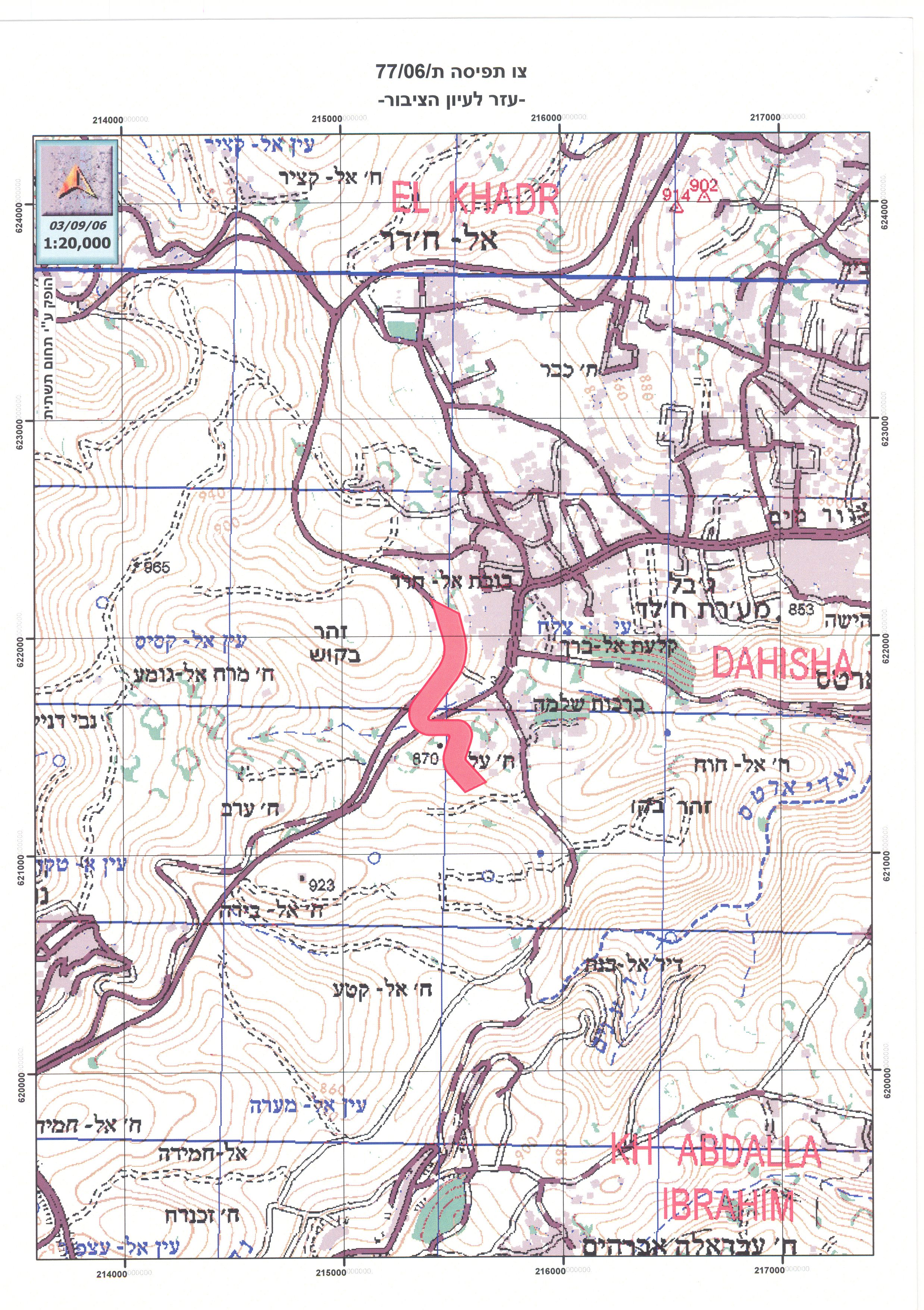
On September 4, 2006, the Israeli Forces tossed in the fields of Al Khader and Artas villages a new military order # (77/06/T) stating the confiscation of large areas of their lands to construct the Segregation Wall along the eastern extend of Bypass Road 60. According to the military order, a total of 102.2 dunums of lands from Kherbit 'Alia ('Alia Hamlet) located southwest of Artas village has been confiscated to complete the construction of the Segregation Wall in the area. The confiscated lands are located within the following Parcels:
1. Al Khader : (Parcel 2 : Thahir Bqeesh and Um Rokbah)
2. Artas: (Parcel 8 Thahir Bqeesh, Khalet Al Kurwesh and Kherbit 'Alia). See translation of military order in English.
Table 1: Translation of military order number (77/06/T)
|
Israel Defense Forces Order to Seize lands n0 77/06/T
According to my authorities as a Military Chief Commander in the Region of Judea and Samaria, and as I believe that it is imperative for military reasons due to the special security situation in the region, I order the following:
1- In This Order:
The 'Map' – signed in scale 1: 10000 and attached to the order is an essential part of this order.
The 'Lands' – An area of land which is 102 dunums and 200 meters marked in red in the map and is located in lands of:
AL Khader : (parcel 2: Thahir Bqeesh and Um Rokbah ) Artas : (parcel 8 : Thahir Bqeesh , Khalet Al Kurweesh and Kherbit Alia )
2- I announce by that the above mentioned lands are seized for imperative military purposes, to construct the wall in Kherbit 'Alia area on lands of Al Khader and Artas villages.
3- The IDF seize the lands and an absolute control of the land is given to the Military Chief Commander of the Central Region through the Ministry of Defense Chief Officer in the Civil Administration Office.
4- Copies of this military order and the attached map are handed out to Land owners or to the District Co-ordination Office in Bethlehem.
5A- This military order is to be notified to Land Owners or those who act on behalf of them by posting it at the District Coordination Office in Bethlehem and dispersing it on the lands by any possible mean.
5B- Copies of the military order and the attached map are available for interested parties at the following places:
5C- Copy of the military order and the attached map is set at Bethlehem District Coordination Office Board for 10 days from the issuance date of the military order, as mentioned in Part (5A).
6- Land owners or those who act on behalf of ownership have the right to object the military order in 7 days from the date of the field visit as mentioned in Part (5A) above through the District Coordination Office in Bethlehem or at the Office of the juridical advisor in the region.
7- Land Owners have the right to go to the District Coordination Office in Bethlehem to get usage expenses and compensation.
8- This order is valid from the date it was signed and until 31/12/2007.
9- This order is called: 'Order to seize lands n0 77/06/T (Judea & Samaria) 5765-2005.
Ya'er Naveh
|
See Copy of Military Order
Status of the Military order number (77/06/T) :
On April 30, 2006, the Israeli ministry of defense published on its website an updated plan of the Segregation Wall, showing changes at some sections of the Segregation Wall route. The changes were mostly noted in Salfit, Jerusalem and Bethlehem areas.
As to the subject of the military order at hand (77/06/T), it constituted an adjustment to the April 30, 2006 Segregation plan update; as plan was to have the Segregation Wall run along bypass road 60 (starting west of Al Khader Village) till west of Artas where it direct towards the southeast to reach west of Khalayel Al Louz, it then heads southwest towards Wadi Al Nis and encompasses all of Efrat settlement.
The new military order shows a crescent-like shift of the Wall’s route along bypass road 60, as it reaches south of Al Khader and northwest of Efrat settlement. The shift is inclined east of the bypass road as it moves the Segregation Wall closer to the Palestinian built-up area and some of the Palestinian houses will be literally few meters away from the Wall route; more than that, the new shift will steal of more of whatever lands left for Palestinian villages’ have for future development.
Isolating the western rural area of Bethlehem
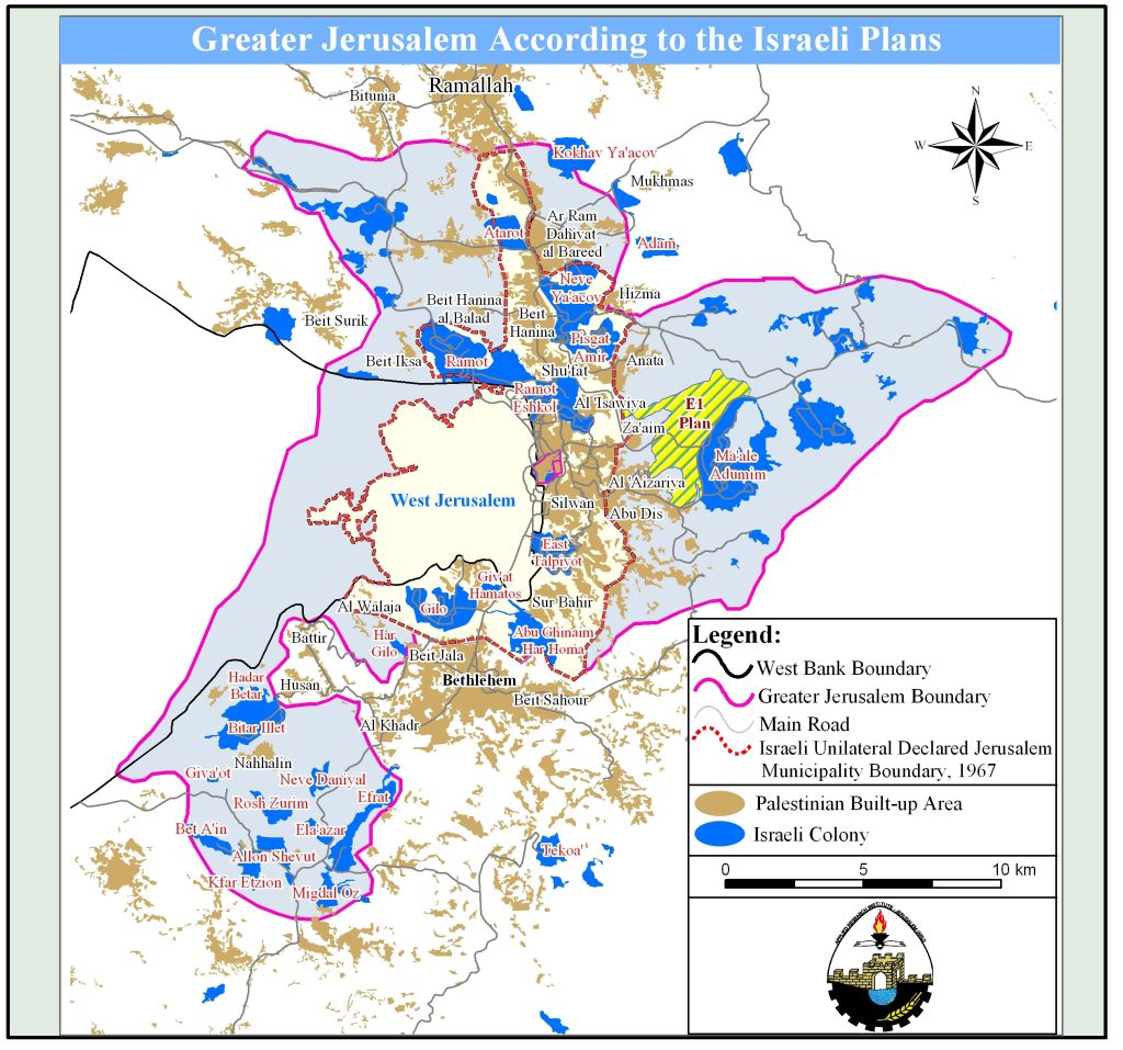
Once the Segregation Wall west of Bethlehem is completed, the entire western rural area will be isolated from the governorate’ s center of life, as residents (exceed 20,000 Palestinian) of several Palestinian communities trapped in the western rural area will be trapped within what the Israelis call, the “Gush Etzion” settlements bloc, which according to Israeli plans is a part of the 'Greater Jerusalem' Israeli plan which will include 3 settlement blocs (Ma'ale Adumim, Giva'at Ze'ev and Gush Etzion) to Jerusalem and subsequently to Israel. Click here for previously written case studies (1 2 3). See Map of Greater Jerusalem
The Segregation Wall in Bethlehem Governorate will stretch a length of 52.2 kilometers across Bethlehem’s lands and will isolate in the process some 73 km² (73000 dunums) of land, 12% of the Governorate’s area (608 km²).
Series of Israeli military orders issued for Wall Constructions In Al Kader and Artas villages:
During the last couple of years, the Israeli Army issued several military orders to facilitate the construction of the Segregation Wall in Al Khader and Artas villages. Table 1 below shows the list of military orders along with the lands stated for confiscation
Table 1: Issued Military Orders in Al Khader & Artas villages
|
Military order |
Date of Issue |
Total confiscated Area ( donoms) |
purpose |
Community |
|
|
93/01 |
13/01/2005 |
7.5 |
wall |
Al Khader |
|
|
135/05/T |
19/07/2005 |
307.5 |
wall |
Al Khader |
|
|
201/05/T |
02/11/2005 |
94.3 |
Wall |
Al Khader &Beit fajar |
|
|
21/99/T |
08/08/2004 |
4.7 |
Wall |
Al Khader |
|
|
24/06/T |
19/02/2006 |
170 |
Wall & Road construction |
Al Khader & Beit Jala |
|
|
69/06/T |
25/06/T |
102 |
Wall & Terminal |
Al Kader, Beit Jala & Beit Ummar |
|
|
137/05/T |
07/07/2005 |
162 |
Wall |
Artas |
|
Source: ARIJ 2006 Military Orders Database
Conclusion:
The construction of the Segregation Wall is a flagrant violation of International law rules and conventions and the United Nation resolutions which do not sanction the annexation of land by force and calls for the protection of rights of people under occupation as stated by Geneva Conventions, article 47: 'Protected persons who are in occupied territory shall not be deprived, in any case or in any manner whatsoever, of the benefits of the present Convention by any change introduced, as the result of the occupation of a territory, into the institutions or government of the said territory, nor by any agreement concluded between the authorities of the occupied territories and the Occupying Power, nor by any annexation by the latter of the whole or part of the occupied territory'.
Article 46 of the Hague Convention (Laws and Customs of War on Land (Hague II); July 29, 1899).Prohibits the confiscation of private property in occupied territory. Therefore, the confiscation of land by the Israeli government for construction of the Segregation Wall is a blatant violation to International laws and Conventions.
:::::::::::____
[1] 'Alia Hamlet (Kherbit 'Alia) contains remains of a Roman town, mosaic floor, water channels, in addition to rock-carved tombs. See Map of military order
Prepared by
The Applied Research Institute – Jerusalem
ARIJ


