• About The Project
  • Palestine in Century
  • Selected Maps
  • Glossary
  • About ARIJ
  • About LRC
  • By Year
    • Case Studies By Year
    • Daily Report By Year
Tuesday, May 26, 2026
POICA
No Result
View All Result
  • Home
  • Settlements
    • New Israeli Settlements
    • Settlement Expansion
  • Israeli Violations
    • Agriculture
    • Confiscation
    • Demolition
    • Environment
    • Eviction of Palestinians
    • Settlers Attacks
  • Bypass Roads
  • Israeli Plans
  • Segregation
    • Checkpoints
    • Closure
    • Separation Plans
  • Military Orders
  • Reports
    • Daily Report
    • Monthly Report
    • Quarterly Report
  • Home
  • Settlements
    • New Israeli Settlements
    • Settlement Expansion
  • Israeli Violations
    • Agriculture
    • Confiscation
    • Demolition
    • Environment
    • Eviction of Palestinians
    • Settlers Attacks
  • Bypass Roads
  • Israeli Plans
  • Segregation
    • Checkpoints
    • Closure
    • Separation Plans
  • Military Orders
  • Reports
    • Daily Report
    • Monthly Report
    • Quarterly Report
No Result
View All Result
POICA
No Result
View All Result

Halt–construction warnings against a number of Palestinian houses and stores in Haris Village

November 26, 2007
in Military Orders
Halt–construction warnings against a number of Palestinian houses and stores in Haris Village

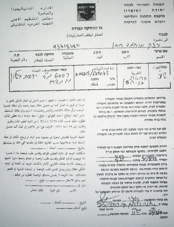
On October 27th, 2007, the Israeli occupation authorities sent halt-construction warnings to the owners of four houses and two stores in the village of Haris, Salfit governorate, under the pretexts of un-licensing and for being close to bypass road number 505 connecting between Ariel colony and 1949 Armistice Line (Green Line). The following table provides data about the threatened premises:


No.

Owner's name

Owner's age

Information about the threatened premises

1

Abdullah Mohammed Daood

49

Commercial store

2

Hasan Khalid Shaja'ieh

23

Commercial store

3

Mustafa Hussein Taysir

68

A two storey completed house

4

Hussein Hamid Daood

46

A one storey completed house

5

Abdullah Musa Abu Baker

66

A two storey uncompleted house

6

Adnan Fawzi Abu Baker

35

A two storey uncompleted house


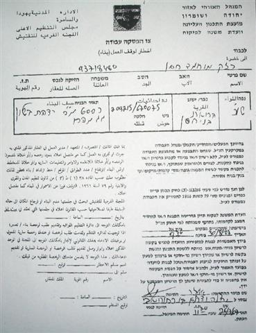
(Photo 1: a copy of one of the halt-construction warnings)


Legal action

The owners of the threatened structures, in cooperation with the village local council, presented an objection to the Israeli planning committee at Beit Eil 'civil administration' near Ramallah against the warnings. Also, they are planning to send another objection to the Israeli supreme court.
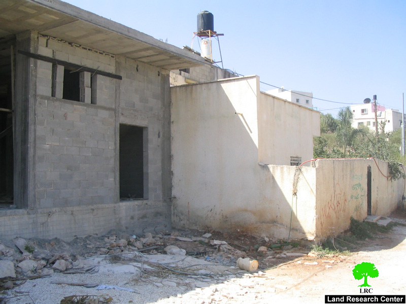
 

(Photo 2: one of the under construction threatened houses in Haris village)


Apart from the latest warnings  8 others have been issued since the year 2000 under the pretext of building in zone C of Oslo agreement's classifications under total Israeli civic and military supervision .
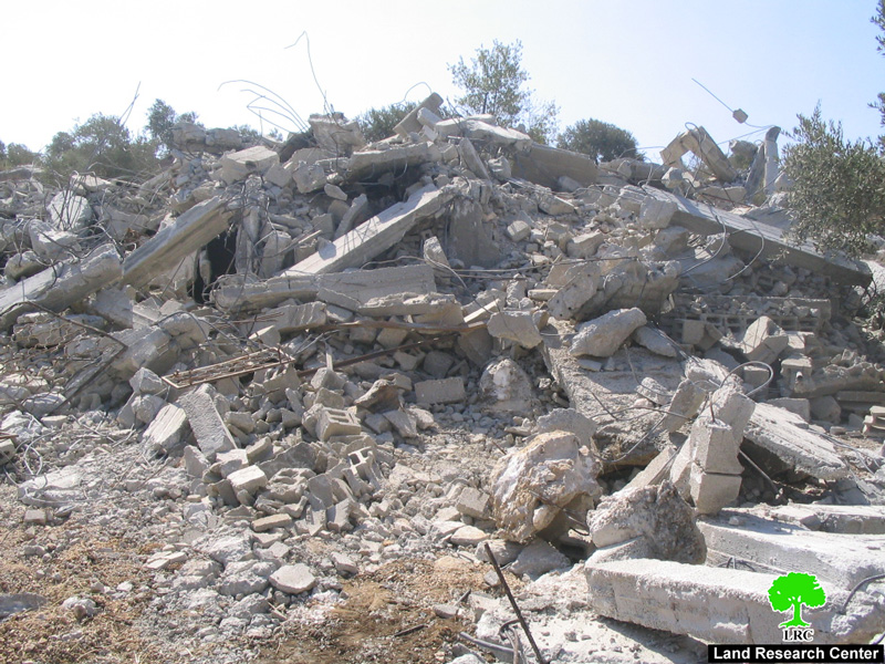
 

(Photo 3:  a previously demolished house in Haris village)


Introduction to Haris village

Located 7 km to the west of Salfit city. It has a total surface land area of 8450 dunums (one dunum equals 1000 m2) of which only 319 dunums designed by the Israeli occupation authorities as built up area. The Palestinian Central Bureau of Statistics' population projection shows that the village of Haris will have a total of 3458 people by the end of this year. See Map 1
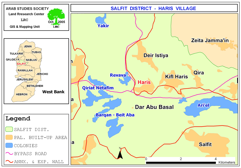


The village has lost almost half of its land – 4000 dunums – for the establishment of the bypass road number 505, Segregation Wall and the following four colonies:


Colony name

Date of establishment

Municipal area

Built up area

Population

2005

Barkan

1981

2720

349

1231

Kiryat Netafim

1982

1540

162

438

Revava

1991

1540

160

827

Ariel

1978

13775

2479

16520

Total

19575

3150

19016


Source: – GIS unit at LRC.

            – Foundation for Middle East Peace- Washington.


Zone C: deducted at the expense of Palestinian planning schemes

The Israeli occupation authorities preceded the Olso agreement in 1993 with the announcement of planning schemes for all the Palestinian cities, towns and villages in the West Bank in which it unilaterally drew up the borders of the built up areas for each Palestinian residential area based upon Israeli needs and greed. That is, all the Israeli – announced Palestinian built up schemes were limited to certain areas under the names of zone A and B and the remaining lands were announced C which remained under total Israeli civic and security affairs. The reason behind this policy was to name as much land as possible under zone C before going into talks with the Palestinian side.


As a direct effect of this policy many villages and towns has lost most of their land to zone C where Palestinians are not allowed to get any construction permissions on this land. The village of Haris is a typical example. All of the threatened structures are located in zone C outside the borders of the Israeli imposed built up area whose total area is 319 dunums. This situation has put the owners and inhabitants of these houses in constant fear as Mr. Mustafa Hussein Taysir, one of the owners, had said to LRC field worker: 'Me and my family have been living in a continuous nightmare since we received the notification form last month. This feeling of insecurity is very bad for all of us. I was forced to build here because I have no other land to build  on'. 


Settler's violence

In related development,  Israeli settlers from Qiriyat Netafim colony prevented Palestinian farmers from Haris and other neighboring villages from picking olives during the latest harvesting season in the month of October under the pretext that the land is located in the security belt of the colony. The settlers used their machine guns to open fire in the air to dismiss olive pickers out of their fields.   This act of terrorism on the part of settlers had deprived about 60 families from their only source of living, thus, increasing the level of unemployment and poverty in the Palestinian villages in that particular area.


Prepared by
The Land Research Center – Jerusalem
LRC

Recommended For You

سلطات الاحتلال الإسرائيلي بصدد الاستيلاء على موقع قبر النبي صموئيل شمال غرب مدينة القدس

by arij
May 23, 2026
0
سلطات الاحتلال الإسرائيلي بصدد الاستيلاء على موقع قبر النبي صموئيل شمال غرب مدينة القدس

 نشرت سلطات الاحتلال الإسرائيلي في الثامن عشر من شهر أيار من العام 2026 اعلانا مفاده الاستيلاء على الأراضي الفلسطينية في قرية النبي صموئيل شمال غرب القدس المحتلة. وجاء...

Read moreDetails

إقامة منطقة عسكرية عسكرية داخل أراضي (أ) في جنين

by arij
May 19, 2026
0
إقامة منطقة عسكرية عسكرية داخل أراضي (أ) في جنين

   في السابع من شهر أيار من العام 2026، وزعت سلطات الاحتلال الإسرائيلي أمرا عسكريا جديدة على أهالي مدينة جنين يقضي بمصادرة 7.2 دونما من الأراضي الفلسطينية في...

Read moreDetails

“بمساحة اجمالية 177 دونما من أرضي البيرة وبيتين”, طريق استيطاني لخدمة البؤر الاستيطانية في محافظة رام الله

by arij
May 18, 2026
0
“بمساحة اجمالية 177 دونما من أرضي البيرة وبيتين”, طريق استيطاني لخدمة البؤر الاستيطانية في محافظة رام الله

في الحادي عشر من شهر أيار من العام 2026, نشرت دائرة أراضي إسرائيل اعلانا جديدا يقضي بمصادرة المزيد من الأراضي الفلسطينية في محافظة رام الله لأغراض استيطانية في...

Read moreDetails

“في خدمة مستوطنة ناحال حيلتس”, طريق استيطاني إسرائيلي جديد على أراضي بتير وبيت جالا في محافظة بيت لحم

by arij
May 18, 2026
0
“في خدمة مستوطنة ناحال حيلتس”, طريق استيطاني إسرائيلي جديد على أراضي بتير وبيت جالا في محافظة بيت لحم

تواصل سلطات الاحتلال الإسرائيلي إحكام سيطرتها على المزيد من الأراضي الفلسطينية في الضفة الغربية المحتلة، وهذه المرة من خلال استهداف أراضي محافظة بيت لحم. ففي السادس والعشرين من...

Read moreDetails

مناطق نفوذ المستوطنات ودورها في إعادة تشكيل الجغرافيا الفلسطينية

by arij
April 23, 2026
0
مناطق نفوذ المستوطنات ودورها في إعادة تشكيل الجغرافيا الفلسطينية

أصدرت سلطات الاحتلال الإسرائيلي في العاشر من شهر نيسان 2026 الكراسة رقم (273)، وهي وثيقة تضم مجموعة من المناشير والأوامر والتعيينات الإسرائيلية المتعلقة بالجوانب الأمنية والعسكرية والإدارية، إضافة...

Read moreDetails
Next Post

مبادرات اسرائيلية جديدة لدعم الاستيطان في الاراضي الفلسطينية المحتلة

LATEST NEWS

سلطات الاحتلال الإسرائيلي بصدد الاستيلاء على موقع قبر النبي صموئيل شمال غرب مدينة القدس

سلطات الاحتلال الإسرائيلي بصدد الاستيلاء على موقع قبر النبي صموئيل شمال غرب مدينة القدس

by arij
May 23, 2026
0

........................................................

إقامة منطقة عسكرية عسكرية داخل أراضي (أ) في جنين

إقامة منطقة عسكرية عسكرية داخل أراضي (أ) في جنين

by arij
May 19, 2026
0

........................................................

الآثار كأداة للضم الزاحف: مشروع القانون الإسرائيلي لإعادة هندسة الجغرافيا والهوية في الضفة الغربية

الآثار كأداة للضم الزاحف: مشروع القانون الإسرائيلي لإعادة هندسة الجغرافيا والهوية في الضفة الغربية

by arij
May 23, 2026
0

........................................................

النكبة الفلسطينية في ذكراها الثامنة والسبعين: من التطهير العرقي إلى الإبادة وإعادة هندسة الجغرافيا الفلسطينية 

النكبة الفلسطينية في ذكراها الثامنة والسبعين: من التطهير العرقي إلى الإبادة وإعادة هندسة الجغرافيا الفلسطينية 

by arij
May 18, 2026
0

........................................................

flag_yellow_lowEU-PfP-Logo

This website and its content were initiated in 1993 by the Applied Research Institute – Jerusalem (ARIJ) and the Land Research Center (LRC) with the support from the European Union up until 2023. Since then, the Applied Research Institute – Jerusalem (ARIJ) has taken over the continued development and maintenance of the website. The views expressed remain solely those of ARIJ) and do not necessarily reflect those of the European Union.

© 2026 Copyright | ARIJ | All Rights reserved.

No Result
View All Result
  • Home
  • Settlements
    • New Israeli Settlements
    • Settlement Expansion
  • Israeli Violations
    • Agriculture
    • Confiscation
    • Demolition
    • Environment
    • Eviction of Palestinians
    • Settlers Attacks
  • Bypass Roads
  • Israeli Plans
  • Segregation
    • Checkpoints
    • Closure
    • Separation Plans
  • Military Orders
  • Reports
    • Daily Report
    • Monthly Report
    • Quarterly Report

© 2026 Copyright | ARIJ | All Rights reserved.