• About The Project
  • Palestine in Century
  • Selected Maps
  • Glossary
  • About ARIJ
  • About LRC
  • By Year
    • Case Studies By Year
    • Daily Report By Year
Saturday, June 20, 2026
POICA
No Result
View All Result
  • Home
  • Settlements
    • New Israeli Settlements
    • Settlement Expansion
  • Israeli Violations
    • Agriculture
    • Confiscation
    • Demolition
    • Environment
    • Eviction of Palestinians
    • Settlers Attacks
  • Bypass Roads
  • Israeli Plans
  • Segregation
    • Checkpoints
    • Closure
    • Separation Plans
  • Military Orders
  • Reports
    • Daily Report
    • Monthly Report
    • Quarterly Report
No Result
View All Result
POICA
No Result
View All Result

Israeli Occupation Issues 10 Stop Work Orders

March 11, 2011
in Military Orders
Israeli Occupation Issues 10 Stop Work Orders
Violation: The issuing of 10 Stop Work Orders against Palestinian structures including 4 houses.
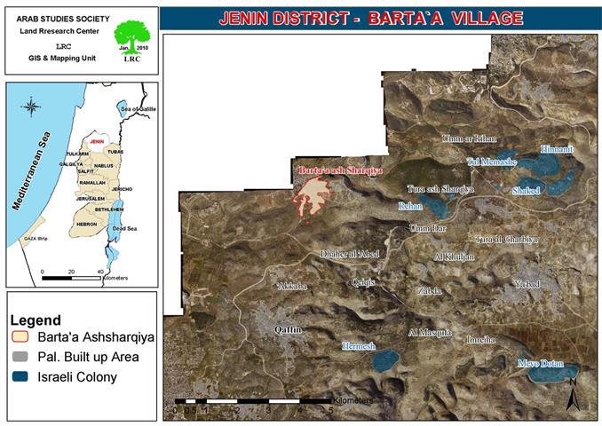
Location: The village of Barta’a Al Sharqiyya west of Jenin Governorate.
Date: March 7th, 2011


Preface:
The village of Barta’a Al Sharqiyya fell victim twice for the Israeli occupation policies; in 1948 it lost a large portion of its lands as the Green Line approved by the United Nations has separated between members of the same family as ones stayed on the “Israeli” side while being supported only by a small valley from their relatives. The fallout of the village continued in the aftermath of the occupation of 1967 as the houses, trees and properties were targeted by the occupation forces throughout the duration of the occupation especially that most of the lands of the village were classified as Area C in accordance with the Oslo Accords.
 
Details:
On March 7th, 2011, the Israeli so-called “Civil Administration” raided the village and distributed 10 Stop Work Orders against Palestinian houses and agricultural structures under the pretext of being built in Area C “without a permit.” Occupation forces provided the owners of the structures only until Match 31st to file an appeal against the Orders and to try and get the needed permits. 
 
The issued orders come in line with the practiced policies implemented by the Israeli occupation forces to vacate the land from its original inhabitants as a prelude for confiscating it. As of today, more than 190 Stop work Orders have been issued against houses and other structures in the village. That is in addition to the actual demolition of 19 structures in the village under the same pretext.
The following table lists the issued Orders and its relevant information:
 
 
Name
No. of Structures
No. of Family Members
Type of Structure
Area in m2
Construction Material
Farouk Mohammad Kabha
1
7
Sheep brux
250
Zinco
Farouk Mohammad Kabha
1
0
Room
50
Zinco
Farouk Mohammad Kabha
1
0
Brux under construction
300
Zinco
Mohammad Ibraheem Kabha
1
6
Container
50
 
Kamal Abdel Qader Kabha
1
8
Container
50
 
Mohammad tawfeeq Kabha
1
5
Sheep brux
100
Zinco
Manal Ahmad Kabha
1
8
Under construction house
150
Cement
Mohammad Tala’at Kabha
1
2
Under construction house
150
Cement
Shadi Mustafa Qundus
1
4
Under construction house
150
Cement
Mohammad Mustafa Qundus
1
3
Under construction house
150
Cement
TOTAL
10
43


Source: Land Research Center – Israeli Violation Monitoring Unit
 
The Village of Barta’a:
The village of Barta’a Al Sharqiyya is located 30 kilometers west of the city of Jenin. The closest town to it is Ya’abad located 1 kilometers east of it. Three small khirbets surround the village including Khirbet Barta’a, Khirbet Abduallah Younis and Khirbet Al Mintar. The Israeli Racist Isolation Wall surrounds the villages from its eastern and southern directions leading to its separation from the West Bank. The area of its Master Plan is around 3,500 dunums while the total area of the village is 21,000 dunums. Its population (according to the village council) is 3900 most of them are from the Kabhha clan.
 
Israeli occupation forces started to establish the Racist Wall around the village in 2002, thus turning the lives of Palestinians into an unbearable hell with only one gate that came to be known as Al Reehan Checkpoint. The checkpoint is the only entry point into and out of the village. To make things worse, since May 16th, 2007, the administration of the checkpoint was handed over to a private security company and the checkpoint became as a “port” that required extensive search of each person entering or existing the village
 
 
Picture 1-2:
 
 
Prepared by
The Land Research Center
LRC


Recommended For You

الاحتلال الاسرائيلي يوسع سيطرته على أراضي جبل الفرديس بمصادرة 317 دونم اخرى

by arij
June 15, 2026
0
الاحتلال الاسرائيلي يوسع سيطرته على أراضي جبل الفرديس بمصادرة 317 دونم اخرى

  في الخامس والعشرين من شهر ايار من العام 2026 نشرط سلطات الاحتلال الاسرائيلي امرا عسكريا جديدا يحمل اسم "أمر بشأن قانون الأراضي استملاك للمصلحة العامة) (يهودا والسامرة)...

Read moreDetails

بواقع 19 دونما – سلسلة من الأوامر العسكري الإسرائيلي تستهدف أراضي محافظة بيت لحم بذريعة الأغراض العسكرية

by arij
June 13, 2026
0
بواقع 19 دونما – سلسلة من الأوامر العسكري الإسرائيلي تستهدف أراضي محافظة بيت لحم بذريعة الأغراض العسكرية

سلمت سلطات الاحتلال الإسرائيلي أهالي محافظة بيت لحم سلسلة من الأوامر العسكرية لمصادرة مساحات شاسعة من الأراضي الفلسطينية في المحافظة بذريعة أغراض عسكرية. واستهدفت الأوامر العسكرية الجديدة عددا...

Read moreDetails

بمساحة اجمالية بلغت 208 دونما – سلطات الاحتلال الإسرائيلي تصادر الاراضي في محافظة طوباس لصالح معسكر اسرائيلي

by arij
June 13, 2026
0
بمساحة اجمالية بلغت 208 دونما – سلطات الاحتلال الإسرائيلي تصادر الاراضي في محافظة طوباس لصالح معسكر اسرائيلي

سلّمت سلطات الاحتلال الإسرائيلي، في السابع من حزيران 2026، أهالي مدينة طوباس شمال الضفة الغربية المحتلة أمراً عسكرياً جديداً بعنوان: "أمر بشأن وضع اليد على أراضٍ رقم 79/26/ت...

Read moreDetails

الاحتلال يرسّخ بؤرة “يتسيف” الاستيطانية عبر تخصيص 92 دونماً من أراضي بيت ساحور

by arij
June 9, 2026
0
الاحتلال يرسّخ بؤرة “يتسيف” الاستيطانية عبر تخصيص 92 دونماً من أراضي بيت ساحور

أصدر جيش الاحتلال الإسرائيلي في الخامس من شهر اذار من العام 2026 إعلاناً عسكرياً جديداً موقع من قبل ما يُسمّى بـ “قائد قوات جيش الدفاع الإسرائيلي في منطقة...

Read moreDetails

كراسة أوامر إسرائيلية جديدة تمهد لمصادرة أكثر من 20 ألف دونم في الضفة الغربية المحتلة

by arij
June 9, 2026
0
كراسة أوامر إسرائيلية جديدة تمهد لمصادرة أكثر من 20 ألف دونم في الضفة الغربية المحتلة

في الخامس من شهر اذار من العام 2026، أصدرت سلطات الاحتلال الإسرائيلي كراسة جديدة من الأوامر العسكرية التي تهدف إلى توسيع نطاق النشاطات الاستيطانية على الأراضي الفلسطينية، وذلك...

Read moreDetails
Next Post
Stop Work Orders in Khirbet Umm Zaytouna in Yatta Town

Stop Work Orders in Khirbet Umm Zaytouna in Yatta Town

LATEST NEWS

الاحتلال الاسرائيلي يوسع سيطرته على أراضي جبل الفرديس بمصادرة 317 دونم اخرى

الاحتلال الاسرائيلي يوسع سيطرته على أراضي جبل الفرديس بمصادرة 317 دونم اخرى

by arij
June 15, 2026
0

........................................................

بواقع 19 دونما – سلسلة من الأوامر العسكري الإسرائيلي تستهدف أراضي محافظة بيت لحم بذريعة الأغراض العسكرية

بواقع 19 دونما – سلسلة من الأوامر العسكري الإسرائيلي تستهدف أراضي محافظة بيت لحم بذريعة الأغراض العسكرية

by arij
June 13, 2026
0

........................................................

بمساحة اجمالية بلغت 208 دونما – سلطات الاحتلال الإسرائيلي تصادر الاراضي في محافظة طوباس لصالح معسكر اسرائيلي

بمساحة اجمالية بلغت 208 دونما – سلطات الاحتلال الإسرائيلي تصادر الاراضي في محافظة طوباس لصالح معسكر اسرائيلي

by arij
June 13, 2026
0

........................................................

الاحتلال يرسّخ بؤرة “يتسيف” الاستيطانية عبر تخصيص 92 دونماً من أراضي بيت ساحور

الاحتلال يرسّخ بؤرة “يتسيف” الاستيطانية عبر تخصيص 92 دونماً من أراضي بيت ساحور

by arij
June 9, 2026
0

........................................................

flag_yellow_lowEU-PfP-Logo

This website and its content were initiated in 1993 by the Applied Research Institute – Jerusalem (ARIJ) and the Land Research Center (LRC) with the support from the European Union up until 2023. Since then, the Applied Research Institute – Jerusalem (ARIJ) has taken over the continued development and maintenance of the website. The views expressed remain solely those of ARIJ) and do not necessarily reflect those of the European Union.

© 2026 Copyright | ARIJ | All Rights reserved.

No Result
View All Result
  • Home
  • Settlements
    • New Israeli Settlements
    • Settlement Expansion
  • Israeli Violations
    • Agriculture
    • Confiscation
    • Demolition
    • Environment
    • Eviction of Palestinians
    • Settlers Attacks
  • Bypass Roads
  • Israeli Plans
  • Segregation
    • Checkpoints
    • Closure
    • Separation Plans
  • Military Orders
  • Reports
    • Daily Report
    • Monthly Report
    • Quarterly Report

© 2026 Copyright | ARIJ | All Rights reserved.