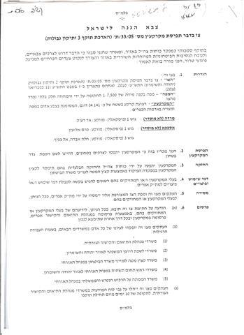
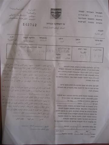
On the 3rd of January 2012, the Israeli Civil Administration extended the validity of three military orders that were issued previously (in 2004) for the confiscation of vast areas of Palestinian lands in Iskaka village east of Salfit city for the construction of the Israeli Segregation Wall. The military orders hold numbers 138/05/T, 33/05/T and 45/04/t and state to extend the validity of work as to complete the construction of sections of the wall that haven’t been completed yet in the area.
It is worth mentioning that the issued orders come to corroborate the map revealed by the Israeli Army on April 30, 2007, illustrating the route of Segregation Wall in Iskaka village and to correlate previous military orders issued in that area, Table 1 gives details of the military orders issued in Iskaka village
|
Table 1: Details of the Israeli military Orders
|
|
No.
|
Israeli Military Order Number
|
Area of targeted lands
|
|
1
|
138/05/T
|
48.7
|
|
2
|
33/05/t
|
34.8
|
|
3
|
45/04/t
|
82.2
|
|
Total
|
|
165.7
|
|
Source: Iskaka village Council 2012
|
According to head of Iskaka Village Council, the orders are going to be applied on 166 dunums of lands, on the western and southwestern edges of the village, to complete the construction of the Israeli Segregation Wall to the east of Ariel settlement.
Furthermore, it is worth mentioning that residents of Iskaka village received the military orders on the 3rd of January 2012, almost one month after they were issued on the 8th of December 2011, which prevents them from filing objections against the issued military orders at the Israeli Civil Administration office in Ma’ael Efrayem since the period set for objection is ten days from issuance date of the order and thus residents of Iskaka lost their right to object the orders as the period set for objection ended.
Map 01
GIS Unit / ARIJ 2012
Moreover, the original military orders were issued for the first time in the year 2004 and came into force since the date they were signed till the 31 of January 2007, a time that was scheduled for the wall to be built and completed in the area; However, the wall wasn’t totally built due to the appeals and objections filed by Palestinians to the Israeli Supreme Court against the construction of the wall in the area and its effect on the ground.
This in turn prompted the Israeli government to issue an extension of validity to the Israeli military orders until the 31st of December 2011 so that Israel could complete the construction of the wall in the area. And since the Israeli ministry of Defense didn’t again complete the construction of the wall during the period designated in the first extension order, a second extension of validity was issued, until the 31st of December 2014, to enable the Ministry of Defense build the wall sections that haven’t been completed in the area, most specifically around Ariel settlement, which is located within the Ariel finger, part of the Ariel settlement bloc that is planned to be annexed and kept under Israeli’s sovereignty upon wall completion.
Some Previous Israeli attacks against the lands of Iskaka village � Salfit Governorate
On the 12
th of October 2011, the Israeli settlers of Kfar Taphuh settlement razed lands between Iskaka and Yasuf Villages east of Salfit city, and installed 4 new mobile homes in the area and surrounded them with barbed wires. The razed lands are located between the settlements of Kfar Taphuh and Shevut Rachel (Rechalim) and are owned by Hamdallah Yousef Abu-Hakmeh, Daoud Abdl-Qadir Abu-Thahir, Abdl-Qadir Ahmad Abu-Hakmeh, Ahmad Hries Lami and Ahmad Awad Harb. For more details follow the following link: check the following case study:
Israeli Settlers Rage jammed on the villages of Iskaka and Yasouf ‘Razing Palestinian lands for expanding Nofei Nehemia outpost’
Furthermore, on the 13
th of October 2011, the Israeli settlers of Rechalim settlement hindered Palestinian land owners from entering their 22 dunums of lands that were confiscated in 2009. The confiscated lands are occupied by more than 16 settlers’ mobile homes which were established with the facilitation of the Israeli Occupation Army. For more details, check the following link:
‘A New Colonial Outpost in Iskaka and Yasouf â�� Salfit’
Moreover, on the 3
rd of August 2010, the Israeli occupation army hindered Palestinian land owners from continuing the work on rehabilitating 25 dunums of lands in Al Qannina area southeast of Iskaka village under the pretext of lacking valid building permits to rehabilitate the lands, as they are located in area c which falls under the complete control of Israel according to OSLO II Interim agreement of 1995. The soldiers went on to threaten land owners to confiscate their equipments and bulldozers if they don’t leave the land immediately. In addition to that, Israeli occupation army delivered an order to vacate the lands targeted for rehabilitation and ordered the returning of lands to their previous status within 45 days as the targeted lands are classified as â��State Landâ�� According to the order. For more details follow the following link:
The Prevention of 15 Palestinian Farmers from Rehabilitating their Land in Iskaka villageIskaka Village
Iskaka village is located 4 km east of Salfit City, in the northern part of the West Bank and has a total population of 1400 residents. It is bordered by the settlement of Ariel from the east, Rechalim Israeli settlement and Yasuf village from the west, Kfar Taphuh settlement from the north and the village of Al Lubban Ash Sharqiya from the south. The village has a total land area of 5357 dunums, including 131 dunums that were confiscated for the establishment of the settlement of Ariel, and 150 dunums that were isolated from the village’s lands for the construction of the Israeli Segregation wall which extends about 1.7 km on lands of the village. Furthermore, the Israeli By-pass Road # 4775 penetrates deep inside the village lands and geographically dissects it into two noncontiguous parts, northern and southern.
Conclusion
Through the construction of the Segregation Wall, the Israeli Government seeks to confiscate as much lands as possible and annex the largest number of Israeli settlements where the majority of Israeli settlers’ population lives. The latest version of the Israeli Segregation Wall map indicates that upon the completion of the Wall, a total of 107 Israeli settlements with more than 85% of the total Israeli settlers population will be annexed to Israel’s proper.
This clearly contradicts Israel’s claim that the construction of the wall comes for security considerations. This in turn Constitutes a flagrant violation of many human rights under International Law, The Hague Regulations of 1907 and the Fourth Geneva Convention of 1949, some of which are listed here: (1) Article 49 of the 4th Geneva Convention, Para. 1 states that ‘Individual or mass forcible transfers, as well as deportations of protected persons from occupied territory to the territory of the Occupying Power or to that of any other country, occupied or not, are prohibited, regardless of their motive’. (2) Additionally, Article 49 â�� Para. 6 states: ‘The Occupying Power shall not deport or transfer parts of its own civilian population into the territory it occupies’. (3) Furthermore, article 53 of the Fourth Geneva Convention also affirms that ‘any destruction by the Occupying Power of real or personal property belonging individually or collectively to private persons, or to the State, or to other public authorities, or to social or cooperative organizations, is prohibited, except where such destruction is rendered absolutely necessary by military operations;’ (5) and article 147 of the Fourth Geneva Convention clearly prohibits, ”extensive destruction and appropriation of property, not justified by military necessity and carried out unlawfully and wantonly.” Moreover, article 23 of The Hague Regulations of 1907 expressly forbids an occupying power ‘to destroy or seize the enemy’s property, unless such destruction or seizure be imperatively demanded by the necessities of war’.
Prepared by:


