• About The Project
  • Palestine in Century
  • Selected Maps
  • Glossary
  • About ARIJ
  • About LRC
  • By Year
    • Case Studies By Year
    • Daily Report By Year
Sunday, October 19, 2025
POICA
No Result
View All Result
  • Home
  • Settlements
    • New Israeli Settlements
    • Settlement Expansion
  • Israeli Violations
    • Agriculture
    • Confiscation
    • Demolition
    • Environment
    • Eviction of Palestinians
    • Settlers Attacks
  • Bypass Roads
  • Israeli Plans
  • Segregation
    • Checkpoints
    • Closure
    • Separation Plans
  • Military Orders
  • Reports
    • Daily Report
    • Monthly Report
    • Quarterly Report
No Result
View All Result
POICA
No Result
View All Result

Maale Shomron puts hand on a piece of land in Qalqiliya

August 5, 2014
in Military Orders
Maale Shomron puts hand on a piece of land in Qalqiliya


Violation: a confiscation order served on a land

Date: 05/08/2014

Location: Azzun and Kfar Thulth town/ Qalqiliya

Perpetrators : the army of the Israeli occupation

Victims: a number of famers from the two towns

Details:

The army commander of the Israeli occupation in the West Bank issued an order to put hand on 11.769 dunum from the lands of Azzun al-Shamalyeih and Kfar Thulth, east of Qalqiliya governorate.

According to the military order no. (T/20/12) issued on 05/08/2014 with the map attached to it, the  purpose behind this order is to set up a segregating fence around   the periphery of Maale Shomron colony  for the sake of reinforcing its security level. This fence is the second of a type after the one set up in 2000.


Photo of the military order attached with maps

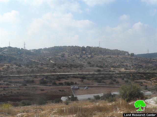
Photo3: Maale Shomron colony with the surrounding fence


The targeted lands are located on parts of Azzun lands within the natural blocks no.(10,12,13) ; in the locations of al-Kafan, Harikt al-Kafan, and Harikat Farha. In addition to that, the natural block no.6 from the lands of Kfar Thulth; locations of al-Kafan , al-Hrybeih , and Khirbet el-Jam'in was also targeted, taking into consideration that the major part of the targeted lands are private properties while the other part is considered State lands as claimed by the occupation.

Legal follow-up:

The member of Azzun municipality Hassan Shbaita to the LRC researcher asserted the following: "There is a constant legal follow-up in coordination with the governorate office of Qalqiliya. An attorney was hired by our side to object the confiscation order in Israel Supreme Court but no verdict has been issued on that and we are still hoping to hear good news".

Maale Shomron: a threat on the Palestinian land and environment:

It should be indicated that the colony of Maale Shomron was established in 1980 on the agricultural lands classified as State Lands. Shortly after, the colony expanded to confiscate tens of agricultural dunums that are of private property for the villages of Azzun, Kfar Thulth and Laqif from Qalqiliya governorate and the town of Deir Istiya from Salfit governorate.

In 2001, the army of the occupation served a number of military orders for the sake of reinforcing  the colony's security through setting up checkpoints in the periphery. This comes  in synchronization with building the segregation fence that destroyed tens of agricultural lands planted with olive. Noteworthy, the segregated lands behind the fence became subject for colonial activities such like opening parks, gardens, and governmental buildings. This was intended for the sake of colony's development.

The detailed master plan of the colony issued on 13/06/2014 was a means of imposing the  de facto policy and enforcing the colonial presence on the lands, which were expropriated under the pretext of  "security purposes". For further information about the master plan, please read through the report issued by the Department of Monitoring Israeli Violations- Land Research center "Advertisement about depositing a master plan for Maale Shomron" ( Ar, Eng)

Today, the occupation issues an order to expropriate more lands for the sake of changing the Palestinian landmarks of the area and severing all futuristic expansion works. 

 About Azzun Atma :

8km from Qalqiliya city, Azzun town is located. The town has a total land area of 9,472 dunums of which 1,054 dunum is built-up area and has a total population of 7,821 people until 2007.

The occupation expropriated hundreds of dunums for the favor of the colonization and the apartheid wall as follows:

  • 276 dunum was  confiscated for the favor of Maale Shomron (established in 1980).
  • 417 dunum was expropriated for the favor of the bypass road no.55( 4173 m).
  • 1,205 dunum was segregated behind the apartheid wall that has already damaged hundreds of dunums as for its construction.

It should be marked that most of Azzun lands are classified as area C according to Oslo Accord and has no A classification on it. The classifications are as follows:

  • 2,546 dunum is classified as area B
  • 6,927 dunum is classified as area C


Prepared by
 The Land Research Center
LRC


Recommended For You

ما يزيد عن 1900 دونما من الأراضي الفلسطينية في بيت لحم مهددة بالعزل لصالح مستوطنة افراتا

by arij
October 8, 2025
0
ما يزيد عن 1900 دونما من الأراضي الفلسطينية في بيت لحم مهددة بالعزل لصالح مستوطنة افراتا

في الثاني من شهر تشرين أول من العام 2025، أصدرت سلطات الاحتلال الإسرائيلي أمرًا عسكريًا جديدًا يحمل الرقم (ت/3/25) تحت عنوان "تعديل حدود – يهودا والسامرة، 5785-2025". ويأتي...

Read moreDetails

سلطات الاحتلال الإسرائيلي تستغل ‘المنفعة العامة’ لنهب الموارد الفلسطينية

by arij
September 30, 2025
0
سلطات الاحتلال الإسرائيلي تستغل ‘المنفعة العامة’ لنهب الموارد الفلسطينية

في الاول من شهر ايلول من العام 2025، نشرت الإدارة المدنية الإسرائيلية، الذراع الأيمن لحكومة الاحتلال الإسرائيلي أمرا عسكريا جديدا تحت عنوان " أمر ءبشأن قانون الأراضي (الاستملاك...

Read moreDetails

The Occupation Targets the Village of Raba Southeast of Jenin with Military Orders and Seizes Vast Areas of Its Lands

by arij
September 13, 2025
0
الاحتلال يستهدف بأوامر عسكرية قرية رابا جنوب شرق جنين ويصادر مساحات واسعة من أراضيها

 The Israeli occupation Army have continued their policy of plundering Palestinian lands, as their bulldozers leveled wide areas of agricultural land in the village of Raba, southeast of...

Read moreDetails

الاحتلال يستهدف بأوامر عسكرية قرية رابا جنوب شرق جنين ويصادر مساحات واسعة من أراضيها

by arij
September 13, 2025
0
الاحتلال يستهدف بأوامر عسكرية قرية رابا جنوب شرق جنين ويصادر مساحات واسعة من أراضيها

  واصلت قوات الاحتلال الإسرائيلي سياسة نهب الأراضي الفلسطينية، حيث أقدمت آلياتها على تجريف أراض زراعية واسعة في قرية رابا جنوب شرق محافظة جنين، تمهيدا لشق شارع عسكري...

Read moreDetails

Nablus Governorate’s Archaeological Sites Face Israeli Expropriation Plans

by arij
September 11, 2025
0
” المواقع الأثرية في محافظة نابلس… ساحة مفتوحة أمام مخططات المصادرة الإسرائيلية “

On 10 August, 2025, the Israeli Civil Administration (ICA), issued a booklet of military orders signed by the head of the so-called ‘Israeli Civil Administration’ in the occupied...

Read moreDetails
Next Post
Demolition Orders on Three Houses in Hebron

Demolition Orders on Three Houses in Hebron

LATEST NEWS

Annexation of the Jordan Valley: Implications for the Two-State Solution and Regional Stability

الرئاسة الثانية لترامب: فرصة متجددة لطموحات إسرائيل التوسعية – ضم غور الأردن والتداعيات على حل الدولتين واستقرار المنطقة

by arij
October 14, 2025
0

........................................................

محافظة أريحا على خريطة المصادرة الإسرائيلية- إسرائيل تسعى للاستحواذ على أكثر من 7000 دونم في منطقة النبي موسى

محافظة أريحا على خريطة المصادرة الإسرائيلية- إسرائيل تسعى للاستحواذ على أكثر من 7000 دونم في منطقة النبي موسى

by arij
October 13, 2025
0

........................................................

ما يزيد عن 1900 دونما من الأراضي الفلسطينية في بيت لحم مهددة بالعزل لصالح مستوطنة افراتا

ما يزيد عن 1900 دونما من الأراضي الفلسطينية في بيت لحم مهددة بالعزل لصالح مستوطنة افراتا

by arij
October 8, 2025
0

........................................................

Annexation of the Jordan Valley: Implications for the Two-State Solution and Regional Stability

Annexation of the Jordan Valley: Implications for the Two-State Solution and Regional Stability

by arij
September 29, 2025
0

........................................................

flag_yellow_lowEU-PfP-Logo

This website and its content were initiated in 1993 by the Applied Research Institute – Jerusalem (ARIJ) and the Land Research Center (LRC) with the support from the European Union up until 2023. Since then, the Applied Research Institute – Jerusalem (ARIJ) has taken over the continued development and maintenance of the website. The views expressed remain solely those of ARIJ) and do not necessarily reflect those of the European Union.

© 2025 Copyright ARIJ . All Rights reserved. .

No Result
View All Result
  • Home
  • Settlements
    • New Israeli Settlements
    • Settlement Expansion
  • Israeli Violations
    • Agriculture
    • Confiscation
    • Demolition
    • Environment
    • Eviction of Palestinians
    • Settlers Attacks
  • Bypass Roads
  • Israeli Plans
  • Segregation
    • Checkpoints
    • Closure
    • Separation Plans
  • Military Orders
  • Reports
    • Daily Report
    • Monthly Report
    • Quarterly Report

© 2025 Copyright ARIJ . All Rights reserved. .