• About The Project
  • Palestine in Century
  • Selected Maps
  • Glossary
  • About ARIJ
  • About LRC
  • By Year
    • Case Studies By Year
    • Daily Report By Year
Friday, August 22, 2025
POICA
No Result
View All Result
  • Home
  • Settlements
    • New Israeli Settlements
    • Settlement Expansion
  • Israeli Violations
    • Agriculture
    • Confiscation
    • Demolition
    • Environment
    • Eviction of Palestinians
    • Settlers Attacks
  • Bypass Roads
  • Israeli Plans
  • Segregation
    • Checkpoints
    • Closure
    • Separation Plans
  • Military Orders
  • Reports
    • Daily Report
    • Monthly Report
    • Quarterly Report
No Result
View All Result
POICA
No Result
View All Result

An eviction order and demolition of a residential building in ‘Azzun ‘Atma / Qalqilya governorate

October 12, 2019
in Military Orders
An eviction order and demolition of a residential building in ‘Azzun ‘Atma / Qalqilya governorate


  • Violation : Eviction of a plot and demolition of a building in ‘Azzun ‘Atma.
  • Location : ‘Azzun ‘Atma / East Qalqilya.
  • Date: 11/07/2019.
  • Perpetrators: The Israeli occupation antiquities authority.
  • Victims: Fayeq Ahmad.

Description:

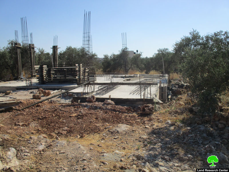
Thursday , 11 ,July 2019 , The Israeli occupation forces accompanied by a vehicle from the civil administration raided ‘Azzun ‘Atma east Qalqilya , and served a notice to a building there on the pretext of building in an area of antiquities.

The targeted area is located to the east of ‘Azzun ‘Atma village , in an area known of “Jather Al-Balad”  that consists of several buildings since 1960, the targeted house belongs to Fayeq Ahmad.

Affected citizen Fayeq Ahmad told LRC reporter:

“ Early July, I started building foundations and installing columns to build a house, but I was shocked when the occupation forces showed up claiming that the location is an antiquities site , were all sorts of constructions are prohibited . Noteworthy, the plot is in B area according to Oslo accords. The occupation gave me only one week to evict the area and return it to its previous status , and refused to license any structures in the plot.”

Photos 1-2: the targeted building

Photo 3: Jather Al-Balad location in ‘Azzun ‘Atma

‘Azzun ‘Atma is witnessing a colonial scheme , acording to the village council there are more than 43 notices in ‘Azzun ‘Atma , and 14 facilities were demolished residential , agricultural and commercial.

About ‘Azzun ‘Atma: [1]

Located 8km to Qalqiliya city with a total area of 9,472 dunums, of which 1,054 dunums are the village’s built-up area, Azzun ‘Atma is inhabited by 2068 people (2017).

The occupation confiscated vast area from the village for the favor of colonization and the apartheid wall; the areas are detailed as follows:

  • 276 dunums were confiscated for Maale Shamron colony that was established in 1980.
  • The segregation wall ate up hundreds of dunums and isolated 1,205 dunums.
  • 417 dunums were confiscated for the bypass road number 55

It should be marked that the vast majority of Azzun lands (6,927 dunums) is classified as area “C” according to Oslo accords; areas that are controlled by the Israeli occupation. The village has zero percentage of area “A” that is under the control of Palestinian Authority. As for other classifications, the village has 2,546 dunums classified as area “B”. (Geographical Information System- Land Research Center)


[1] GIS-LRC


Prepared by

 The Land Research Center
LRC

Recommended For You

“سيطرة من تحت الأرض”, بواقع 108 أمرا عسكريا, سيطرة اسرائيلية على مياه الفلسطينيين في الضفة الغربية المحتلة

by arij
August 12, 2025
0
بواقع 86 أمرا عسكريا – الأوامر العسكرية الإسرائيلية, الأداة الرئيسية للاحتلال الاسرائيلي للسيطرة على المياه الفلسطينية في الضفة الغربية المحتلة

مقدمة، لطالما شكّلت أزمة المياه إحدى القضايا الأكثر صعوبة في الأراضي الفلسطينية المحتلة، إلا أنها في العقود القليلة الماضية اتخذت منحًنا تصاعديًا خطيرًا، حتى بلغت مستويات غير مسبوقة....

Read moreDetails

تهويد صامت بالأمتار: الطريق إلى بني كيديم خطوة نحو الشرعنة الاستيطانية

by arij
July 16, 2025
0
تهويد صامت بالأمتار: الطريق إلى بني كيديم خطوة نحو الشرعنة الاستيطانية

في الثامن عشر من شهر حزيران من العام 2025، تسلّم أهالي بلدتي سعير والشيوخ الواقعتين شمال شرق محافظة الخليل أمراً عسكرياً إسرائيلياً جديداً يقضي بمصادرة 4.8 دونما من...

Read moreDetails

من غير شرعية إلى واقع مفروض, البؤرة الاستيطانية سدي بوعز في رعاية الاحتلال

by arij
July 15, 2025
0

في الثامن من شهر تموز من العام 2025، سلّمت سلطات الاحتلال الإسرائيلي أمرًا عسكريًا جديدًا يقضي بمصادرة أراضٍ فلسطينية وممتلكات خاصة في بلدة الخضر جنوب غرب محافظة بيت...

Read moreDetails

ملاخي هشالوم: أكثر من مجرد بؤرة استيطانية … مشروع تهويد وتوسّع اسرائيلي

by arij
July 10, 2025
0
ملاخي هشالوم: أكثر من مجرد بؤرة استيطانية … مشروع تهويد وتوسّع اسرائيلي

قامت سلطات الاحتلال الإسرائيلي بتاريخ 7 تموز 2025 بنشر أمر عسكري جديد في الضفة الغربية المحتلة، يحمل عنوان: "أمر بشأن الأملاك الحكومية (يهودا والسامرة) (رقم 59) لسنة 1967"....

Read moreDetails

Israeli Order Targets Zububa Village Under Security Claims

by arij
June 24, 2025
0
أمر عسكري إسرائيلي يستهدف أراضي قرية زبوبا الفلسطينية لأغراض أمنية مستعجلة

As part of Israel's systematic violations against Palestinian land in the occupied West Bank", the Israeli occupation authorities, on June 14, 2025, issued a new military order to...

Read moreDetails
Next Post

ARIJ Daily Report – Thu, 11th 07 2019

LATEST NEWS

” المواقع الأثرية في محافظة نابلس… ساحة مفتوحة أمام مخططات المصادرة الإسرائيلية “

” المواقع الأثرية في محافظة نابلس… ساحة مفتوحة أمام مخططات المصادرة الإسرائيلية “

by arij
August 21, 2025
0

........................................................

مشروع (E1): الضربة القاضية لحل الدولتين وإعادة تشكيل الخريطة الجيوسياسية للضفة الغربية

The Government Pushes Forward Plans in E1, Considered a Death Blow to the Two-State Solution

by arij
August 16, 2025
0

........................................................

مشروع (E1): الضربة القاضية لحل الدولتين وإعادة تشكيل الخريطة الجيوسياسية للضفة الغربية

مشروع (E1): الضربة القاضية لحل الدولتين وإعادة تشكيل الخريطة الجيوسياسية للضفة الغربية

by arij
August 16, 2025
0

........................................................

بواقع 86 أمرا عسكريا – الأوامر العسكرية الإسرائيلية, الأداة الرئيسية للاحتلال الاسرائيلي للسيطرة على المياه الفلسطينية في الضفة الغربية المحتلة

“سيطرة من تحت الأرض”, بواقع 108 أمرا عسكريا, سيطرة اسرائيلية على مياه الفلسطينيين في الضفة الغربية المحتلة

by arij
August 12, 2025
0

........................................................

flag_yellow_lowEU-PfP-Logo

This website has been produced with the assistance of the European Union. The contents of this publication are the sole responsibility of ARIJ & LRC and can in no way be taken to reflect the views of the European Union.

© 2025 Copyright ARIJ . All Rights reserved. .

No Result
View All Result
  • Home
  • Settlements
    • New Israeli Settlements
    • Settlement Expansion
  • Israeli Violations
    • Agriculture
    • Confiscation
    • Demolition
    • Environment
    • Eviction of Palestinians
    • Settlers Attacks
  • Bypass Roads
  • Israeli Plans
  • Segregation
    • Checkpoints
    • Closure
    • Separation Plans
  • Military Orders
  • Reports
    • Daily Report
    • Monthly Report
    • Quarterly Report

© 2025 Copyright ARIJ . All Rights reserved. .