• About The Project
  • Palestine in Century
  • Selected Maps
  • Glossary
  • About ARIJ
  • About LRC
  • By Year
    • Case Studies By Year
    • Daily Report By Year
Monday, June 9, 2025
POICA
No Result
View All Result
  • Home
  • Settlements
    • New Israeli Settlements
    • Settlement Expansion
  • Israeli Violations
    • Agriculture
    • Confiscation
    • Demolition
    • Environment
    • Eviction of Palestinians
    • Settlers Attacks
  • Bypass Roads
  • Israeli Plans
  • Segregation
    • Checkpoints
    • Closure
    • Separation Plans
  • Military Orders
  • Reports
    • Daily Report
    • Monthly Report
    • Quarterly Report
No Result
View All Result
POICA
No Result
View All Result

Confiscation of lands for a new colonial road / Hebron

June 13, 2019
in Bypass Roads
Confiscation of lands for a new colonial road / Hebron


  • Violation: confiscation of lands for a new colonial road / order of acquisition and disposal No (19 / 1 / H).
  • Location : Al-Aroub refugees’ camp , Beit Ummar and Halhul villages / Hebron governorate.
  • Date: 03/04/2019.
  • Perpetrators: Head of the civil administration.
  • Victims: land owners in the aforementioned locations.

Description:

The Israeli occupation army issued military order (19/1/H) , signed by the civil administration head “Ahavat Amid” on the confiscation and disposal of about 401 dunums , in order to open a bypass road named (Al-Aroub bypass road) as the military order mentions. The new bypass road will devour hundreds of agricultural dunums in the following locations:

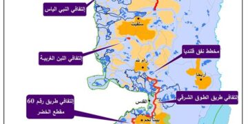
Beit Ummar: Natural block 2 in “Fraidis , Beit Za’ata, Jabal Abu Soda, Jabal Al-Qarn, Wed Ash-Shaikh and natural block 4 “ Wed Al-Aroub”.

Halhul: Natural block 34928 , plots “10,7,23-23,26,37-44,60,71,87-91,39-118,124-126,157,141”.

Natural block 8 in the following locations: Khirbet Beit Kharaf, Ra’as Al-Qadi, Khirnet Al-Durji.

Natural block 10 in Dahr Al-Baw.

Natural block  11 in Wardan location.


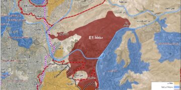
As it is read by the Geographical Information Unit in LRC, the attached map shows that the road will start from  “Kfar Etzion” junction and travel to bypass 60, about 720 meters north An-Nabi Yunis junction.

  • The new road will be about 7.685 km long and 160 m wide, in the following locations:
  • 790 km in Al-Aroub, parts of them are in Palestine technical University – Al-Aroub branch.
  • 652 km in Halhul (625 including a turning road that leads to Karmi Tzur) in these locations: Ras Al-Qadi, Beit Al-Khairan, Wadi Al-Shinar, Ar-Ramuz, Al-Hawawir.

The occupation army posted the military order on a website related to the Israeli government and on Jerusalem newspaper in 10 August 2006.

The military order mentioned the confiscation of 401 dunums, while the attached map shows that the road will devour 1309 dunums of lands from Aroub , Beit Ummar and Halhul. Thus, the towns will be blocked between two bypass roads.

Commentary and appeal:

Israeli measurements for the implementation of this road are in the final phase, and the implementation will commence officially  in the 3rd
of April 2019.

We call for land owners in Halhul, Beit Ummar, Al-Aroub refugee’s camp  and Shuyukh Al-Aroub to head to the Colonization and Wall Resistance commission for legal aid and object on the military order.


Prepared by
 The Land Research Center
LRC

Recommended For You

شق طريق استيطاني جديد يهدد سبل العيش في قرية بردلة

by arij
January 13, 2025
0
New Israeli Settlement Road Construction and Its Impact on the Village of Bardala in the Jordan Valley

المكان: تجمع بردلة- محافظة طوباس/الأغوار الزمان: سبتمبر 2024 الجهة المتضررة: أهالي قرية بردلة والقرى المجاورة الجهة المعتدية: ما تسمى بالإدارة المدنية الاسرائيلية الانتهاك: شق طريق استيطاني تفاصيل الانتهاك:...

Read moreDetails

New Israeli Settlement Road Construction and Its Impact on the Village of Bardala in the Jordan Valley

by arij
December 31, 2024
0
New Israeli Settlement Road Construction and Its Impact on the Village of Bardala in the Jordan Valley

  The construction of new settlement infrastructure in the occupied Palestinian territories has profound implications for local communities, threatening livelihoods, increasing isolation, and impairing socio-economic vulnerabilities. This case...

Read moreDetails

الطرق الالتفافية الاسرائيلية وأثرها على البيئة الفلسطينية

by arij
January 16, 2024
0
الطرق الالتفافية الاسرائيلية وأثرها على البيئة الفلسطينية

  الاعتداءات الإسرائيلية على الفلسطينيين لا تقتصر على التنكيل بالافراد، أو وضع القيود على الحركة والتنقل، أو استهداف المنازل والمنشات، أو مصادرة الأراضي، أو نهب الموارد والمصادر الطبيعية،...

Read moreDetails

Israeli Colonists Take Over an Agricultural Road in Ya’bad town / Jenin Governorate

by arij
January 12, 2022
0
Israeli Colonists Take Over an Agricultural Road in Ya’bad town / Jenin Governorate

  Violation: Taking over an agricultural road for the favor of colonization. Location: Ya’bad town / Jenin Governorate. Date: October 17th 2021. Perpetrators: Mevo Dotan Colony. Victims: Farmers...

Read moreDetails

New Colonial road to Be Opened on Sarta Village lands / Salfit Governorate

by arij
July 17, 2021
0
New Colonial road to Be Opened on Sarta Village lands / Salfit Governorate

  Violation: Opening a new Colonial Roads. Location: Sarta village/ Salfit Governorate. Date: June 1st 2021. Perpetrators: The Israeli Illegal Industrial Colony (Barkan). Victims: Farmers from the village....

Read moreDetails
Next Post
Confiscation of lands for a new colonial road / Hebron

الإعلان عن  قرار بشأن "استملاك وأخذ حق التصرف" لمئات الدونمات الزراعية لصالح شق طريق استعماري بديل على حساب الأراضي الزراعية / محافظة الخليل

LATEST NEWS

ثمانية وخمسون عاما على حرب 1967: تقويض حل الدولتين

ثمانية وخمسون عاما على حرب 1967: تقويض حل الدولتين

by arij
June 5, 2025
0

........................................................

58 Years since the 1967 War: Undermining the Two-State Solution

58 Years since the 1967 War: Undermining the Two-State Solution

by arij
June 5, 2025
0

........................................................

Infographic – The Geopolitics of Area C

ورقة موقف: إسرائيل تصادق على استئناف تسجيل الأراضي في الضفة الغربية

by arij
June 9, 2025
0

........................................................

77 عام  على النكبة الفلسطينية: حاضر مستمر لا تاريخ منتهي

77 عام  على النكبة الفلسطينية: حاضر مستمر لا تاريخ منتهي

by arij
June 2, 2025
0

........................................................

flag_yellow_lowEU-PfP-Logo

This website has been produced with the assistance of the European Union. The contents of this publication are the sole responsibility of ARIJ & LRC and can in no way be taken to reflect the views of the European Union.

© 2025 Copyright ARIJ . All Rights reserved. .

No Result
View All Result
  • Home
  • Settlements
    • New Israeli Settlements
    • Settlement Expansion
  • Israeli Violations
    • Agriculture
    • Confiscation
    • Demolition
    • Environment
    • Eviction of Palestinians
    • Settlers Attacks
  • Bypass Roads
  • Israeli Plans
  • Segregation
    • Checkpoints
    • Closure
    • Separation Plans
  • Military Orders
  • Reports
    • Daily Report
    • Monthly Report
    • Quarterly Report

© 2025 Copyright ARIJ . All Rights reserved. .