• About The Project
  • Palestine in Century
  • Selected Maps
  • Glossary
  • About ARIJ
  • About LRC
  • By Year
    • Case Studies By Year
    • Daily Report By Year
Thursday, July 3, 2025
POICA
No Result
View All Result
  • Home
  • Settlements
    • New Israeli Settlements
    • Settlement Expansion
  • Israeli Violations
    • Agriculture
    • Confiscation
    • Demolition
    • Environment
    • Eviction of Palestinians
    • Settlers Attacks
  • Bypass Roads
  • Israeli Plans
  • Segregation
    • Checkpoints
    • Closure
    • Separation Plans
  • Military Orders
  • Reports
    • Daily Report
    • Monthly Report
    • Quarterly Report
No Result
View All Result
POICA
No Result
View All Result

The Israeli Security Zones make up 45.25% of the West Bank Including 158 Israeli Settlements

June 18, 2002
in Israeli Plans
The Israeli Security Zones make up 45.25% of the West Bank Including 158 Israeli Settlements


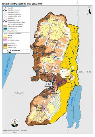
After further inquiry, field work investigation and map analysis, the Applied Research Institute- Jerusalem has succeeded to draw a map of Sharon's actual motive behind his security plan in the West Bank, that of creation of an apartheid system in the territories.

West Bank Map Analysis

Besides the Israeli closure policy imposed on Palestinian town and cities since the beginning of Al-Aqsa Intifada two years ago, the West Bank- according to the new separation policy- will be fragmented into 8 blocks, creating 64 Palestinian ghettos. These ghettos are surrounding by 46 permanent checkpoints and 126 roadblocks. From May 2002, Israel started to implement an apartheid regime, Palestinian residents need special permits issued by the Israeli Civil Administration, Israeli's military government (as those 'passbooks' used in South Africa), for travel between Palestinian cities and cantons within the West Bank and Gaza.

According to Sharon's military plan of separation, the West Bank will be divided into three longitudinal slices: Western-Northern Security Slice, Eastern Security Slice and the Remaining Palestinian areas in the middle. See map

  • The Western-Northern Security Slice (red in map)- extends alongside the 'Green line' from the Palestinian city of Jenin in the northern boundaries of the West Bank down to Hebron in the south. This security zone has a total area of 1328 Km2, which is 23.4% of total area of the West Bank. Also, it will enclose 118 Israeli settlements.

  • The Eastern Security Slice (yellow in map)- includes the Jordan Valley and the shores of the Dead Sea with a total area of 1237 Km2 (21.9 % of the West Bank); 40 Israeli settlements are included within boundaries of this zone.

  • The Remaining Palestinian area– includes main urban Palestinian cites (Area A) and part of Area B. This area is already fragmented into 64 ghettos, surrounded by 46 Israeli permanent checkpoints and 126 roadblocks. The total area of this fragmented region is 3096 Km2, which amounts to 54 % of the total area of the West Bank.  The table below summarizes the above-mentioned data:

Total area of the Security zones

2565 Km2 (45.25 % of West Bank Total Area)

Total area of the remaining Palestinian area

3096 Km2

Total number of Israeli settlements inside the security zones

158 (-out of 223 Israeli settlements)

Palestinian population inside security zones

267,700* (17 % of total Palestinian population in the West Bank)

 Source: Applied Research Institute, GIS Database, 2002

*1997 Palestinian Census (Palestinian Central Bureau of Statistics).


Prepared by:
The Applied Research Institute – Jerusalem

Recommended For You

ورقة موقف: إسرائيل تصادق على استئناف تسجيل الأراضي في الضفة الغربية

by arij
June 9, 2025
0
Infographic – The Geopolitics of Area C

اعداد: د. جاد اسحق، ناصر الريس وسهيل خليلية صادق المجلس الوزاري المصغر الإسرائيلي (الكابينيت) بتاريخ 26/1/2025، على قرار استئناف تسجيل ملكية الأراضي في المنطقة (ج) من الضفة الغربية...

Read moreDetails

Israel Advances Settlement Plan on Ancient Olive Groves on lands of Beit Jala city, Violating International Law and depriving Palestinians their lands

by arij
April 29, 2025
0
Israel Advances Settlement Plan on Ancient Olive Groves on lands of Beit Jala city, Violating International Law and depriving Palestinians their lands

  In late February 2025, Israel has approved a new settlement construction plan on 22.2 dunums of privately owned Palestinian land in the city of Beit Jala, south...

Read moreDetails

Leveraging the Olmert Plan to Safeguard Palestinians amid US Displacement Plans of Gazans to Egypt and Jordan

by arij
February 5, 2025
0
Leveraging the Olmert Plan to Safeguard Palestinians amid US Displacement Plans of Gazans to Egypt and Jordan

  After the ceasefire in the Gaza Strip took effect on January 19, 2025, U.S. President Donald Trump made a highly inhumane statement on January 26, 2025, suggesting...

Read moreDetails

محمية وادي قانا في وجه التهديد الاسرائيلي

by arij
March 26, 2024
0
محمية وادي قانا في وجه التهديد الاسرائيلي

  ان الحرب الإسرائيلية المسعورة ليست محصورة في قطاع غزة المحتل فقط، بل تمتد آثارها إلى الضفة الغربية المحتلة حيث لا تنفك سلطات الاحتلال الإسرائيلي عن استهداف الضفة...

Read moreDetails

إسرائيل تقرر بناء جدار على الحدود الشرقية مع المملكة الأردنية الهاشمية

by arij
October 19, 2023
0
From conflict Resolution to Conflict Management

  انتهاك للسيادة الاردنية وتعزيز السيطرة على الاراضي الفلسطينية وترسيخ الحدود أعلن رئيس وزراء الاحتلال الإسرائيلي في الثالث من شهر أيلول من العام 2023 عن قراره بناء سياج...

Read moreDetails
Next Post
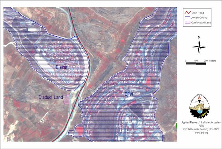
Agricultural Land confiscation Near Elazar Settlement

Agricultural Land confiscation Near Elazar Settlement

LATEST NEWS

Striking Wave of Escalating Settler Attacks and Forced Displacement in the Palestinian Jordan Valley

Striking Wave of Escalating Settler Attacks and Forced Displacement in the Palestinian Jordan Valley

by arij
July 3, 2025
0

........................................................

تصاعد اعتداءات المستوطنين وعمليات التهجير القسري في الأغوار الفلسطينية

تصاعد اعتداءات المستوطنين وعمليات التهجير القسري في الأغوار الفلسطينية

by arij
July 3, 2025
0

........................................................

أمر عسكري إسرائيلي يستهدف أراضي قرية زبوبا الفلسطينية لأغراض أمنية مستعجلة

Israeli Order Targets Zububa Village Under Security Claims

by arij
June 24, 2025
0

........................................................

أمر عسكري إسرائيلي يستهدف أراضي قرية زبوبا الفلسطينية لأغراض أمنية مستعجلة

أمر عسكري إسرائيلي يستهدف أراضي قرية زبوبا الفلسطينية لأغراض أمنية مستعجلة

by arij
June 21, 2025
0

........................................................

flag_yellow_lowEU-PfP-Logo

This website has been produced with the assistance of the European Union. The contents of this publication are the sole responsibility of ARIJ & LRC and can in no way be taken to reflect the views of the European Union.

© 2025 Copyright ARIJ . All Rights reserved. .

No Result
View All Result
  • Home
  • Settlements
    • New Israeli Settlements
    • Settlement Expansion
  • Israeli Violations
    • Agriculture
    • Confiscation
    • Demolition
    • Environment
    • Eviction of Palestinians
    • Settlers Attacks
  • Bypass Roads
  • Israeli Plans
  • Segregation
    • Checkpoints
    • Closure
    • Separation Plans
  • Military Orders
  • Reports
    • Daily Report
    • Monthly Report
    • Quarterly Report

© 2025 Copyright ARIJ . All Rights reserved. .