Residents of Al Issawiya village in Jerusalem Governorate were taken by surprise during the last week of September 2004 when a group of Israel's Land Authority employees placed a number of signs on a 250-dunums piece of land declaring it as a ''State Land.'' The land, currently inaccessible to the villagers, is located north of Shu'fat-Jericho road which also leads to the settlement of Ma'ale Adumim located east of Jerusalem. A week later, Israeli bulldozers surrounded the besieged area by a sandy road in a way to connect the 'already-posted signs'. The confiscated land is located in Parcel No. 4 of the village's lands which are composed of 7 parcels containing the village's total area (12,000 dunums).
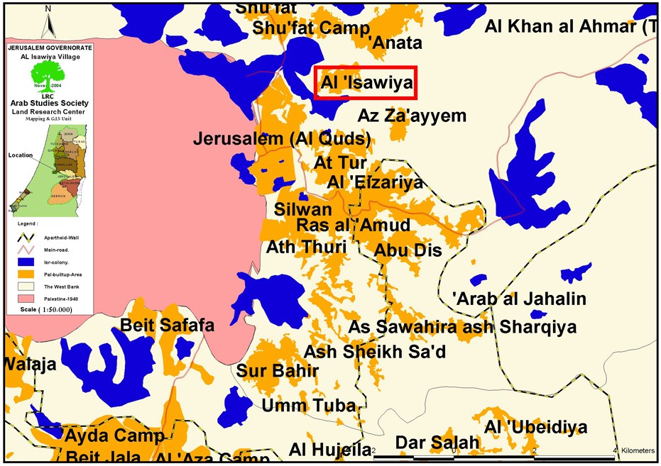
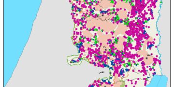
( map 1- location of Issawiya village)
Land owners asserted that Israeli official, without any prior notice, confiscated the land and indicated that controlling these lands separates villages' lands located to the west of Shu'fat-Jericho bypass Road from those located to the east of the Road. It is worth mentioning here that Israeli occupation authorities declared in 1985 all ''unused lands'' as 'State Lands' through the manipulative use of the Ottoman Land Law of 1858 (hereafter ''the Land Law') which was valid within Israel until its replacement in 1970 by a different law passed by the Knesset, The Lands Law, 5729-1969. Lands were confiscated despite the fact that all land owners in Al Issawiya village have all the necessary documents that prove their ownership of the lands.
Deliberate Obstacles:
The villagers resorted to a number of lawyers to file legal cases against the confiscation of their lands. As to hamper their efforts, Israeli financial institutions have placed obstacles in the way of land owners as to prevent them from obtaining the needed official documents. One such obstacle is the condition set by these institutions that whoever wants to issue any official document has to pay all taxes incurred in the past years on the land. A case in point is what took place to Mr. Khaled Sabri Darwish who was trying to issue document of ownership to a 1.5 dunums land. The relevant Israeli institution requested that he provides an Inheritance Declaration for his grandfather and another one for his father as well as paying the sum of NIS 148,000 as taxes !!!!!.
Israeli Colonial Expansion on the Expense of Al Issawiya Village:
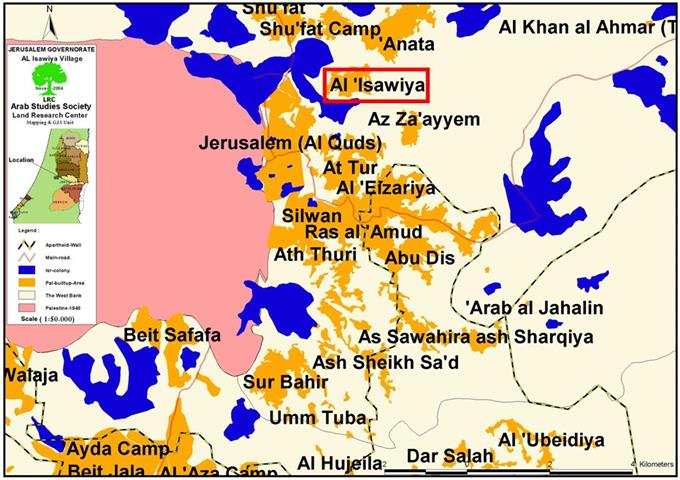
The targeted 250 dunums are needed by Israel to continue its Eastern Gate Project that connects Ma'ale Adumim and the French Hill settlement at the heart of Jerusalem city. These lands are located between Al Issawiya's eastern entrance and the village of Al Za'ayem located to the east of Al Issawiya. These lands are added to more than 3,000 dunums confiscated earlier for the sake of Ma'ale Adumim settlement. The Israeli plan calls for the geographical continuity between Mishor Adumim, Al Khan Al Ahmar settlements, the Israeli queries located on Abu George Street, Anatot, Almon, Anata and Hizma as indicated by location number 3 on the attached aerial photo.
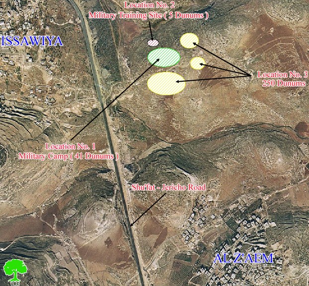
(aerial photo 1- confiscated locations)
Speaking to LRC field worker, Mr. Hani Al Issawi, a land owner from the village, pointed out that the eastern section (between 'Anata and the tunnel of the Mount of Olives) of the Eastern Gate Project is planned to go through 1 kilometer in Al Issawiya village land. So far, half kilometer has been constructed causing a loss of 50 dunums of Issawiya village lands.
Another incident that shows the Israeli determination to confiscate as much land as possible from Al Issawiya village land is what happened with Mr. Ziad Al Issawi who received a military order stating the confiscation of 500 square meters of his land located northeast Mizadot Adumim military camp. The military order gave the land owner only 7 days to object to the decision which he did through his lawyer. The appeal was rejected based on a statement by Israeli officials that the land is confiscated for a temporary period of time. ( See location number 2 on the attached aerial photo). ).
The tragedy took place when the Israeli forces came to execute the order. Instead of bulldozing the 500 m2 as indicated in the Military Order, they bulldozed 5,000 m2 (ten times the area dictated by the Order).
False Israeli Promises:
It must be reported that in April 2002 Israeli authorities issued a confiscation order of 41 dunums that belonged to Al Issawiya village under the pretext that the land is to be used for establishing a temporary checkpoint. Land owners (from the Dari and Derbas families) filed an appeal against the confiscation order at the Israeli High Court which issued on 18/7/2002 an order allowing the establishment of the checkpoint for one renewable year if the current security situation was to continue. The court decision also obliged the Israeli military to pay an annual rent for the land, and allowed land owners to access the rest of the land at their leisure. ( See location number 1 the on the attached aerial photo). ).
The decision was a big lie since the 500 m2 land was duplicated to 5000 m2. The checkpoint which was supposed to be temporary one, was transformed into a permanent cement castle, not only for one year as stipulated by the Court's decision.
Dividing the Village into parts:
It is obvious that the village of Al Issawiya and its lands has been a prime target for Israeli expansion; 800 dunums of its lands were confiscated for the purpose of the expanding the Hebrew University, Hadasah Hospital and the Israeli military camp built at the southern outskirts of the village. Moreover, a military order was issued preventing Palestinians from constructing more than two floors or from planting trees more than 1.5 meters high in a radius of 500 meters from the checkpoint. This meant the prevention of house construction in the southern half of the village which led to the demolishing of a number of houses. Furthermore, the Israeli occupation forces have confiscated in the past 600 dunums of the villages' lands for the purpose of expanding the French Hill settlement and established a bypass road that divided the village into two parts:
The First part is located to the east of the bypass road and reaches as far as the Al Khan Al Ahmar with an area of 10,000 dunums. This half is classified as ''West Bank Lands''. About 3,000 dunums of this half were confiscated for future expansion of Ma'ale Adumim settlement while Jerusalem Municipality kept to itself the right to use an area along the bypass road with a depth of 150 to 200 meters inside the village.
The Second Half is located to the west of the bypass road of an area of 2,000 dunums, only 680 dunums of which can be used for the village's Master Plan. The remaining dunums which were left outside the Master Plan zone has many houses built on it without proper licenses to confront the ever-increasing housing demands as more than 40 houses were demolished in the village.
The Israeli practices against the village of Al Issawiya (including land confiscation, house demolition and other racist measures) aim at Judaizing Jerusalem city and preventing the natural expansion of the village.
Prepared by
The Land Research Center
LRC