• About The Project
  • Palestine in Century
  • Selected Maps
  • Glossary
  • About ARIJ
  • About LRC
  • By Year
    • Case Studies By Year
    • Daily Report By Year
Tuesday, August 4, 2026
POICA
No Result
View All Result
  • Home
  • Settlements
    • New Israeli Settlements
    • Settlement Expansion
  • Israeli Violations
    • Agriculture
    • Confiscation
    • Demolition
    • Environment
    • Eviction of Palestinians
    • Settlers Attacks
  • Bypass Roads
  • Israeli Plans
  • Segregation
    • Checkpoints
    • Closure
    • Separation Plans
  • Military Orders
  • Reports
    • Daily Report
    • Monthly Report
    • Quarterly Report
  • Home
  • Settlements
    • New Israeli Settlements
    • Settlement Expansion
  • Israeli Violations
    • Agriculture
    • Confiscation
    • Demolition
    • Environment
    • Eviction of Palestinians
    • Settlers Attacks
  • Bypass Roads
  • Israeli Plans
  • Segregation
    • Checkpoints
    • Closure
    • Separation Plans
  • Military Orders
  • Reports
    • Daily Report
    • Monthly Report
    • Quarterly Report
No Result
View All Result
POICA
No Result
View All Result

Turning an agricultural area into a closed archaeological site in Fasayil El-Wista

May 4, 2014
in Israeli Plans
Turning an agricultural area into a closed archaeological site in Fasayil El-Wista


Violation:  agricultural lands adjoined to archeological site in Jericho
Date: May 04, 2014
Location: Fasayil el-Wista
Perpetrators: Civil Administration of the Israeli occupation
Victims: residents of the village

Details:

The village has always been a target for colonial plans. 17 km away from Jericho, the villagers have not been safe from the expelling attempts that in this regard served at the so called the Jordan Valley Annexation to the state of Israel.

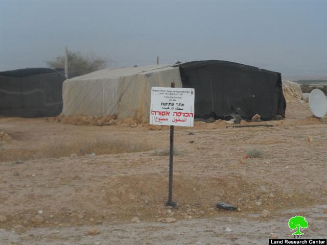
It is marked that the Ministry of Tourism and Antiquities pined directory signs stating “an inaccessible archeological site” written in Hebrew and Arabic in the southern part of Fasayil el-Wista. Noteworthy, the aforementioned area is located nearby the bypass road no.90 and is considered a shelter for Bedouins for what it has of land fertility spread on 50dunums which is in other words the only source of living available for residents.

The legal consultant of Jericho governorate Mr Hani Zoubidat, in regard to the occupation plan, stated: “in the beginning of the current year, the occupation embarked unidentifiable excavation works in the village where all roads were shut down as a result. The pretext came under finding some archeological antiquities in the area that the occupation most probably refers to them as Jewish.


Photos 1-2: the pined directory signs

Zoubidat also added: “the only victim in this process is the residents of the village for the occupation took over their fertile agricultural lands. The ravaging acts gave the occupation the chance to expel around 680 Bedouin residents. Noteworthy, the occupation denied the residents of the village as opposed to the village itself”.

 Additionally, Jericho minister of Local Government , Ismael Abu Khrabish to LRC asserted that: “Israel raced time to distort facts and history and to loot the natural resources of the Palestinian al-Ghoor for the favor of Judaizing the area. The occupation aimed at convincing the world that it had a history in this very place which would justify its presence in al-Ghoor areas. In synchronization with the aforementioned, the occupation continued confiscating lands, expelling people out of their homes and banning them from using these lands. The core of that intense plan was implemented in the village of Fasayil.

 It is notable that the targeted area totals around 50 agricultural dunums  that are inhabited by six Bedouin families destined to forcefully leave their residences.

About the town:

Fasayil is an object of recurrent demolition and evacuation operations by the Israeli occupation. They are also deprived from the basic services like water and electricity. They are forced to buy water, 15 NIS for a 1 m3 . People of Fasayil are drained by poverty, hunger and the nonstop Israeli attacks.

Fasayil is 23 km north of Jericho and its built-up area is 194 dunums only.

It has a population of 1132 (according to Palestinian Central Bureau of Statistics in 2010). It is surrounded by a number of illegal Israeli colonies that limit the expansion of the village and deprive its inhabitants from having a normal life. 

From the north, Fasayil is surrounded by colonies of Yafit and Pezael (Fezael), Tomer and Gilgal and Netiv Hagedud from the south in addition to a bypass that links the northern colonies with the southern ones. 


Prepared by
The Land Research Center
LRC

Recommended For You

إقرار مخطط توسعي رئيسي في مستوطنة تقوع شرق بيت لحم

by arij
July 28, 2026
0
إقرار مخطط توسعي رئيسي في مستوطنة تقوع شرق بيت لحم

"تستهدف 6000 دونما من الأراضي الفلسطينية" صادقت الهيئة العامة لما يسمى "بالمجلس الإقليمي لمستوطنات غوش عتصيون" جنوب الضفة الغربية المحتلة في العشرين من شهر تموز من العام 2026...

Read moreDetails

تستهدف 6000 دونما من الأراضي الفلسطينية وشرعنة ستة مستوطنات جديدة
إقرار مخططات توسعة رئيسية في تجمع غوش عتصيون الاستيطاني جنوب الضفة الغربية المحتلة

by arij
July 22, 2026
0
تستهدف 6000 دونما من الأراضي الفلسطينية وشرعنة ستة مستوطنات جديدة  إقرار مخططات توسعة رئيسية في تجمع غوش عتصيون الاستيطاني جنوب الضفة الغربية المحتلة

صادقت الهيئة العامة لما يسمى "بالمجلس الإقليمي لمستوطنات غوش عتصيون" جنوب الضفة الغربية المحتلة في العشرين من شهر تموز من العام 2026 على مخطط هيكلي استيطاني واسع النطاق...

Read moreDetails

الآثار كأداة للضم الزاحف: مشروع القانون الإسرائيلي لإعادة هندسة الجغرافيا والهوية في الضفة الغربية

by arij
May 23, 2026
0
الآثار كأداة للضم الزاحف: مشروع القانون الإسرائيلي لإعادة هندسة الجغرافيا والهوية في الضفة الغربية

في خطوة تعكس تصاعد المساعي الإسرائيلية لإحكام السيطرة على الرواية التاريخية والجغرافيا الثقافية في الضفة الغربية، صادقت الهيئة العامة لـ الكنيست الإسرائيلي يوم 11 أيار 2026 على مشروع...

Read moreDetails

ذكرى الـ 50 ليوم الأرض: فلسطين بين ذاكرة الدم وصمود البقاء    

by arij
April 16, 2026
0

في الثلاثين من آذار، لا يستحضر يوم الأرض في الوعي الفلسطيني بوصفه مناسبة رمزية عابرة، بل كحدث تأسيسي متجدد يعكس استمرارية الصراع على الأرض والهوية. وبعد مرور خمسين...

Read moreDetails

Unprecedented Acceleration in Israeli Settlement Expansion in 2025

by arij
March 25, 2026
0
Unprecedented Acceleration in Israeli Settlement Expansion in 2025

Preface, The Israeli settlement policy in the occupied West Bank is one of the most significant obstacles to achieving a just and sustainable peace. Since the occupation of...

Read moreDetails
Next Post
الانتهاكات الإسرائيلية في القدس المحتلة خلال شهر نيسان من العام 2014

الانتهاكات الإسرائيلية في القدس المحتلة خلال شهر نيسان من العام 2014

LATEST NEWS

” 118 ألف دونم مهددة بالعزل في محافظة طوباس”  إسرائيل تستكمل مشروع “الخط القرمزي” وتوسع عزل الأراضي الفلسطينية شرق الضفة الغربية المحتلة

” 118 ألف دونم مهددة بالعزل في محافظة طوباس”
إسرائيل تستكمل مشروع “الخط القرمزي” وتوسع عزل الأراضي الفلسطينية شرق الضفة الغربية المحتلة

by arij
July 29, 2026
0

........................................................

إقرار مخطط توسعي رئيسي في مستوطنة تقوع شرق بيت لحم

إقرار مخطط توسعي رئيسي في مستوطنة تقوع شرق بيت لحم

by arij
July 28, 2026
0

........................................................

تستهدف 6000 دونما من الأراضي الفلسطينية وشرعنة ستة مستوطنات جديدة  إقرار مخططات توسعة رئيسية في تجمع غوش عتصيون الاستيطاني جنوب الضفة الغربية المحتلة

تستهدف 6000 دونما من الأراضي الفلسطينية وشرعنة ستة مستوطنات جديدة
إقرار مخططات توسعة رئيسية في تجمع غوش عتصيون الاستيطاني جنوب الضفة الغربية المحتلة

by arij
July 22, 2026
0

........................................................

“حتى النصف الأول من العام 2026 “, ” الاستيطان يلتهم الأرض الفلسطينية: ما يزيد عن 22 ألف دونم مستهدفة و 19 ألف وحدة استيطانية”

“حتى النصف الأول من العام 2026 “, ” الاستيطان يلتهم الأرض الفلسطينية: ما يزيد عن 22 ألف دونم مستهدفة و 19 ألف وحدة استيطانية”

by arij
July 22, 2026
0

........................................................

flag_yellow_lowEU-PfP-Logo

This website and its content were initiated in 1993 by the Applied Research Institute – Jerusalem (ARIJ) and the Land Research Center (LRC) with the support from the European Union up until 2023. Since then, the Applied Research Institute – Jerusalem (ARIJ) has taken over the continued development and maintenance of the website. The views expressed remain solely those of ARIJ) and do not necessarily reflect those of the European Union.

© 2026 Copyright | ARIJ | All Rights reserved.

No Result
View All Result
  • Home
  • Settlements
    • New Israeli Settlements
    • Settlement Expansion
  • Israeli Violations
    • Agriculture
    • Confiscation
    • Demolition
    • Environment
    • Eviction of Palestinians
    • Settlers Attacks
  • Bypass Roads
  • Israeli Plans
  • Segregation
    • Checkpoints
    • Closure
    • Separation Plans
  • Military Orders
  • Reports
    • Daily Report
    • Monthly Report
    • Quarterly Report

© 2026 Copyright | ARIJ | All Rights reserved.