On the 27th of January 2016, the Israeli Jerusalem Municipality’s Planning Committee approved a plan to construct a new light rail line that will link some of the city’s more peripheral neighborhoods to the city’s center with each other.
According to the Israeli Resources, the new light Rail path (Blue Line), will connect the Israeli settlement of Gilo, which located south of Jerusalem city, to the Israeli Settlement of Ramot, at the northern part of the city. The new path length will be about 20 kilometers (over 12 miles) and will serve some 250,000 passengers.
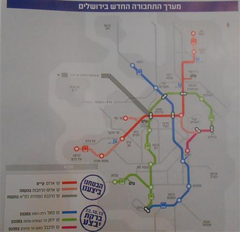
Moreover , the so-called Blue Line route will begin on the southern part of Jerusalem city, in the Israeli settlement of Gilo, pass through Jerusalem city center and ends at Ramot settlement, at the northern part of the city. On the other hand the second Blue line route will start at the neighborhood of Malha, stretching through Emk Refaim and the Jerusalem Khan Theater, and end in Ramot as well. (See the map No.1)
Map No.1: The Route of the Jerusalem Light Rail
The Blue line is expected to serve some 250,000 passengers, and will complement the current Red line of the Light Rail system, which starts from the Israeli settlement of Pisgat Ze’ev, in the north, passing through Ammunition Hill, and ends to its current stop at “Mount Herzl”, in the south.
It’s just the First step….. Future lines for the Light rail in Jerusalem city
In September 2013, the Israeli daily newspaper, Haaretz, reported that the Israeli Jerusalem Municipality is adding new stop to the Jerusalem light rail to increase the number of travelers. And for doing so, the Jerusalem light rail system will be expanded to include another five lines over the next 20 years, under a plan being drafted by Jerusalem city hall and the Israeli Ministry of Transportation.
Accordingly, the railway has been expanded from Pisgat Ze’ev settlement up to Neveh Yaakov settlement in the north, and from Mount Herzl to Tahun Junction in the south by the year 2016, and later from Tahun to Ora Junction. It also calls for beginning a line from Herzl Boulevard to the Givat Ram campus via the government compound (the “campus line”).
Ultimately, the red line is to end at Hadassah University Hospital, Ein Karem, by 2019. The campus line is to be completed by 2020, passing through Hebrew University’s Mount Scopus campus (known as Jabal Al Masharef) via Hadassah Mount Scopus and linking up to the red line. The total budget of these expansions is around NIS 23 Billion. These expansions to the red line will take it from the existing 9 kilometers up to 23 kilometers, at an expected cost of NIS 2.5 billion. All the extensions to the red line have statutory approval with the exception of the Mount Scopus stops.
Work on additional lines would begin in the decades that follow. The green line would go from the Mount Scopus campus via French Hill, Eshkol Boulevard, the central bus station and Givat Ram, ending in the settlement of Gilo . Statutory planning for this line started at the end of 2013. The blue line will go from Ramot settlement to Gilo settlement, with a fork out to Malha neighborhood. These two lines are supposed to be completed by 2025, at an investment of NIS 12 billion.
According to what is planned by the Israeli authorities ,the final part of the plan is still being reviewed, and calls for adding another three lines – a brown line in East Jerusalem, a purple line from Ein Karem to Talpiot via Malha, and another line from the Kotel to Givat Ram via the city center. These lines would cost an estimated NIS 8.5 billion to build.
Israeli projects towards the “Greater Jerusalem”
After the Israeli occupation of the Palestinian territory in 1967, the Israeli successive governments worked to isolate “the city of Jerusalem” by a mass of projects that aimed to change the demographic situation in the city, by constructing an illegal settlements belt that encircled the city.
Throughout the years of the occupation, the Israeli Occupation Authorities proceeded to bring the Israeli settlers to live in Jerusalem city, and worked as well to implement a number of colonial projects at the eastern part of Jerusalem city. In the year 2002, after the Israeli Authorities decided to construct the “Segregation Wall”, the Israeli intention became more pronounced, where by the construction of Segregation Wall, the Israeli Authorities isolated Jerusalem city from the nearby Palestinian cities and towns and Governorates, while increase the area of “Jerusalem city” by unilateral re-drawing of the boundaries of the city, and annexed three illegal settlement blocks to the border of Jerusalem city (Givat Ze’ev, Ma’aleh Adumim and Gush Etzion). Following the completion of the construction of the Segregation Wall the Israeli Authorities will put about 12 Palestinian villages and towns outside the border of Jerusalem city.
|
The changing of the Jerusalem Municipality Boundaries |
|
|
Year |
Area |
|
Before 1967 |
6.5 k.m2 |
|
After 1967 |
71 k.m2 |
|
Currently and with Segregation Wall |
246.5 k.m2 |
These Israeli projects, such as building the illegal settlements, occupying Palestinians houses in the old city of Jerusalem and other strategic sites in the city, established new Jewish plots in the city. Furthermore ,the light rail as well, all of these projects will change the Palestinian identity of the city, and benefit the one and only goals for the Israeli Authorities….. “Greater Jerusalem”, with Jewish dominance, geopolitically and demographically.
The light Rails project like many other projects is hiding behind a political and colonial dimensions and desires and for the favor of the Israeli settlement enterprise in all of the Palestinian Territory and in East Jerusalem in specific.
To sum up
The Israeli Light rail in Jerusalem city, is another illegal Israeli colonial project since it lies in the Territories occupied by the Israeli Authorities in the year 1967. The Israeli expropriation of the Palestinian lands, construction the segregation wall and settlements, and implemented colonial projects in the occupied Palestinian territory constitute a flagrant and grave breach for the International law rules and conventions (Art. 51 of the 1949 Geneva Convention II –Art. 147 of the 1949 Geneva Convention IV- Art. 53 of the 1949 Geneva Convention IV-Art. 23(g) of the 1899 Hague Regulations – the Universal Declaration of Human Rights Adopted and proclaimed by General Assembly resolution 217 A (III) of, December 10, 1948, Articles 13 and 17 and Article 12 of the International Covenant on Civil and Political Rights, adopted by the General Assembly of the United Nations on 19 December 1966 :-
Articles 147 of the Fourth Geneva Convention indicated that: Extensive destruction and appropriation of property not justified by military necessity and carried out unlawfully and wantonly. is a grave breach of the Convention.
Art. 23 of the Hague Convention of 1907 also provides: In addition to the prohibitions provided by special Conventions, it is especially forbidden to destroy or seize the enemy's property, unless such destruction or seizure be imperatively demanded by the necessities of war;.
Article 53 of the same convention provides that 'any destruction by the Occupying power of real or personal property belonging individually or collectively to private persons, or to the State, or other public authorities or social or cooperative organizations is prohibited, except where such destruction is rendered absolutely necessary by military operations.'
Article 147 of the convention considers 'extensive destruction and appropriate of property, not justified by military necessity and carried out unlawfully and wantonly' as a grave breach of the Convention and thus constitute a war crime.
Under the Universal Declaration of Human Rights Adopted and proclaimed by General Assembly resolution 217 A (III) of, December 10, 1948, Article 17 reads: 'No one shall be arbitrarily deprived of his property.' Which means it bans Israel from destroying or confiscating the property of the Palestinians at any case.
Prepared by:
The Applied Research Institute – Jerusalem


