• About The Project
  • Palestine in Century
  • Selected Maps
  • Glossary
  • About ARIJ
  • About LRC
  • By Year
    • Case Studies By Year
    • Daily Report By Year
Monday, October 13, 2025
POICA
No Result
View All Result
  • Home
  • Settlements
    • New Israeli Settlements
    • Settlement Expansion
  • Israeli Violations
    • Agriculture
    • Confiscation
    • Demolition
    • Environment
    • Eviction of Palestinians
    • Settlers Attacks
  • Bypass Roads
  • Israeli Plans
  • Segregation
    • Checkpoints
    • Closure
    • Separation Plans
  • Military Orders
  • Reports
    • Daily Report
    • Monthly Report
    • Quarterly Report
No Result
View All Result
POICA
No Result
View All Result

Bethlehem 59 !!!

February 25, 2004
in Checkpoints
Bethlehem 59 !!!

This is the number of all forms of barriers that restrain Bethlehem district. The district which lay on 608 Km2 (235 M2) and accommodates 170,000 Palestinians, was confined by the Israeli Army over the past three years of the current Intifada which broke out in September 2000.


At that time, Bethlehem district had only 2 permanent checkpoints located at the district outskirts on the entry points to Jerusalem. The barriers multiplied over the past three years to reach a record of 59 barriers classified as illustrated in the following table.


Classification of barriers in Bethlehem District

Classification

Number of barriers

Earth Mound

39

Gates

4

Permanent

7

Roadblock

5

Temporary

4

Total

59


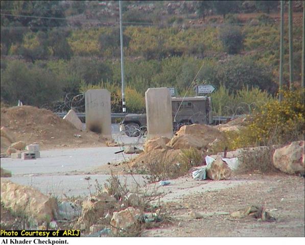
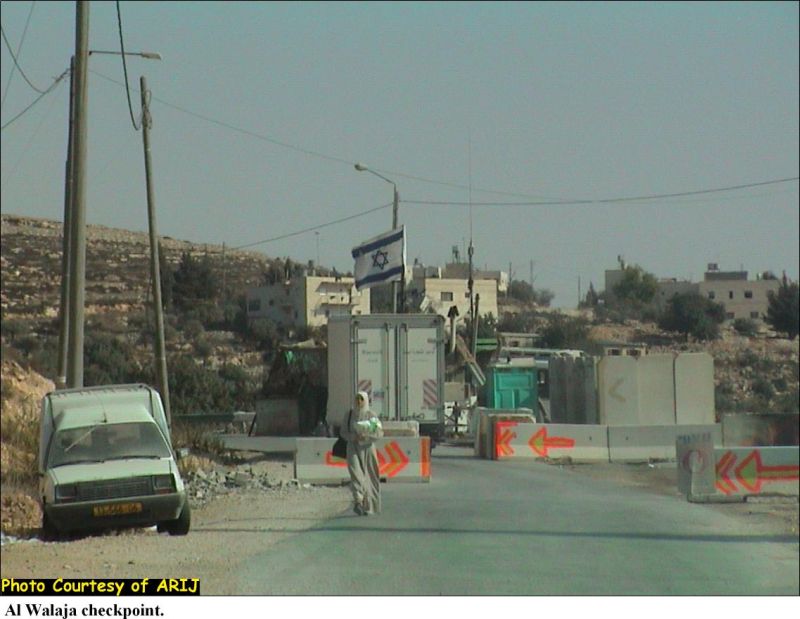
See pictures of checkpoints in Bethlehem, Al Khader and Al Walaja villages.


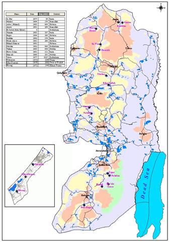
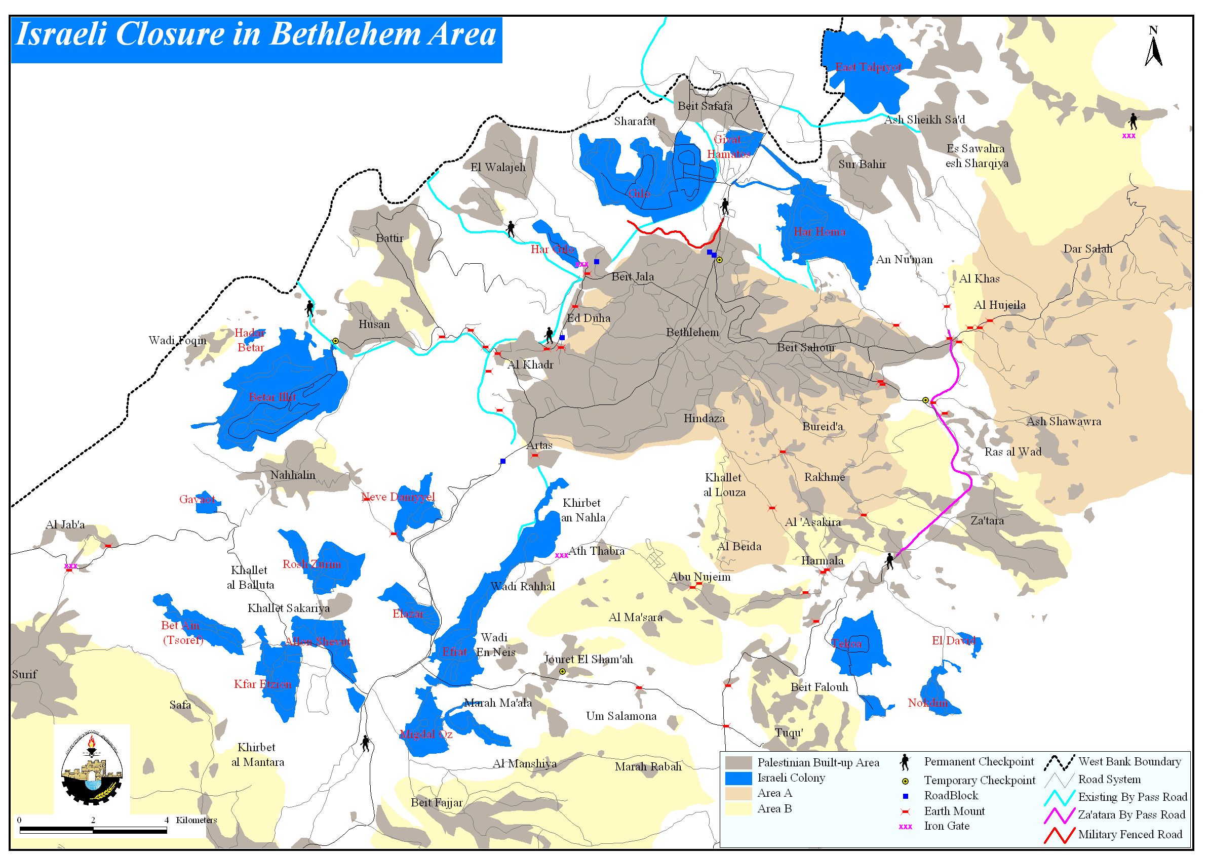
The increased number of barriers that surround and confine Bethlehem district (1 barrier for every 10.5 Km2 (4 M2) has caused a tremendous burden to the lives of the residents in the district. The barriers also contributed to isolate the western and eastern rural areas from the urban center of the district. See map of Checkpoints


The barriers had also impediment effect on the commercial and health sectors as merchandise and agricultural crops had hard time coming to the center of the district or to the main markets. The Israeli settlers and Army also contributed to damage the agricultural lands in the district, which resulted, to an overall estimated loss exceeding 40 million USD during the past three years.


The health sector was also affected. Several deaths were recorded on the checkpoints surrounding Bethlehem districts as the Israeli Army denied access to Palestinian patients to East Jerusalem hospitals for proper medical care. A number of childbirth were also recorded on checkpoints were the Army refused ambulances access to hospitals in East Jerusalem. The 50 km segregation wall constructed by Israel in Bethlehem district came to compliment the barriers in and around the district as it segregate 70 Km2 of Palestinian lands and place it under Israeli jurisdiction for the Army and the Israeli settlers' benefits. The greater parts of the segregated areas are agricultural lands in addition to areas confiscated by Israel to built 22 Israeli settlements. Other areas classified for military use only or designated as military closed areas.  


Related Case Studies:


  • Humiliation at the Israeli military Checkpoints
  • Cutting the northern arteries of the West Bank
  • The Israeli Checkpoints in the Northern Districts of the West Bank …


Prepared by:
The Applied Research Institute – Jerusalem

Recommended For You

عقاب جماعي يومي: الفلسطينيون تحت هيمنة الحواجز العسكرية

by arij
September 24, 2025
0
عقاب جماعي يومي: الفلسطينيون تحت هيمنة الحواجز العسكرية

تشهد الضفة الغربية المحتلة واقعًا خانقًا نتيجة السياسات الإسرائيلية المتمثلة بفرض المزيد من الحواجز العسكرية اليومية والإغلاقات، والتي باتت أداة منهجية للسيطرة والتحكم بحياة الفلسطينيين اليومية، وليست مجرد...

Read moreDetails

الحرب على قطاع غزة وتأثيرها على محافظة الخليل جنوب الضفة الغربية

by arij
November 30, 2023
0

  تقع محافظة الخليل في الجزء الجنوبي من الضفة الغربية المحتلة، إلى الجنوب من مدينة القدس، وعلى بعد حوالي 36 كم منها. يحدها من الشمال محافظة بيت لحم،...

Read moreDetails

تطبيق سياسة الفصل العنصري على استخدام الطرق الرئيسية في الضفة الغربية وتقيد حركة وتنقل المواطنين الفلسطينيين

by arij
November 22, 2023
0
معاناة شجرة الزيتون الفلسطينية بسبب الاحتلال والاستيطان في العام 2023

  بناء على تقديرات مراقبين دوليين يبلغ عدد الحواجز الإسرائيلية في الضفة الغربية أكثر من 567 حاجز إسرائيلي متعددة الاشكال منها 77 حاجزًا رئيسيًا وجزئي تتحكم في حركة...

Read moreDetails

The Instigation of Apartheid Roads Era: Israel blocks Palestinian movement inside West Bank Governorates

by arij
November 22, 2023
0

  According to international observers, Israel constrains the West Bank territory with 567 various types of obstacles; 77 of which are main checkpoints and partial checkpoints that control...

Read moreDetails

Between “Ben Gavir” and Netanyahu Not Oblivious but Vindictive, The reality of Israeli Apartheid Stands in the occupied Palestinian territory

by arij
September 13, 2023
0
Between “Ben Gavir” and Netanyahu Not Oblivious but Vindictive, The reality of Israeli Apartheid Stands in the occupied Palestinian territory

  In the wake of the overwhelming Israeli settlers and the Israeli occupation government increasing their wave of attacks and assaults on the Palestinian people (more than 700...

Read moreDetails
Next Post
To Pullout from Gaza !!! A Daring Step or Just a Tactical One

To Pullout from Gaza !!! A Daring Step or Just a Tactical One

LATEST NEWS

محافظة أريحا على خريطة المصادرة الإسرائيلية- إسرائيل تسعى للاستحواذ على أكثر من 7000 دونم في منطقة النبي موسى

محافظة أريحا على خريطة المصادرة الإسرائيلية- إسرائيل تسعى للاستحواذ على أكثر من 7000 دونم في منطقة النبي موسى

by arij
October 9, 2025
0

........................................................

ما يزيد عن 1900 دونما من الأراضي الفلسطينية في بيت لحم مهددة بالعزل لصالح مستوطنة افراتا

ما يزيد عن 1900 دونما من الأراضي الفلسطينية في بيت لحم مهددة بالعزل لصالح مستوطنة افراتا

by arij
October 8, 2025
0

........................................................

Annexation of the Jordan Valley: Implications for the Two-State Solution and Regional Stability

Annexation of the Jordan Valley: Implications for the Two-State Solution and Regional Stability

by arij
September 29, 2025
0

........................................................

Isolation of Three Villages Northwest of Jerusalem: Silent Annexation Creeps toward the Capital

عزل ثلاث قرى فلسطينية شمال غرب مدينة القدس: الضم الاسرائيلي الصامت يزحف نحو محيط العاصمة

by arij
September 24, 2025
0

........................................................

flag_yellow_lowEU-PfP-Logo

This website and its content were initiated in 1993 by the Applied Research Institute – Jerusalem (ARIJ) and the Land Research Center (LRC) with the support from the European Union up until 2023. Since then, the Applied Research Institute – Jerusalem (ARIJ) has taken over the continued development and maintenance of the website. The views expressed remain solely those of ARIJ) and do not necessarily reflect those of the European Union.

© 2025 Copyright ARIJ . All Rights reserved. .

No Result
View All Result
  • Home
  • Settlements
    • New Israeli Settlements
    • Settlement Expansion
  • Israeli Violations
    • Agriculture
    • Confiscation
    • Demolition
    • Environment
    • Eviction of Palestinians
    • Settlers Attacks
  • Bypass Roads
  • Israeli Plans
  • Segregation
    • Checkpoints
    • Closure
    • Separation Plans
  • Military Orders
  • Reports
    • Daily Report
    • Monthly Report
    • Quarterly Report

© 2025 Copyright ARIJ . All Rights reserved. .