It is not a surprise to hear the new decision of the Israeli Prime Minister, Ariel Sharon to continue the construction of the Segregation Wall around Jerusalem city one year after the Advisory Opinion of the International Court of Justice (ICJ) which found Israel’s Wall built the on occupied Palestinian territory to be illegal.
The Segregation Wall being built around Jerusalem city is part of the Wall being built in the other Palestinian localities which isolates most of the Palestinian villages and towns and grabs their lands. The intention behind constructing the wall around Jerusalem is to expel Palestinian residents holding the Jerusalem ID39;s and attach as many as possible of settlements to Israel39;s proper such as Ma39;ale Adumim, the largest settlement in the West Bank and one of the most heavily populated settlements in West Bank.
The status of the Segregation Wall in Jerusalem city
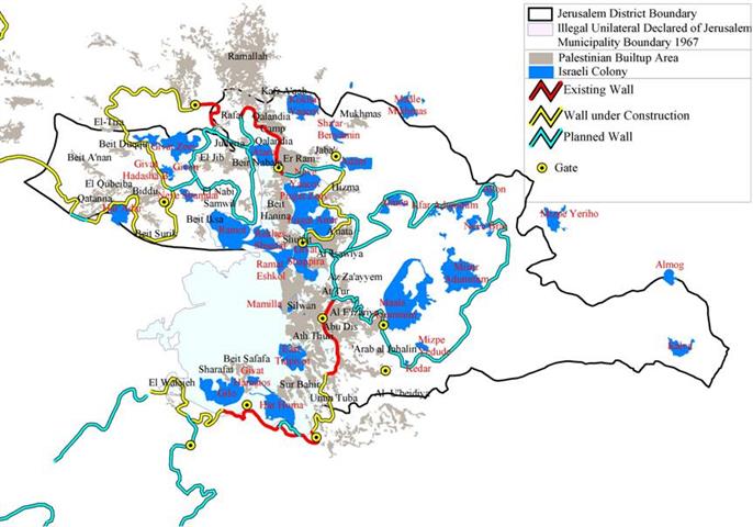
The segregation wall is planned to extend about 190 km around Jerusalem, stretching from the Israeli settlement of Har Adar in the west to encompass the Giv39;at Ze39;ev settlement block (Giv39;at Ze39;ve, Giv39;on and Hiv39;at Hadasha), and then cut between the Palestinian communities of Al Jib, Al Judera, and Beir Nabala, to then stretch eastwards to encompass the Ma39;ale Adumim block of settlements (Ma39;ale Adumim, Mizpe Yedude, Kfar Adummim, Mishor Adumim, Allon, Almon ( Anatot ), Kedar, Neve Brat) and continues to stretch towards the south to encompass the Gosh Etzion Settlement block ( Hadar Bitar, Bitar Ellit, Neve Daniel, Efrat, Rosh Zurim, Gava39;ot, Beit 39;AYIN, Allon Shevut, Eliazar, Kfar Etzion, Migdal Oz). See map 1:
So far, 40 kilometers of the Segregation Wall were completed by mid 2005, another 40 km are still under construction while 110 km are planned sections, of which 40 km are for the Ma39;ale Adumim settlement block envelope. The segregation wall around Jerusalem will isolate 230km2 (4% of the total area of the West Bank, out of which 30 km2 of Palestinian built-up area, 50 km2 of Israeli settlements built-up area while 65% of the isolated area in Jerusalem is an open area. The Jerusalem envelope will segregate 45% of the Jerusalem Governorate area and 13% of the Bethlehem Governorate area. There will be around 230,000 Palestinians in Jerusalem that will be cut from the rest of the West Bank and will be segregated by the Wall.
Palestinian villages enclaved by the Wall in Jerusalem
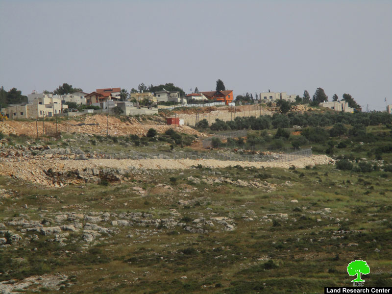
Villages located northwest of Jerusalem city such as Beir Nabala, Al Jib, Al Judera and Beit Hanina Al Tahta will be severely affected by the construction of the Segregation Wall. Israeli Maps published on the Israeli Ministry of Defense web site on February 19, 2005 showed a revised route of the Segregation Wall in the West Bank to take place; changes were mainly in middle and southern areas.
The maps showed that the previously mentioned Palestinian villages will be totally isolated in one big Ghetto and cut off from the nearby Palestinian towns and villages mainly from Ar Ram town, Beit Hanina Al Fouqa(the new and eastern part of Beit Hanina) Qalandyia and northwest Ramallah villages as well as closing the main road between Ar Ram and Beir Nabala. from the nearby Palestinian towns and villages mainly from Ar Ram town, Beit Hanina Al Fouqa(the new and eastern part of Beit Hanina) Qalandyia and northwest Ramallah villages as well as closing the main road between Ar Ram and Beir Nabala
Moreover, the two villages of Al Nabi Samuel and Beit Iksa, located to the southwest of Beir Nabala will be totally separated from Beir Nabala enclave (Beir Nabala and the three Palestinian villages of Al Jib, Al Judera and Beit Hanina Al Tahta), and will be separated also from the cluster of villages north west Jerusalem such as Biddu and the other nearby villages.Palestinian residents living north and northwest of Jerusalem city will have no access to the enclave and will need special permits issued by the Israeli Authority to get into and out of it.
New Israeli activities in Beir Nabala Village
On May 18th, 2005, the Israeli authorities decided to construct four agricultural gates in the Jerusalem Envelope claiming that such gates would free the access of the Palestinian landowners to their lands located behind the wall39;s path. Two of the gates will be constructed east and west of Beit Hanina Al Tahta; the third gate will be constructed southwest of Al Jib village while the fourth gate to be constructed west of Al Judera village.
Palestinian residents particularly depend on agriculture as their main source of income, especially after the eruption of the second Intifada in September 2000, as many people lost their jobs inside the Israeli borders due to the strict Israeli measures of closures and numerous checkpoints that obstructed their ways to work inside Israel and turned to work in agriculture as an alternative source of living. It is worth mentioning that the access of the Palestinian framers to their lands will be very much dependent on the mood of the Israeli soldiers who will be guarding the gates. In similar incidents, such as the cases of northern West Bank villages and towns, Palestinian farmers and land owners are most of the times prevented from accessing their lands; even when allowed, certain conditions are set to control their ins and outs to the lands.
The only link to the Beir Nabala enclave is through an under construction road
Beir Nabala village is located 9 kilometers northwest of Jerusalem city and it houses 6264 inhabitants (the Palestinian Central Bureau of Statistics (PCBC 2005). During the 1970's, the Israeli authorities confiscated vast areas of Palestinian lands from Beir Nabala and the nearby Palestinian villages of Beit Hanina and Ar Ram to construct one of its three largest industrial zones in the West Bank 39;Atarot Industrial Zone39;. 39;.
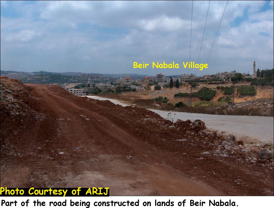
Lately, in July 2005, the IOF handed Beir Nabala Village council a military order, a copy of which was sent to ARIJ and attached to the case, to construct a 2.5km long and 60m wide road on 121 dunums of lands. See Photo 1, Photo 2 & Photo 3


The road, according to Israeli sources, will be constructed for the sake of Palestinian residents, see map 2 and copy of the military order below. , according to Israeli sources, will be constructed for the sake of Palestinian residents, see and below.

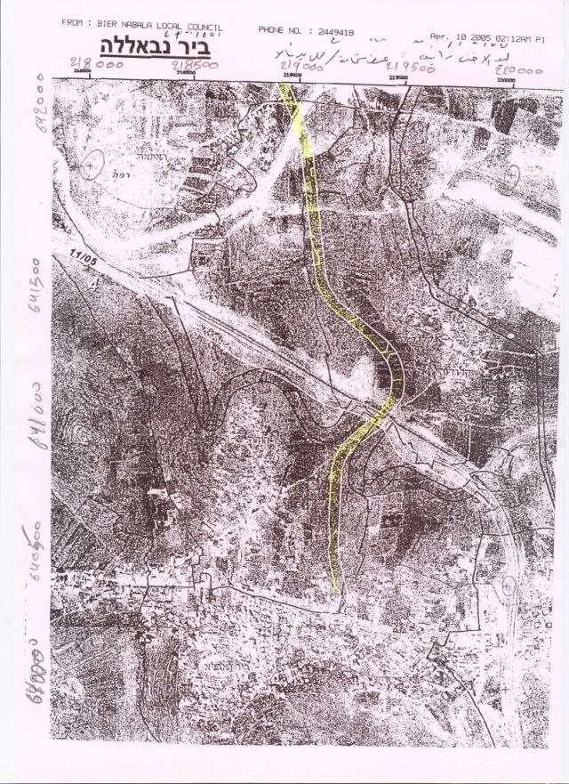
The road, as shown in map one, will connect Beir Nabala enclave (Beir Nabala, Al Jib, Al Judera and Beit Hanina Al Tahta) with Rafat village through Qalandyia. The main entrance to Beir Nabala (and the three enclaved villages) is through Beir Nabala-Ar Ram road which is expected to be closed once the construction of the Segregation Wall is completed. At least 15000 Palestinians (according to PCBS 2005) will lose access to Ar Ram town and will be prohibited from its services.Many obstacles will arise since Palestinian residents will have to travel through long and time consuming alternative routes to reach their destinations. Many obstacles will arise since Palestinian residents will have to travel through long and time consuming alternative routes to reach their destinations.
Conclusion
Although Israel has utilized the pretext of 39;security39; to justify the construction of the Segregation Wall in the West Bank, the Wall39;s path approved to be a land grab tool that Israel used to illegally annex as many Israeli settlements as possible to Israel39;s proper.
Israel, through constructing the wall, has placed many Palestinian communities in shrinking ghettos, isolated from their lands and segregated from neighboring communities, violating international and human rights laws including the right to freedom of movement, access to holy places, to work, to health, to education, and to an adequate standard of living.
•[1] International Covenant on Civil and Political Rights
•[2] supra note 1, para. 129
•[3] International Covenant on Economic, Social, and Cultural Rights and the United Nations Convention on the Rights of the Child.
Read Related cases:
-
Israel’s Segregation Wall Encircles Three Palestinian Villages in Northwest Jerusalem.
-
Illegal Israeli Settlements Expanded Dramatically between 2002 and 2004.
-
The Debate over Israeli Settlements Expansion !!! Lovers Quarrel but Not A Deal Breaker.
Prepared By
The Applied Research Institute – Jerusalem
ARIJ