Location and population
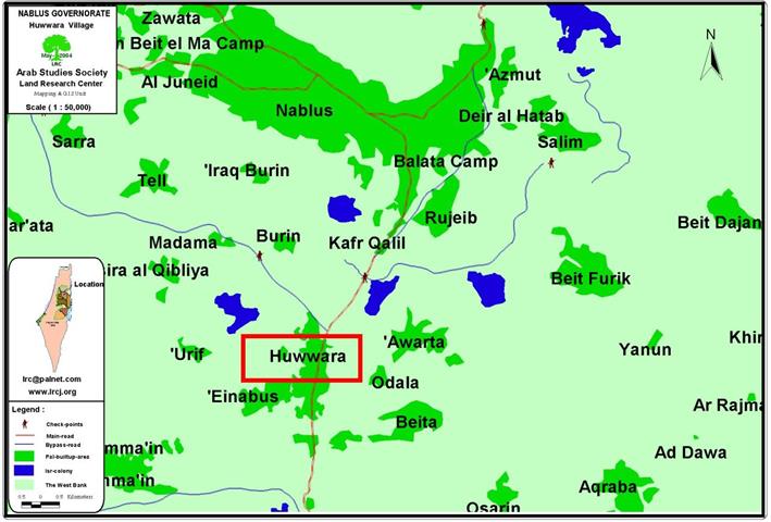
Huwwara town is located 7 km to the south of Nablus city. It houses a population of about 5800 people mostly working in agriculture and commerce. Like most villages and towns in that region, Huwwara is an expanse of land cultivated with olive, almond and fig trees. As regard to commerce, Huwwara is served by its strategic location on the main Nablus-Jerusalem road where more than 230 commercial stores were busy working before the outbreak of the current Intifada. Nowadays, only 40 % of these stores are still working due to the closure of the main road in the face of Palestinian movement. See map of location

The town of Huwwara ( in red quadrangle) crossed by road No. 60 linking between Nablus and Jerusalem
Type of violation
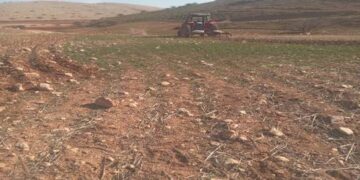
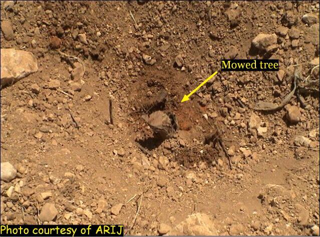
Burning of trees, crops and devastation of agricultural land as well as closing all entrances leading to Huwwara town.
Date of violation
- On 3.5.2004, a group of Israeli settlers from Yetzhar burned a large number of trees and crops
- On 16.5.2004, the Israeli soldiers devastated agricultural land and closed all roads leading to Huwwara town.
Reasons behind violation
- According to Huwwara council leader and residents, the reason behind the burnings of trees is to seize and annex more lands at favor of expanding Yizhar settlement.
- The closure of roads and entrances aimed at further strangulating and encircling of Huwwara town in addition to preventing Palestinians from traveling on the main road passing through the town or from using other detours to reach their destinations.
Perpetrator
The burning of trees was carried out at the hands of Israeli settlers from Yizhar, while the devastation of land and closure of roads were carried out at the hands of the Israeli soldiers. See photo 1

Huwwara- Nablus: Devastation of agricultural land and green houses, Photo courtesy of LRC.
Yizhar settlement
In 1984, the Israeli government endorsed the establishment of Yizhar settlement over lands confiscated from the Palestinian neighboring villages of Burin, Orif, Asirah Al Qibliya, Madama and Huwwara. At the beginning, about 65 settlers lived in it. This number increased to 165 in 1992 and reached to 291 in 1998. Lately, an additional 400 housing units were added to the settlement in compliance with '1/68' planning scheme. See photo 2

Huwwara- Nablus: Devastation of agricultural land and roads, Photo courtesy of LRC
Losses inflicted by burning of fields
The table below shows the losses by name of owner, area in dunums and trees uprooted:
|
No. |
Name of owner |
Area in Dunum |
No. of burned olive trees |
|
1 |
As'ad Mas'ud Khamous |
10 |
80 |
|
2 |
Mahmud Mas'ud Khamous |
10 |
80 |
|
3 |
Tal'at Faiz Odeh |
5 |
Cultivated with cereals |
|
4 |
Ahamd Hasan Dumeidi |
5 |
50 |
|
5 |
Mustafa Mohammed Khamous |
5 |
50 |
|
6 |
Ahmad Mustafa Khuseir |
7 |
50 |
|
Total |
42 |
310 |
|
Farmers managed to estimate the losses of their burned fields while others were unable to do so due to the location of their fields close to the settlement. Huwwara municipality officials estimated the area of the burned fields at 200 dunums, in which, more than 1000 olive trees and 200 almond trees were damaged. See Photo 3 & Photo 4


Huwwara- Nablus: Closure of detour roads around the town, Photos courtesy of LRC
Losses inflicted by bulldozing of land
The table below shows the losses by name of owner, area in dunums and trees uprooted:
|
No. |
Name of owner |
Area in Dunum |
No. of uprooted olive trees |
|
1 |
Ahmad Abdul Aziz Odeh |
1 |
8 |
|
2 |
Bassam Hasan Odeh |
1 |
6 |
|
3 |
Sharif Khader Odeh |
0.5 |
5 |
|
4 |
Amjad Atef Mahmud Adik |
0.5 |
5 |
|
Total |
3 |
24 |
|
Previous violations
1. The deprivation of Huwwara farmers from picking their olive harvest in about 500 dunums of land for the fourth consecutive year by Yizhar settlers.
2. The burning of Huwwara mosque by colonist in October, 2000.
3. The gradual confiscation of more than 1000 dunums from lands of Huwwara for the expansion of Yizhar settlement.
4. The uprooting of at least 2000 olive tree during the past 15 years.
5. Setting up of two permanent military checkpoints at the southern and northern entrances of the town, on the main road connecting Nablus city with Jerusalem. These two checkpoints were erected immediately after the outbreak of the current Intifada in year 2000. Ever since, the town has been subjected to a total closure and were further exacerbated by the bulldozing and closing of all minor roads and exits around the town; thus bringing the percentage of unemployment to an unprecedented level and causing serious effects to the educational, health, economic and social situations in the town. See Photo 5
Huwwara- Nablus: Bulldozing of agricultural lands and trees and closure of detour roads, Photos courtesy of LRC.
Prepared by
The Land Research Center
LRC


