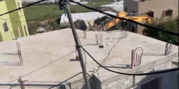
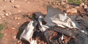
On the early morning of December 1, 2011, the Israeli bulldozers and under the protection of the Israeli Army Forces stormed the western part of Husan village west of Bethlehem city and demolished without prior notifications three structures owned by local residents in the village in addition to seizing more than 4 tons of iron. ARIJ field team paid a visit to “Al-Mashahed” targeted area west of Husan village and interviewed owners of the targeted structures.
The first demolished structure is a nursery owned by the local resident Mohammad Bajes Shoushe where it was built in last year on a total land area of 50 m2. See the pictures below:
The second demolished structure is a car-wash station built in the year 2006 and owned by local resident Firas Sabri Shoushe. The IOA seized a container full of lubricants from the site after demolishing the station. Mr. Shoushe indicated that the total losses are more than 100 thousand NIS. See the pictures below:
The third demolished structure is a car-parts shop owned by the local resident Hasan Mohammad ‘Odeh Hamamreh; Israeli bulldozers demolished two barrackses used as stores in addition to a retaining wall and an iron gate. Mr. Hamamreh indicated that the Israeli occupation Army seized instruments and an electric motor where the estimated losses exceeded 70 thousand NIS. See the pictures below:
Moreover, and before leaving the area the Israeli occupation Army, and without a prior notification or even justification, confiscated more than 4 tons of construction iron, its cost exceeds 10 thousand NIS and is owned by the local resident Fouad Hasan Shoushe. See the pictures below:
Map :The Location of Demolished structures in Hussan village west of Bethlehem
Husan Village: Location & Population
Husan, a Palestinian village in Bethlehem Governorate, located 6.5km west of Bethlehem City. The village is bordered by Battir village to the north, Nahhalin village to the south, Al Khader town to the east, and the 1949 Armistice Line (the Green Line), Wadi Fukin village as well as the illegal Israeli settlements of Betar ‘Illit and Hadar Bitar to the west. The total population of Husan village is 7172 residents (PCBS 2010).
The Geopolitical Divisions of Husan Village Lands
According to the Oslo II Interim agreement of 1995, Husan village lands, as well as the rest of the Palestinian Territory were divided into areas A, B and C. In Area A, the Palestinian National Authority has complete autonomy over administrative and security issues, where in area B, Palestinians have full control over the civil administration and Israel continues to have overriding responsibility for security, while in Area C, Israel has full control over the security and administrative issues. Table 1 clarifies the classification of lands of Husan village:
|
Table 1: Classification of Husan Lands According to Oslo II Interim Agreement of 1995
|
|
Land Classification
|
Area-Dunums
|
%from the total Town lands
|
|
Area A
|
0
|
0
|
|
Area B
|
524
|
7
|
|
Area C
|
6,771
|
93
|
|
Total
|
7,295
|
100
|
|
Source: The Geo-informatics Department – ARIJ 2011
|
Previous Israeli Colonial Activities in Husan Village
Husan village is bordered by the Israeli settlement of Betar ‘Illit, from the south, and the Green Line (1949 Armistice Line) from the west. After the Israeli occupation of the West Bank and Gaza Strip in 1967, the successive Israeli governments pursued an aggressive policy of land confiscation for the construction of Israeli settlements, military bases, and bypass roads in order to link the settlements with each other and maintain a presence in the West Bank. Husan, like many other Palestinian villages and towns in the Occupied Territory, lost a considerable area of its lands, 3435 dunums (47% of the total village area – 7259 dunums) for the construction of the Israeli settlement of Bitar ‘Illit in 1985. Husan village also lost a part of its territory, equivalent to 4 dunums, for the construction of the neighboring Hadar Betar settlement. See Table 2 below:
|
Table 2: Illegal Israeli Settlements Built on Husan Village Lands
|
|
Settlement Name
|
Establishment
Date
|
Total area of settlement
(Dunums)
|
Total area confiscated from Husan Village lands
|
Population
(2009)
|
|
Hadar Bitar
|
1978
|
58
|
4
|
30
|
|
Bitar ‘Illit
|
1985
|
4686
|
3,430
|
36,400
|
|
Total
|
*****
|
4744
|
3434
|
36,430
|
|
The Geo-informatics Department – ARIJ 2011
|
The Segregation Wall in Husan Village
According to the updated Segregation Wall plan published on the web page of the Israeli Ministry of Defense on April 30, 2007; Husan and the rest of the village west of Bethlehem city (Al Walajeh, Nahhalin, Wadi Fukin, Al- Jab’a, Khallet ‘Afana, Khallet Al Balluta, and Beit Sakariya) will be set in an enclave and in isolation from the main cities and centers of life in Bethlehem governorate (Bethlehem, Beit Jala, and Beit Sahour).
To Conclude
The Israeli systematic house destruction campaign carried out by the Israeli Army in all over the oPt flagrantly violates the International law rules and conventions and United Nations resolutions.
-
Moreover Art. 23 of the Hague Convention of 1907 also provides: In addition to the prohibitions provided by special Conventions, it is especially forbidden to destroy or seize the enemy’s property, unless such destruction or seizure be imperatively demanded by the necessities of war.
-
Also under the Universal Declaration of Human Rights Adopted and proclaimed by General Assembly resolution 217 A (III) of, December 10, 1948, Article 17 reads: ‘No one shall be arbitrarily deprived of his property.’ Which means it bans Israel from destroying or confiscating the property of the Palestinians at any case.
-
In the year 2004 the United Nations Security Council called on Israel to stop demolition of Palestinian homes under Resolution No. 1544-(2004), the resolution states: ‘The Security Council called on Israel to respect its obligations under international humanitarian law, particularly the obligation not to undertake home demolitions contrary to that law’.


