Introduction
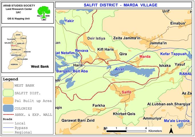
The settlement of Ariel, located at the eastern hills of the Governorate of Salfeet on Palestinian lands belonging to Palestinians from the villages of Marda, Hares, Bruqin, Iskaka and Salfeet, is considered to be a source of continuous and real challenge to the Palestinian existence in that area. The settlement started as a small one that was soon developed and expanded to become one of the largest Israeli settlements in the area. It sits atop hundreds of dunums of fertile lands that has high yield of olives and olive oil and was the main source of income for its Palestinian owners. The latest population census indicated a population of more than 17,000 settlers living in the colony most of whom are extremists calling for the forced eviction and transfer of Palestinian Arabs.
Map 1: location of Marda village and Ariel colony, Salfit governorate))
Flooding caused by Wall
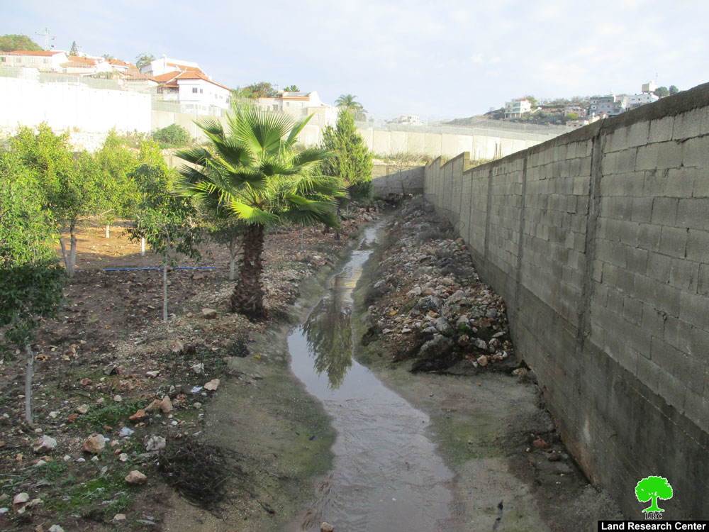
Israeli occupation forces established the Segregation Wall around the settlement in 2004 which caused the confiscation and separation of hundreds of fertile lands surrounding it. In addition, these forces placed large water tunnels beneath the route of the Wall which is placed at the edge of a mountain under which a number of Palestinian villages and lands are present. This situation has led to a number of flooding incidents the latest of which took place at the beginning of this month after large quantities of rain befell on the vicinity of the settlement (124 mm in 14 hours) causing flooding through these tunnels and, subsequently, the spoilage of a large number of dunums. See Photo 1 & Photo 2


(Photo 1 & Photo 2: Rain mixed with sewage floods sweeping over agricultural land
in Marda village, Salfit district), Photo courtesy of Salfit municipality.
It is worth noting here that the occupation authorities took advantage of the situation and pumped the colony's sewage into the tunnels allowing it, in the process, to mix with the rain water headed towards Palestinian lands and houses in the nearby Murda village. This action has led to the submerging of houses as far as 200 aerial meters away from the Wall. One of the affected houses is that of Mr. Nabeel Hasan Sa'id whose house (in which four families live) was submerged with more than 6 cm of the rain/sewage mix. Moreover, the flooding led to the destruction and spoilage of fertile lands close to the Wall some of which were planted with vegetables. Examples include the lands of Mr. Nisfat Al Khufash whose 2-dunum land was polluted and crops damaged.
In addition to the above-mentioned effects, the polluted water is a major source of illnesses in the village which must be dealt with medically before the diseases become epidemics that require large sums of money to combat. Such monies are simply not present in the budget of the village or other entities working in the region.
Drinking water contaminated
On the other hand, the rain/sewage mix that poured from the settlement of Ariel to the west of the city of Salfit went into Al Matwi Valley which is filled with water springs. The flooding led to the increase of the water level in the Valley and to the pouring of water towards Al Matwi Well located only 30 meters away from the pathway of the liquid sewage stemming from the settlement of Ariel. The rain/sewage mix blended with the water of the well which has a 100 m3 capacity and pumping rate of 20 m3 per hour. The new blend was then transported via water networks to houses in the city of Salfit, Khirbat Qais and the village of Farkha located south of Salfit city. The quantity of the pumped blend reached 65 m3 which forced the Salfit Municipality and the Ministry of Health to stop the pumping process and start sanitizing the entire water network, a process which caused it to deplete its already-strapped financial resources. Moreover, the Municipality started to plan for the construction of a wall around Al Matwi Well to safeguard it against any future sewage discharge. Again, the Municipality does not have the necessary funds to build such a wall which will come at the cost of other programs offered by it. See Photo 3

(Photo 3: another flooded area in Marda village,
Salfit district),
Photo courtesy of Salfit municipality
The above-mentioned Al Matwi Well meets 30% of the drinking needs of the city of Salfit, Khirbat Qais and the village of Farkha, while the remaining 70% is provided through the Israeli Water Company (Mecharott). As a result of this pollution, Palestinians in these communities will find themselves obliged to depend more on the Israeli Water Carrier which usually means additional financial obligations towards it. Another source of contamination to the Matwi Valley is the pollutants stemming from the Israeli factories located inside the nearby colony of Burqan.
Finally, the affected Palestinians have submitted a petition last year to the so-called Civil Administration to stop the recurrent violations in association with village councils and BTselem. They received promises from the Civil Administration to solve the problem, yet to no avail as the recent events indicate the purposeful intention of Israeli authorities to cause harm to Palestinians.
Prepared by
The Land Research Center
LRC


