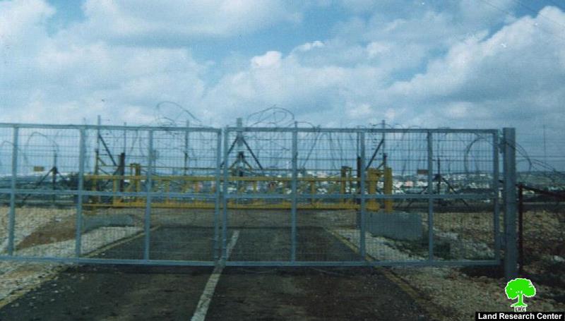
During the latest olive harvesting season, and as part of the on going war against the Palestinian people and their livelihood sources, the Israeli occupation forces took a number of measures restricting farmers' movement and access to their olive fields separated behind the Segregation Wall in Masha village, Salfit governorate.
The measures included the following:
1. The closure of the Wall agricultural gates situated to the north and west of the village during the whole period of the olive picking season depriving farmers and land owners from reaching their fields and collecting their harvest;
(Photos 1 & 2: the closed north and wet gates )
2. Referring farmers and land owners to Azzun Atma's Wall agricultural gate located 8 km to the north west of Masha, creating more obstacles and hindrances on the way of poor villagers and farmers trying to access their lands.
3. Only 20% of Masha farmers have been 'granted' proper passing permits issued by the Israeli military allowing them to access their lands behind the Wall. As requirements to get such permits, farmers and land owners are asked to be security cleared and to bring all land ownership documents, including taboos. Even, their wives, and children above 16 years old are asked to apply and acquire passing permits to get into their lands through these ill-fated agricultural gates. This means they have to pay more fees to the Israeli military to get the required passing permits. In many occasions, farmers' children applying for such permits are summoned to the offices of the Israeli intelligence in the so-called ' Israeli civil administration' and bargained for collaboration in exchange for these permits. This blackmailing method is widely used in all the ' Civil administration offices' through out the West Bank, involving all sectors of Palestinian youth manpower intending to enter Israel. Even, in some cases, depending on the whims of individual soldiers, those who obtain passing permits are denied access.
Location and population
The village of Masha is located in the governorate of Salfit. It is situated about 20 km to the west of the city of Salfit, 35 km to the west of Nablus and 6 km to the east of the green line. Before the war of 1967, it had the population of 1000 inhabitants. This number decreased to 600 after the war due to exodus. According to the 2002 census conduced by Palestinian Central Bureau of Statistics, the village population was 2000.
(Map 1: location of Masha-Salfit and the Wall agricultural gates)
The village of Masha is considered the mother village of Kufr Qasem town which is located in the triangle region inside the 1949 Green Line. Before 1948, the land of Masha expanded westward until Al Oja river where is located the fertile land. Therefore, quite a lot of Masha people moved to settle in the town of Kufr Qasem to take care of their land. In 1956, the Zionist gangs committed a massacre against the people of Kufr Qasem in which more than 50 men were killed, forcing survivals to flee away.
Following the war of 1948, the two villages were split apart: 70 % of Masha land was annexed into Israel, including the town of Kufr Qasem; 30 % of the land remained in West Bank proper, including the village of Masha.
It is worth mentioning that before 1967, about 80 % of the people of Masha depended on agriculture and animal rearing as main income, while the remaining 20 percent worked as civil servants.
From 1967 until 1996 a big number of them worked as laborers in Israel. From 1996 until 2000, they worked as merchants in Masha regional market which employed not less than 5000 workers from Masha and surrounding villages and towns. The market was active until the year 2000 when the Israeli army destroyed it following the outbreak of the second Intifada. As a result, about 75 % of Masha work force became jobless.
Village area
The village area is estimated at 7870 dunum, of which 1015 dunums are built up area and another 300 dunum cultivated with crops and irrigated vegs. There are another 3500 dunums planted with olive trees and 900 dunum with cereals. The remaining 2155 dunums are used as range land.
In 1978, the village came under an extensive colonial onslaught by Ghush Amunim during which more than 1000 dunum of the village land were confiscated for Jewish construction. Now, there are three settlements built on Masha land:
|
Settlement name |
Date of establishment |
Population in 2004 |
Municipal area dunum |
Built up area dunum |
|
Etz Efrayim |
1985 |
627 |
458 |
184 |
|
Elkana |
1977 |
3050 |
1198 |
758 |
|
Sha'are Tikva |
1982 |
3692 |
1045 |
915 |
|
Total |
7369 |
2701 |
1857 |
|

Photo 3: the settlement of Sha'are Tikva surrounded with the Wall
Economic impacts of the Wall on Masha
1. The construction of the Wall has led to the expropriation of large areas of agricultural land, mostly cultivated with olive, citrus and fruit trees as well as vegs. Apart from this, between 15 to 20 dunum were used as green houses for irrigated vegetation before seizure.

Photo 4: The village of Masha, to the left , separated from its land, to the right, by the Wall)
2. At least 1000 olive trees were uprooted, destroyed or separated by the construction of the wall.
3. The only artisan water well in the village (Ash Shila Well) was also taken.

(Photo 5: The artisan well of Ash Shila separated behind the wall)
4. The Wall construction led to the demolition of 7 barracks for animal production.
5. The commercial market of Masha village was destroyed by army bulldozers during the Wall construction process.
6. The Wall has seriously affected the local people's access to education, health, services�etc.
Prepared by
The Land Research Center
LRC


