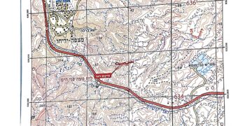
The Israeli occupation Army have continued their policy of plundering Palestinian lands, as their bulldozers leveled wide areas of agricultural land in the village of Raba, southeast of Jenin Governorate, in preparation for constructing a military road 12 km long. The road is planned to extend from the north of Khirbet Ibziq in Tubas Governorate to the area of Jabal al-Salameh, located on the lands of Raba village.
According to local sources, the route of the new road is not limited to the lands that had previously been designated for seizure, but also extends to include vast agricultural areas located east of the separation wall. This will effectively deny residents’ access to more than 2,300 Dunams of their farmland.
This measure falls within a systematic escalation of settlement and confiscation policies. Landowners face these violations with continuous attempts to resist, while the occupation authority resort to firing tear gas canisters to suppress residents and forcibly drive them away from their lands. Estimates indicate that the area is at risk of the confiscation of tens of thousands of additional Dunams for the benefit of Israeli roads and military camps.
Earlier, the occupation had issued notices for the seizure of lands in the southern and southeastern parts of the village under the pretext of building a military road and establishing a military base in the Jabal al-Salameh area. The total area of Raba village amounts to about 27,000 Dunams, with nearly 5,000 inhabitants. Since 2003, the village has suffered the confiscation of wide parts of its lands for the construction of the Segregation wall.
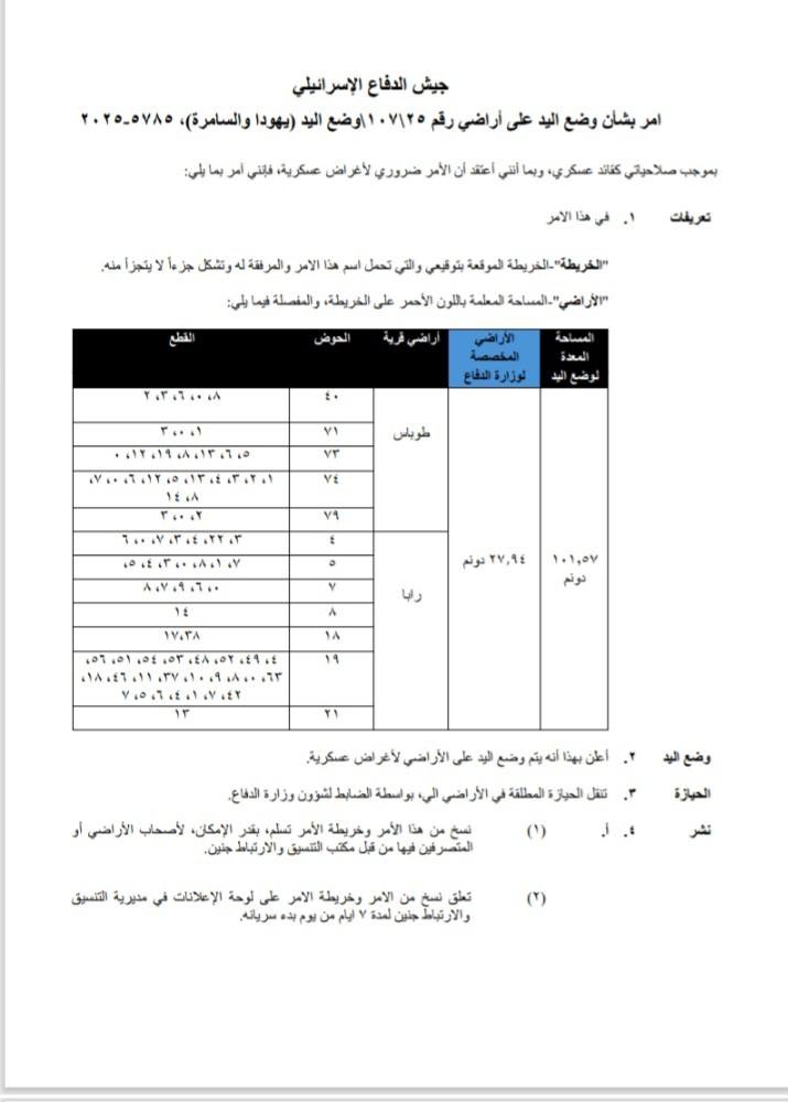
The Military Order
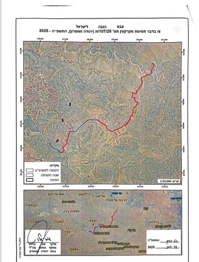
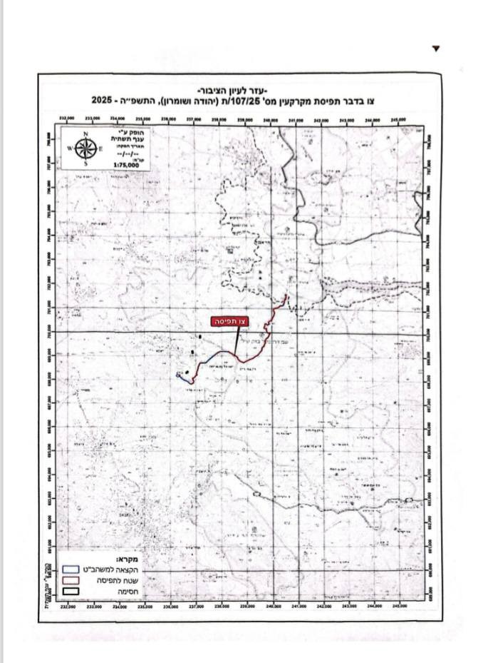
It is noteworthy that the ongoing land leveling is being carried out in implementation of a military order issued by the so-called commander of the Israeli occupation army in the occupied West Bank, under the title: “Order to Seize Lands No. 25/107/ Seizure of Lands Judea and Samaria.” The order stipulates the confiscation of 102 Dunams of privately owned land registered with Jordanian land deeds (Tabu) and finalized during the Jordanian era. According to this order, the authority to dispose of these lands is transferred to the commander of the occupation army under the pretext of “security purposes.” The military order also specified that around 28 Dunams of this land would be placed under the direct authority of the Israeli “Ministry of Defense,” with the army directly responsible, while the remaining areas may fall under the administration of the so-called “Civil Administration.”
 |
 |
 |
 |
The Military order
Noteworthy Aspects of the Military Order
What stands out in the issued military order is that it stipulates the seizure and control of land without revoking ownership, under the pretext of military use. According to international law, a military commander in occupied territories may temporarily seize specific plots of land if required by military necessity, if the purpose is to protect the population under occupation or to meet urgent and temporary wartime needs. However, in this case, it is clear that the occupation army is exploiting this authority in a manipulative way: the lands are seized under the pretext of “security needs,” while the actual goal is to pave roads that serve Israeli settlements or settler outposts established in the area.
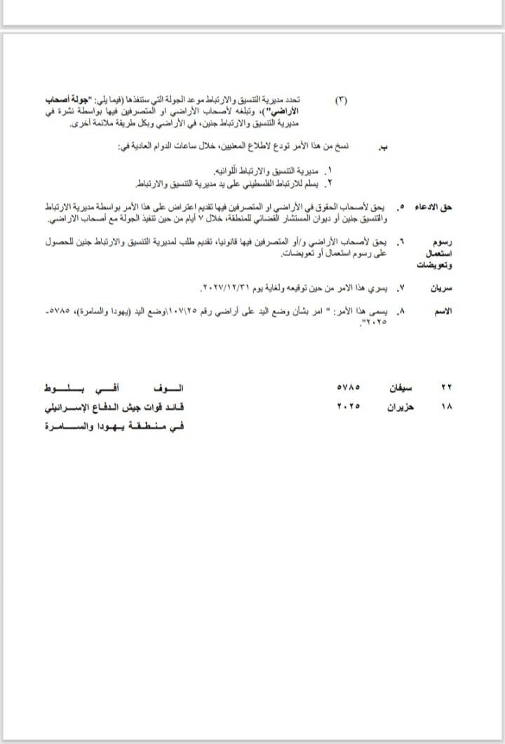
The military order sets a temporary period for land seizure until 31/12/2027, but past experience with similar orders in the West Bank shows that they are often automatically renewed, entrenching a permanent colonial reality.
Establishment of a New Outpost and Destruction of a Farm Road in Jabal al-Salameh
A group of settlers established a new outpost in the Jabal al-Salameh area, consisting of a tent and several makeshift structures near the settler military road carved out by the occupation in the area. The outpost was erected on lands classified as Jordanian treasury lands, with an estimated area of one Dunam. Settlers have been working to prevent Palestinian farmers from accessing or benefiting from their lands, in a move designed to impose full control over the area.
In the same context, during the construction of the settler military road, occupation authorities bulldozed part of an existing farm road in the area. This road has become difficult for farmers to use due to the presence of the outpost, which is located just 15 meters away, and because it runs adjacent to the settler military road. It is worth noting that most of the route of the farm road passes through privately owned Palestinian lands, documented with Jordanian land deeds (Tabu), though not fully processed through the formal land settlement system.
Land Confiscation in the West Bank
Since the beginning of 2025, Israeli occupation authorities have confiscated tens of thousands of Dunams of Palestinian land across the West Bank. The seizures have been distributed across multiple areas, including the northern Jordan Valley, Ramallah, Hebron, Jerusalem, Bethlehem, Salfit, Tubas, Nablus, and Jericho. These confiscations targeted agricultural, grazing, and residential lands, most of which are owned by Palestinian Bedouin families and farmers. Many of these properties are documented with official ownership deeds dating back to the Ottoman era or Jordanian records, in blatant violation of the principle of secure tenure recognized under law.
Military Orders as a Tool of Control
The occupation employs multiple methods to confiscate land, including military orders issued under the pretext of “security,” declaring land as “state land,” classifying it as a “nature reserve,” or designating it as a “military training zone.” Despite the different labels, the goal is the same: to empty the land of its Palestinian inhabitants and later reallocate it for settlement and colonial expansion projects. The occupation also resorts to the “Absentees’ Property Law” to register lands whose owners were forcibly displaced, as well as the so-called “land settlement” process, which is being accelerated through the “Civil Administration” to entrench a new settlement reality in Area C, turning thousands of Dunams into official property of the occupying state or settlement councils.
Violations of International Law
These policies constitute a blatant violation of international humanitarian law, particularly Article 49 of the Fourth Geneva Convention, which prohibits forced displacement and the transfer of populations within occupied territories, and Article 46 of the 1907 Hague Regulations, which stipulates the protection of private property. Moreover, the International Court of Justice, in its advisory opinion issued in July 2024, affirmed that the West Bank, including East Jerusalem, is occupied territory, and that any measures aimed at altering its demographic or geographic character are null and void.
The conduct of the occupation reflects a systematic exploitation of the vacuum in international justice through a network of military orders and laws since 1967. These present themselves as “legal” instruments but are in fact used to legitimize expropriation and reclassify confiscated lands as “public” or “abandoned” property, before transferring them to settlement councils under the pretext of “security” or the “public good.” The result is a policy of geographic cleansing that seeks to eradicate the Palestinian rural way of life and fragment the West Bank into isolated cantons subjected to an apartheid system combining military, administrative, and settler colonial control. These policies not only seize land but also strike at the heart of Palestinian social, cultural, and economic structures, driving communities into poverty, forced displacement, and social disintegration.
Raba Village
Raba is a Palestinian village with a population of about 5,000 residents, located on the summit of Mount al-Salameh (or Ibziq), southeast of Jenin Governorate, about 20 km from Jenin city, situated between the villages of Jalqamus and Zababdeh and overlooking the Jordan Valley. The village covers an estimated area of 27,000 Dunams, including around 12,000 Dunams of forested land. Under the Oslo Accords signed between the occupying government of Israel and the Palestine Liberation Organization in 1993, the village’s lands were divided between Area A (full Palestinian control) and Area B (Palestinian control over civil affairs, while security authority remains under Israeli occupation).
Prepared by:
The Applied Research Institute – Jerusalem