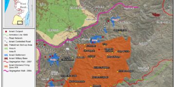
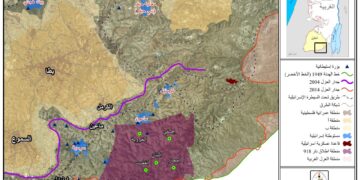
• About The Project
  • Palestine in Century
  • Selected Maps
  • Glossary
  • About ARIJ
  • About LRC
  • By Year
    • Case Studies By Year
    • Daily Report By Year
Friday, October 10, 2025
POICA
No Result
View All Result
  • Home
  • Settlements
    • New Israeli Settlements
    • Settlement Expansion
  • Israeli Violations
    • Agriculture
    • Confiscation
    • Demolition
    • Environment
    • Eviction of Palestinians
    • Settlers Attacks
  • Bypass Roads
  • Israeli Plans
  • Segregation
    • Checkpoints
    • Closure
    • Separation Plans
  • Military Orders
  • Reports
    • Daily Report
    • Monthly Report
    • Quarterly Report
No Result
View All Result
POICA
No Result
View All Result

The Geopolitical Status of Jabal al Mukabbir & As Sawahira al Gharbiya Town

March 14, 2023
in Israeli Violations
The Geopolitical Status of Jabal al Mukabbir & As Sawahira al Gharbiya Town


Location

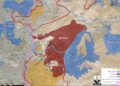
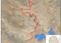
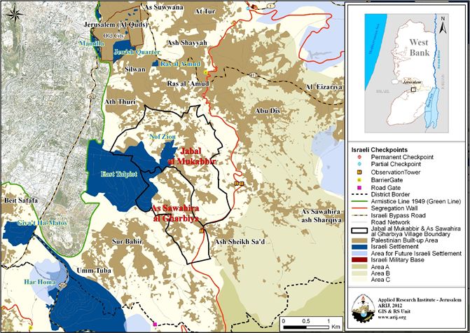
Jabal al Mukabbir & As Sawahira al Gharbiya is a Palestinian town in Jerusalem Governorate, to the south of the city. It is bordered by Abu Dis and As Sawahira ash Sharqiya to the east, Silwan and Jerusalem city to the north, the settlements of Telpiot and Nof Zion to the west, and Ash Sheikh Sa’d and Sur Bahir & Um Tuba to the south (ARIJ, 2022). The town of Jabal al Mukabbir & As Sawahira al Gharbiya is home to 26,140 Palestinians (JIPR)[1] and the majority are Jerusalem Identity card holders.

The Geopolitical Status of Jabal al Mukabbir & As Sawahira al Gharbiya Town

Jabal al Mukabbir & As Sawahira al Gharbiya town covers an area of 5,021 dunums and is located under the control of Jerusalem Israeli Municipality, which was illegally and unilaterally redrawn in 1967 after the Israeli Occupation of the West Bank including East Jerusalem, in addition to Gaza Strip and other Arab lands. Jerusalem Governorate was divided into two main regions: J1 area is located inside the borders and under the control of Jerusalem Municipality, and includes many Palestinian communities from the Old Town and Jerusalem City (Beit Al Maqdis), in addition to Jabal al Mukabbir & As Sawahira al Gharbiya town which is located in J1’s southern area. The other region is J2, which is located outside the borders and control of Jerusalem Municipality. The eastern and western parts are under the control of Palestinian Authority’s where the central part of the Governorate remains under Israeli Occupation control

Full Report, click here


[1] Jerusalem Institute for Policy Research

shnaton_C0522.pdf (jerusaleminstitute.org.il)


Prepared by:  
The Applied Research Institute – Jerusalem

Recommended For You

تصعيد إسرائيلي جديد: الاحتلال يهدم مبنى في بيت لحم ويواصل سياسة التطهير المكاني

by arij
August 12, 2025
0
تصعيد إسرائيلي جديد: الاحتلال يهدم مبنى في بيت لحم ويواصل سياسة التطهير المكاني

في استمرار لسياسة الهدم والتضييق التي تنتهجها سلطات الاحتلال الإسرائيلي بحق الفلسطينيين وممتلكاتهم، نفذت آليات وجرافات تابعة لقوات الاحتلال، صباح اليوم الأربعاء 6 آب 2025، عملية هدم واسعة...

Read moreDetails

Villages and Communities of Masafer Yatta: A Model of the Forced Displacement of Palestinian Communities in Area “C”

by arij
August 2, 2025
0
Villages and Communities of Masafer Yatta: A Model of the Forced Displacement of Palestinian Communities in Area “C”

Introduction: Since its occupation of the West Bank in 1967, Israel has pursued a long-term policy aimed at minimizing Palestinian presence in Area “C”, which constitutes approximately 61%...

Read moreDetails

قرى وتجمعات مسافر يطا: نموذج تهجير التجمعات الفلسطينية في المنطقة “ج” سياسة ممنهجة لاقتلاع الوجود الفلسطيني

by arij
August 6, 2025
0
قرى وتجمعات مسافر يطا: نموذج تهجير التجمعات الفلسطينية في المنطقة “ج” سياسة ممنهجة لاقتلاع الوجود الفلسطيني

مقدمة: منذ احتلالها للضفة الغربية عام 1967، تنتهج إسرائيل سياسة طويلة الأمد تهدف إلى تقليص الوجود الفلسطيني في المناطق المصنفة "ج"، التي تشكل ما نسبته 61% من الضفة...

Read moreDetails

قرية النعمان ضحية خطوة تهويديه أخرى: بلدية القدس الإسرائيلية تستهدف ديمغرافيا الوجود الفلسطيني

by arij
August 6, 2025
0

في خطوة تصعيدية جديدة ضمن سلسلة من الإجراءات التهويدية، أخطرت سلطات الاحتلال الإسرائيلي بتاريخ الثلاثين من تموز 2025 كافة منازل قرية النعمان الواقعة شمال شرق بيت لحم وجنوب...

Read moreDetails

Nu’man Village: A Victim of another Judaization Campaign

by arij
August 2, 2025
0
Nu’man Village: A Victim of another Judaization Campaign

In a new escalation within a systematic Judaization campaign, Israeli municipality of Jerusalem issued mass demolition orders on July 30, 2025, targeting all homes in the village of...

Read moreDetails
Next Post

ARIJ Daily Report – Fri 20th 05 2022

LATEST NEWS

محافظة أريحا على خريطة المصادرة الإسرائيلية- إسرائيل تسعى للاستحواذ على أكثر من 7000 دونم في منطقة النبي موسى

محافظة أريحا على خريطة المصادرة الإسرائيلية- إسرائيل تسعى للاستحواذ على أكثر من 7000 دونم في منطقة النبي موسى

by arij
October 9, 2025
0

........................................................

ما يزيد عن 1900 دونما من الأراضي الفلسطينية في بيت لحم مهددة بالعزل لصالح مستوطنة افراتا

ما يزيد عن 1900 دونما من الأراضي الفلسطينية في بيت لحم مهددة بالعزل لصالح مستوطنة افراتا

by arij
October 8, 2025
0

........................................................

Annexation of the Jordan Valley: Implications for the Two-State Solution and Regional Stability

Annexation of the Jordan Valley: Implications for the Two-State Solution and Regional Stability

by arij
September 29, 2025
0

........................................................

Isolation of Three Villages Northwest of Jerusalem: Silent Annexation Creeps toward the Capital

عزل ثلاث قرى فلسطينية شمال غرب مدينة القدس: الضم الاسرائيلي الصامت يزحف نحو محيط العاصمة

by arij
September 24, 2025
0

........................................................

flag_yellow_lowEU-PfP-Logo

This website and its content were initiated in 1993 by the Applied Research Institute – Jerusalem (ARIJ) and the Land Research Center (LRC) with the support from the European Union up until 2023. Since then, the Applied Research Institute – Jerusalem (ARIJ) has taken over the continued development and maintenance of the website. The views expressed remain solely those of ARIJ) and do not necessarily reflect those of the European Union.

© 2025 Copyright ARIJ . All Rights reserved. .

No Result
View All Result
  • Home
  • Settlements
    • New Israeli Settlements
    • Settlement Expansion
  • Israeli Violations
    • Agriculture
    • Confiscation
    • Demolition
    • Environment
    • Eviction of Palestinians
    • Settlers Attacks
  • Bypass Roads
  • Israeli Plans
  • Segregation
    • Checkpoints
    • Closure
    • Separation Plans
  • Military Orders
  • Reports
    • Daily Report
    • Monthly Report
    • Quarterly Report

© 2025 Copyright ARIJ . All Rights reserved. .