• About The Project
  • Palestine in Century
  • Selected Maps
  • Glossary
  • About ARIJ
  • About LRC
  • By Year
    • Case Studies By Year
    • Daily Report By Year
Wednesday, September 10, 2025
POICA
No Result
View All Result
  • Home
  • Settlements
    • New Israeli Settlements
    • Settlement Expansion
  • Israeli Violations
    • Agriculture
    • Confiscation
    • Demolition
    • Environment
    • Eviction of Palestinians
    • Settlers Attacks
  • Bypass Roads
  • Israeli Plans
  • Segregation
    • Checkpoints
    • Closure
    • Separation Plans
  • Military Orders
  • Reports
    • Daily Report
    • Monthly Report
    • Quarterly Report
No Result
View All Result
POICA
No Result
View All Result

Military Order Targets 83.5 dunums to Expand At-Tayba crossing West Tulkarm

June 17, 2021
in Military Orders
Military Order Targets 83.5 dunums to Expand At-Tayba crossing West Tulkarm


  • Violation: confiscating 83.5 dunums.
  • Location: Far’un and Irtah villages / Tulkarm governorate.
  • Date: April 18th 2021.
  • Perpetrators: The Israeli Occupation forces.
  • Victims: Farmers at the area.

Description:

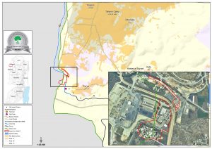
April 18th 2021, West Bank Army Commander issued a new military order entitled (an order of confiscation (03/32/t) extending period of validation 5 and modifying borders 2) , to extend the confiscation period of (65.3 dunums) of Far’un and Irtah village lands west Tulkarm, which was confiscated in the past with similar military orders, in addition to confiscating (18.19 dunums) at the same location, resulting the closure of 83.5 dunums with the aim of expanding At-Tayba military crossing point to the occupied territories of 1948 (Israel).

Photos 1-2:  At-Tayba crossing


Photos 3-5: The military order and the attached map

The targeted lands are:

Village

Natural block

location

Irtah

8455

81

8467

1,2,46

Far’un

8465

1, 3-6, 10 , 9

8466

1, 3


In 2003, the Israeli Occupation issued a confiscation military order to set up a crossing point for Palestinian workers, it also includes the Israeli Liaison Office for Tulkarm area, The Occupation named it “Sha’ar Efraim”  , since then the confiscation period was extended five times. And according to the notice, the confiscation is valid until December 2022.

Within the past few months, the occupation expanded 18 crossings and checkpoints along the Annexation and Expansion Wall, in addition to developing the structures of the crossing area to maintain “Israeli Security” as they claim. Thus, the occupation is devouring more lands for the expansion of the crossings and security zones.

In reality, At-Tayba crossing is a threat imposed on Far’un village, the occupation’s illegal colonies intentionally open waste water towards palestinian agricultural fields causing the spread of harmful insects and diseases. The Occupation authorities – on the pretext of the crossings checkpoints and area-  are also imposing restrictions on land use and access, noting that most lands around At-Tayba crossing are agriculture , and due to the so called Security measures about 35 dunums are inaccessible.


Prepared by
The Land Research Center
LRC


Recommended For You

Nablus Governorate’s Archaeological Sites Face Israeli Expropriation Plans

by arij
September 9, 2025
0
” المواقع الأثرية في محافظة نابلس… ساحة مفتوحة أمام مخططات المصادرة الإسرائيلية “

On 10 August, 2025, the Israeli Civil Administration (ICA), issued a booklet of military orders signed by the head of the so-called ‘Israeli Civil Administration’ in the occupied...

Read moreDetails

” المواقع الأثرية في محافظة نابلس… ساحة مفتوحة أمام مخططات المصادرة الإسرائيلية “

by arij
August 26, 2025
0
” المواقع الأثرية في محافظة نابلس… ساحة مفتوحة أمام مخططات المصادرة الإسرائيلية “

في العاشر من شهر اب من العام 2025, أصدرت الإدارة المدنية الإسرائيلية كراسة أوامر عسكرية موقعة من قبل رئيس ما يسمى "بالإدارة المدنية الإسرائيلية" في الضفة الغربية المحتلة,...

Read moreDetails

“سيطرة من تحت الأرض”, بواقع 108 أمرا عسكريا, سيطرة اسرائيلية على مياه الفلسطينيين في الضفة الغربية المحتلة

by arij
August 12, 2025
0
بواقع 86 أمرا عسكريا – الأوامر العسكرية الإسرائيلية, الأداة الرئيسية للاحتلال الاسرائيلي للسيطرة على المياه الفلسطينية في الضفة الغربية المحتلة

مقدمة، لطالما شكّلت أزمة المياه إحدى القضايا الأكثر صعوبة في الأراضي الفلسطينية المحتلة، إلا أنها في العقود القليلة الماضية اتخذت منحًنا تصاعديًا خطيرًا، حتى بلغت مستويات غير مسبوقة....

Read moreDetails

تهويد صامت بالأمتار: الطريق إلى بني كيديم خطوة نحو الشرعنة الاستيطانية

by arij
July 16, 2025
0
تهويد صامت بالأمتار: الطريق إلى بني كيديم خطوة نحو الشرعنة الاستيطانية

في الثامن عشر من شهر حزيران من العام 2025، تسلّم أهالي بلدتي سعير والشيوخ الواقعتين شمال شرق محافظة الخليل أمراً عسكرياً إسرائيلياً جديداً يقضي بمصادرة 4.8 دونما من...

Read moreDetails

من غير شرعية إلى واقع مفروض, البؤرة الاستيطانية سدي بوعز في رعاية الاحتلال

by arij
July 15, 2025
0

في الثامن من شهر تموز من العام 2025، سلّمت سلطات الاحتلال الإسرائيلي أمرًا عسكريًا جديدًا يقضي بمصادرة أراضٍ فلسطينية وممتلكات خاصة في بلدة الخضر جنوب غرب محافظة بيت...

Read moreDetails
Next Post
إخطار عسكري بمصادرة 83.5 دونماً بهدف توسعة معبر الطيبة غرب مدينة طولكرم

إخطار عسكري بمصادرة 83.5 دونماً بهدف توسعة معبر الطيبة غرب مدينة طولكرم

LATEST NEWS

” المواقع الأثرية في محافظة نابلس… ساحة مفتوحة أمام مخططات المصادرة الإسرائيلية “

Nablus Governorate’s Archaeological Sites Face Israeli Expropriation Plans

by arij
September 9, 2025
0

........................................................

Sebastia: Historical Memory Facing the tempest of Settlements

by arij
September 8, 2025
0

........................................................

سبسطية: ذاكرة التاريخ في مواجهة مقصلة الاستيطان

by arij
September 8, 2025
0

........................................................

Israeli Breach of the Hebron Agreement through the Establishment of a New Settlement in Area (H1)

Israeli Breach of the Hebron Agreement through the Establishment of a New Settlement in Area (H1)

by arij
August 26, 2025
0

........................................................

flag_yellow_lowEU-PfP-Logo

This website has been produced with the assistance of the European Union. The contents of this publication are the sole responsibility of ARIJ & LRC and can in no way be taken to reflect the views of the European Union.

© 2025 Copyright ARIJ . All Rights reserved. .

No Result
View All Result
  • Home
  • Settlements
    • New Israeli Settlements
    • Settlement Expansion
  • Israeli Violations
    • Agriculture
    • Confiscation
    • Demolition
    • Environment
    • Eviction of Palestinians
    • Settlers Attacks
  • Bypass Roads
  • Israeli Plans
  • Segregation
    • Checkpoints
    • Closure
    • Separation Plans
  • Military Orders
  • Reports
    • Daily Report
    • Monthly Report
    • Quarterly Report

© 2025 Copyright ARIJ . All Rights reserved. .