- Violation: notices to clear land of trees.
- Location: Rafat Village / Salfit Governorate.
- Date of violation: 28/07/2020.
- Perpetrator: the so-called Israeli Civil Administration.
- Affected party: 4 Palestinian families from the village.
The violation details:
On Tuesday morning, 28th of July, the so-called Governmental Property Department of the Israeli Civil Administration ordered four families from the village of Rafat to vacate the plots of land they own in the “Khalat al-Hamaymah” area, located to the west of the village and adjacent to the Apartheid Wall. About two years ago, this land has been rehabilitated and planted with olive seedling.


 Photos 1-3: View of the threatened land.
Mr. Haseeb Ayyash, head of the village council, told the Land Research Center researcher the following:
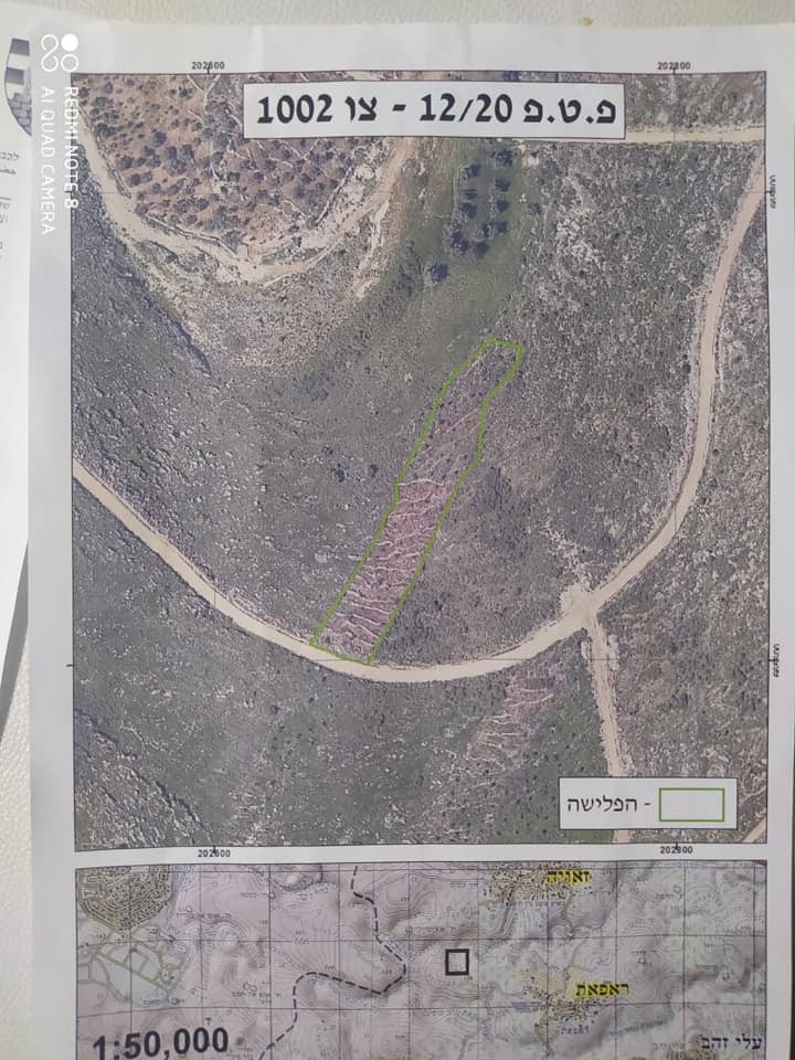
“The land of Khallet al-Hamaymeh is located near the Apartheid wall and cultivated with field crops and olive trees. It is owned by four farmers from the village according to official papers. Since the establishment of the Apartheid Wall on parts of the village’s lands in 2002, the occupation authorities have obstructed farmers ’access to their lands there under security pretexts. With the passage of time, the owners of the land began to return to their lands, rehabilitate it and re-cultivate it, prompting the occupation authorities to issue evacuation orders against an area estimated at 33 dunums under the pretext that it is government property. According to the military notices No. 001003 and 001002 attached to the detailed maps, the occupation has set a period of maximum 45 days to get the land evacuated and restored to its previous state by the owners, otherwise the occupation will take upon itself the task and force the four owners to pay the costs of the evacuation”.
 Photos 4-7: Copies of the evacuation orders of the lands of Rafat village
The targeted land is owned by the following citizens:
1- Mr. Basem Sabti Ayyash.
2- Mr. Nashit Sabati Ayyash.
3- Mr. Abdul-Latif Satti Ayyash.
4- Ms. Amira Sati Ayyash – an inheritance from her father.
Mr. Nashit Ayyash, one of the owners of the targeted land, told the Land Research Center’s researcher the following: “For 20 years, I had been working on 30 dunums of land owned by me and my brothers and about two years ago we got it planted with 240 olive seedlings”.
For his part, Mr. Abdul Latif Satti Ayyash, one of the farmers who received an evacuation notice, told the Researcher of the Land Research Center the following:
“Me and my sister own a 3 dunum piece of land in Khalat al-Hamaymah which are planted with 56 olive trees whose ages range between 13-17 years.”
A glimpse on Rafat Village:
The village of Rafat is located 20 km to the west of the city of Salfit. It is bordered on the north by Al Zawiya, on the west by the Green Line, on the east by Kafr El Deek, and on the south by Deir Ballut. It is besieged on the south side by the colony of “Har Eli Zahav”.
The village has a population of 2522 people. Its total area is 8,731 dunums, of which 393 dunums are a built-up are. The occupation confiscated an area of 402 dunums of its lands, as followed:
- An area of 102 dunums were captured in 1986 for the construction of the settlement of Mitzur Atiqa;2-
- An area of 300 dunums were destroyed under the path of the Wall whose length is three km, and 4,180 dunams were taken inside it.
The lands of the village are classified according to the Oslo Agreement as followed:
- Areas classified as B (794 dunums(.
- Areas classified as C (7,937 dunums).


