• About The Project
  • Palestine in Century
  • Selected Maps
  • Glossary
  • About ARIJ
  • About LRC
  • By Year
    • Case Studies By Year
    • Daily Report By Year
Tuesday, October 14, 2025
POICA
No Result
View All Result
  • Home
  • Settlements
    • New Israeli Settlements
    • Settlement Expansion
  • Israeli Violations
    • Agriculture
    • Confiscation
    • Demolition
    • Environment
    • Eviction of Palestinians
    • Settlers Attacks
  • Bypass Roads
  • Israeli Plans
  • Segregation
    • Checkpoints
    • Closure
    • Separation Plans
  • Military Orders
  • Reports
    • Daily Report
    • Monthly Report
    • Quarterly Report
No Result
View All Result
POICA
No Result
View All Result

The Geopolitics of Bethlehem Governorate

May 7, 2020
in Israeli Violations
The Geopolitics of Bethlehem Governorate


The Geopolitical Status of Bethlehem Governorate

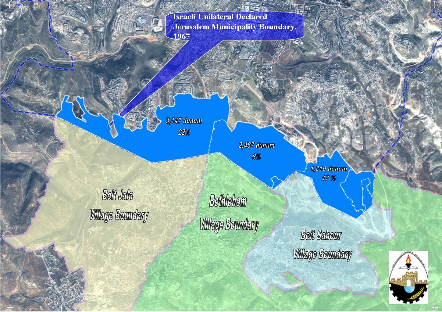
Bethlehem Governorate lies in the southern part of the West Bank south of Jerusalem. It has an area of 658.6 Km2 and is home to 217,400 Palestinian inhabitants (PCBS, 2017). It has been targeted by the Israeli occupation since 1967 when 18.1 Km2 from its lands were unilaterally annexed by Israel to the illegally declared new municipal boundary of Jerusalem. However, since 1967, the owners of the “annexed areas” continued to access their land until the Segregation Wall plan came to existence.

To read full Report, click here 


Prepared by:  
The Applied Research Institute – Jerusalem

Recommended For You

تصعيد إسرائيلي جديد: الاحتلال يهدم مبنى في بيت لحم ويواصل سياسة التطهير المكاني

by arij
August 12, 2025
0
تصعيد إسرائيلي جديد: الاحتلال يهدم مبنى في بيت لحم ويواصل سياسة التطهير المكاني

في استمرار لسياسة الهدم والتضييق التي تنتهجها سلطات الاحتلال الإسرائيلي بحق الفلسطينيين وممتلكاتهم، نفذت آليات وجرافات تابعة لقوات الاحتلال، صباح اليوم الأربعاء 6 آب 2025، عملية هدم واسعة...

Read moreDetails

Villages and Communities of Masafer Yatta: A Model of the Forced Displacement of Palestinian Communities in Area “C”

by arij
August 2, 2025
0
Villages and Communities of Masafer Yatta: A Model of the Forced Displacement of Palestinian Communities in Area “C”

Introduction: Since its occupation of the West Bank in 1967, Israel has pursued a long-term policy aimed at minimizing Palestinian presence in Area “C”, which constitutes approximately 61%...

Read moreDetails

قرى وتجمعات مسافر يطا: نموذج تهجير التجمعات الفلسطينية في المنطقة “ج” سياسة ممنهجة لاقتلاع الوجود الفلسطيني

by arij
August 6, 2025
0
قرى وتجمعات مسافر يطا: نموذج تهجير التجمعات الفلسطينية في المنطقة “ج” سياسة ممنهجة لاقتلاع الوجود الفلسطيني

مقدمة: منذ احتلالها للضفة الغربية عام 1967، تنتهج إسرائيل سياسة طويلة الأمد تهدف إلى تقليص الوجود الفلسطيني في المناطق المصنفة "ج"، التي تشكل ما نسبته 61% من الضفة...

Read moreDetails

قرية النعمان ضحية خطوة تهويديه أخرى: بلدية القدس الإسرائيلية تستهدف ديمغرافيا الوجود الفلسطيني

by arij
August 6, 2025
0

في خطوة تصعيدية جديدة ضمن سلسلة من الإجراءات التهويدية، أخطرت سلطات الاحتلال الإسرائيلي بتاريخ الثلاثين من تموز 2025 كافة منازل قرية النعمان الواقعة شمال شرق بيت لحم وجنوب...

Read moreDetails

Nu’man Village: A Victim of another Judaization Campaign

by arij
August 2, 2025
0
Nu’man Village: A Victim of another Judaization Campaign

In a new escalation within a systematic Judaization campaign, Israeli municipality of Jerusalem issued mass demolition orders on July 30, 2025, targeting all homes in the village of...

Read moreDetails
Next Post

ARIJ Daily Report – Mon, 6th 03 2020

LATEST NEWS

محافظة أريحا على خريطة المصادرة الإسرائيلية- إسرائيل تسعى للاستحواذ على أكثر من 7000 دونم في منطقة النبي موسى

محافظة أريحا على خريطة المصادرة الإسرائيلية- إسرائيل تسعى للاستحواذ على أكثر من 7000 دونم في منطقة النبي موسى

by arij
October 13, 2025
0

........................................................

ما يزيد عن 1900 دونما من الأراضي الفلسطينية في بيت لحم مهددة بالعزل لصالح مستوطنة افراتا

ما يزيد عن 1900 دونما من الأراضي الفلسطينية في بيت لحم مهددة بالعزل لصالح مستوطنة افراتا

by arij
October 8, 2025
0

........................................................

Annexation of the Jordan Valley: Implications for the Two-State Solution and Regional Stability

Annexation of the Jordan Valley: Implications for the Two-State Solution and Regional Stability

by arij
September 29, 2025
0

........................................................

Isolation of Three Villages Northwest of Jerusalem: Silent Annexation Creeps toward the Capital

عزل ثلاث قرى فلسطينية شمال غرب مدينة القدس: الضم الاسرائيلي الصامت يزحف نحو محيط العاصمة

by arij
September 24, 2025
0

........................................................

flag_yellow_lowEU-PfP-Logo

This website and its content were initiated in 1993 by the Applied Research Institute – Jerusalem (ARIJ) and the Land Research Center (LRC) with the support from the European Union up until 2023. Since then, the Applied Research Institute – Jerusalem (ARIJ) has taken over the continued development and maintenance of the website. The views expressed remain solely those of ARIJ) and do not necessarily reflect those of the European Union.

© 2025 Copyright ARIJ . All Rights reserved. .

No Result
View All Result
  • Home
  • Settlements
    • New Israeli Settlements
    • Settlement Expansion
  • Israeli Violations
    • Agriculture
    • Confiscation
    • Demolition
    • Environment
    • Eviction of Palestinians
    • Settlers Attacks
  • Bypass Roads
  • Israeli Plans
  • Segregation
    • Checkpoints
    • Closure
    • Separation Plans
  • Military Orders
  • Reports
    • Daily Report
    • Monthly Report
    • Quarterly Report

© 2025 Copyright ARIJ . All Rights reserved. .