• About The Project
  • Palestine in Century
  • Selected Maps
  • Glossary
  • About ARIJ
  • About LRC
  • By Year
    • Case Studies By Year
    • Daily Report By Year
Friday, October 3, 2025
POICA
No Result
View All Result
  • Home
  • Settlements
    • New Israeli Settlements
    • Settlement Expansion
  • Israeli Violations
    • Agriculture
    • Confiscation
    • Demolition
    • Environment
    • Eviction of Palestinians
    • Settlers Attacks
  • Bypass Roads
  • Israeli Plans
  • Segregation
    • Checkpoints
    • Closure
    • Separation Plans
  • Military Orders
  • Reports
    • Daily Report
    • Monthly Report
    • Quarterly Report
No Result
View All Result
POICA
No Result
View All Result

Eviction order on 4 dunums of agricultural lands in Khirbet Jubara/ Tulkarim governorate

September 26, 2019
in Military Orders
Eviction order on 4 dunums of agricultural lands in Khirbet Jubara/ Tulkarim governorate


  • Violation: A military order to evict lands.
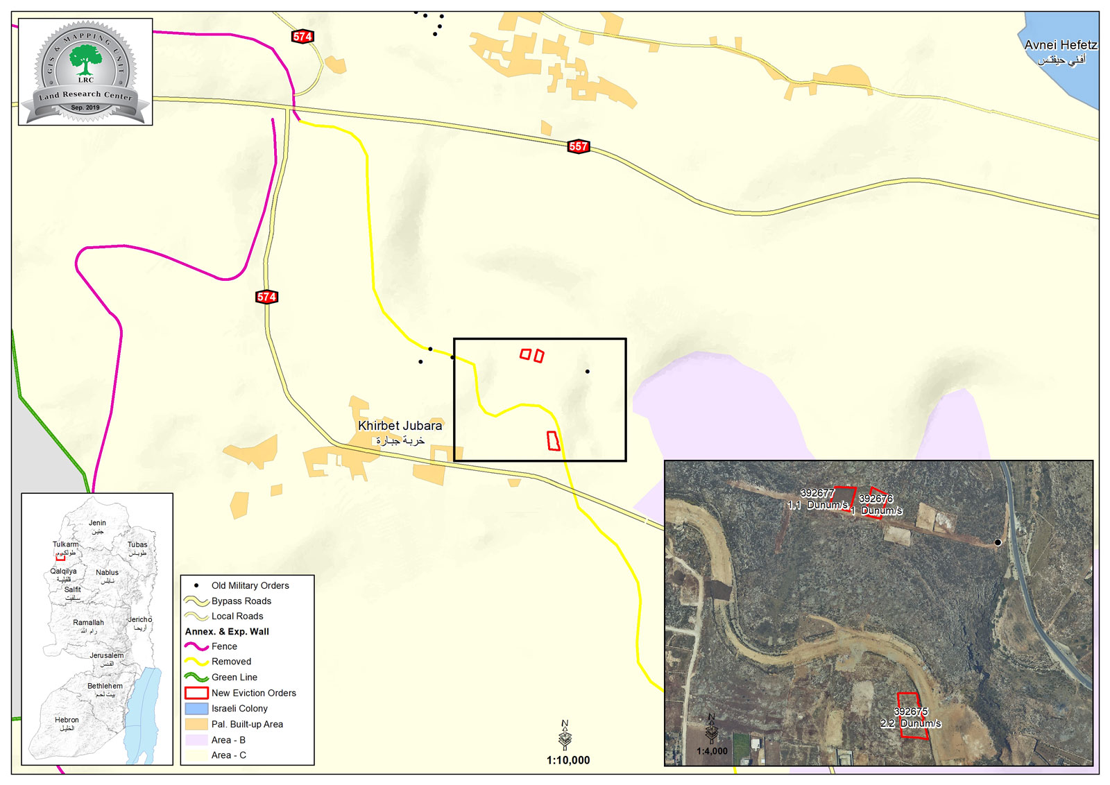
  • Location: Khirbet Jubara / South Tulkarim city.
  • Date: 09/07/2019.
  • Perpetrator: The Israeli occupation civil administration.
  • Victims: 3 Palestinian families.

Description:

A vehicle related to the government properties department in the civil administration raided Khirbet Jubara south Tulkarim city, and put eviction notices on three plots under claims that they are government properties, the owners were given only 45 days to evict their lands. The targeted plots are located in an area known as “Khallet Hmaid” in natural block 2 , piece 78 of Ar-Ras village . The following table shows information about the damages as reported:

Affected citizen

location

Nature of the targeted land

Number of family members

Area in dunums

Military order number

Yusif Mitani

natural block 2 , piece 78

Unused

9

2.2

392675

Mohammad Yassin

Unused

6

1

392676

Hussam Al-Qasim

Unused

8

1.1

392677

total

23

4.3


Village council head Mustafa Al-Abushi told LRC reporter:

“The targeted land owned by farmers from Khirbet Jubara and surrounding villages, the plots were cultivated with a variety of crops such as wheat and lentil, and provided a sub side source of income for several families, but after the construction of the apartheid wall between 2000-2002 farmers became exposed to Israeli restrictions under claims that their plots are adjacent to the apartheid wall, Israeli troops completely destroyed the crop several times. With continuous pressure, the occupation authorities dismantled part of the apartheid wall in 2013 , which also caused harm to vast areas of lands that the occupation now claim are government properties.”

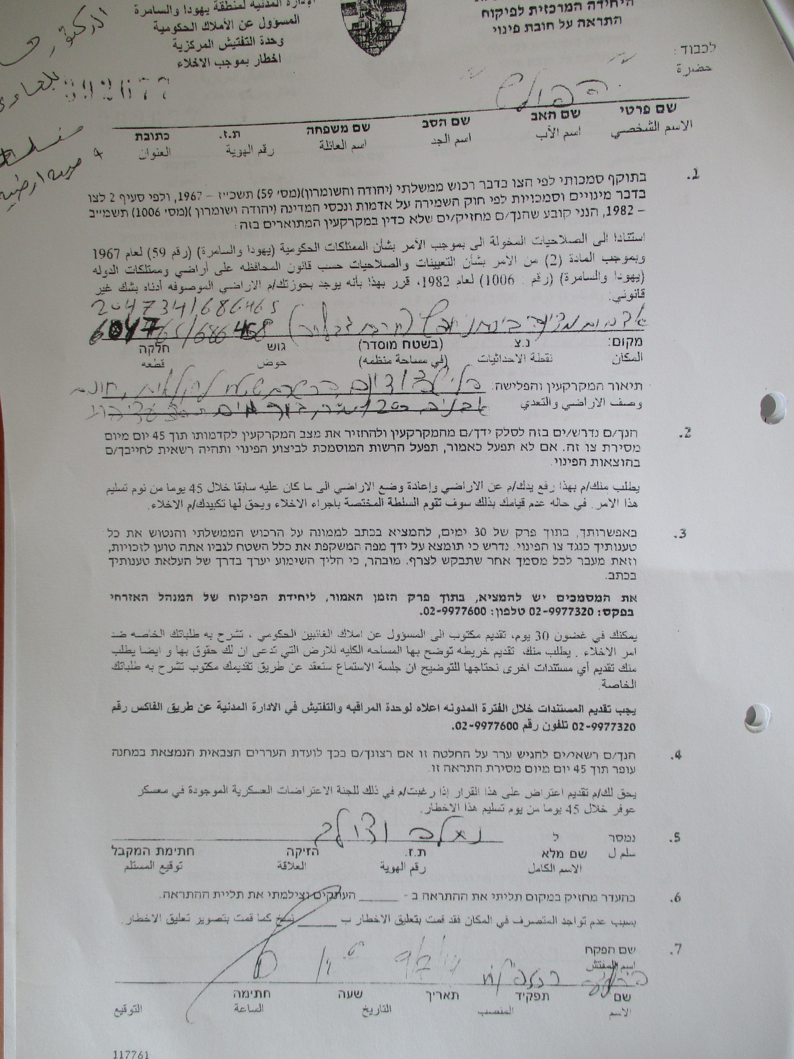
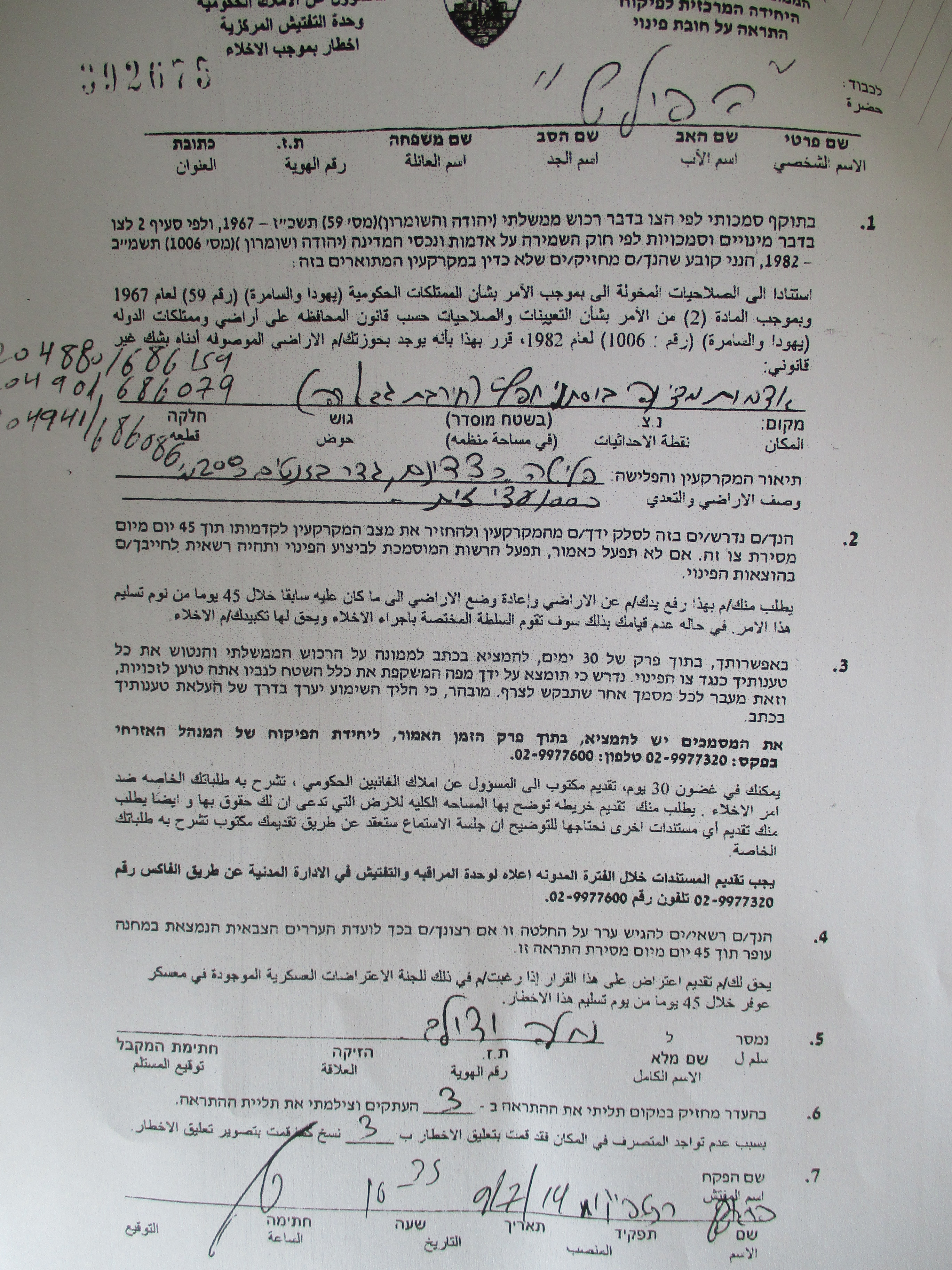
Photos 1-3: the notices

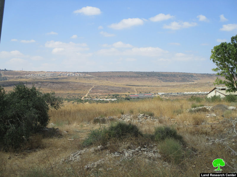
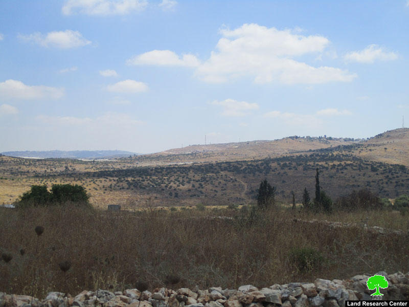
Photo 4-5: the targeted location

About Jubara:[1]

7 km to the south of Tulkarem city , Jubara is border by Faro’un village (north), occupied territories of 1948 (west), Shofa village (east), Kafl Al-Jamal and Flamiy (south) . Its population mounts to 313 according to 2017 census.

Families of the town: Jubara, Mahmoud, Awad and Odeh. The town has a total area of 46,914 dunums , of which 73 dunums are the town’s built up area.

Israeli settlements devoured 1068 dunums of the town’s land:

  • Sal’it settlement (1977)  devourd 921 dunums and populated 441 settlers.
  • Ya’arit devoured 147 dunums.

The segregation wall devoured 1531 dunums, and isolated 12,212 dunums.

Oslo conventions divided Jubara into B and C areas:

  • B area : 29862 dunums.
  • C area: 17052 dunums.


[1] GIS-LRC


Prepared by

 The Land Research Center
LRC

Recommended For You

سلطات الاحتلال الإسرائيلي تستغل ‘المنفعة العامة’ لنهب الموارد الفلسطينية

by arij
September 30, 2025
0
سلطات الاحتلال الإسرائيلي تستغل ‘المنفعة العامة’ لنهب الموارد الفلسطينية

في الاول من شهر ايلول من العام 2025، نشرت الإدارة المدنية الإسرائيلية، الذراع الأيمن لحكومة الاحتلال الإسرائيلي أمرا عسكريا جديدا تحت عنوان " أمر ءبشأن قانون الأراضي (الاستملاك...

Read moreDetails

The Occupation Targets the Village of Raba Southeast of Jenin with Military Orders and Seizes Vast Areas of Its Lands

by arij
September 13, 2025
0
الاحتلال يستهدف بأوامر عسكرية قرية رابا جنوب شرق جنين ويصادر مساحات واسعة من أراضيها

 The Israeli occupation Army have continued their policy of plundering Palestinian lands, as their bulldozers leveled wide areas of agricultural land in the village of Raba, southeast of...

Read moreDetails

الاحتلال يستهدف بأوامر عسكرية قرية رابا جنوب شرق جنين ويصادر مساحات واسعة من أراضيها

by arij
September 13, 2025
0
الاحتلال يستهدف بأوامر عسكرية قرية رابا جنوب شرق جنين ويصادر مساحات واسعة من أراضيها

  واصلت قوات الاحتلال الإسرائيلي سياسة نهب الأراضي الفلسطينية، حيث أقدمت آلياتها على تجريف أراض زراعية واسعة في قرية رابا جنوب شرق محافظة جنين، تمهيدا لشق شارع عسكري...

Read moreDetails

Nablus Governorate’s Archaeological Sites Face Israeli Expropriation Plans

by arij
September 11, 2025
0
” المواقع الأثرية في محافظة نابلس… ساحة مفتوحة أمام مخططات المصادرة الإسرائيلية “

On 10 August, 2025, the Israeli Civil Administration (ICA), issued a booklet of military orders signed by the head of the so-called ‘Israeli Civil Administration’ in the occupied...

Read moreDetails

” المواقع الأثرية في محافظة نابلس… ساحة مفتوحة أمام مخططات المصادرة الإسرائيلية “

by arij
August 26, 2025
0
” المواقع الأثرية في محافظة نابلس… ساحة مفتوحة أمام مخططات المصادرة الإسرائيلية “

في العاشر من شهر اب من العام 2025, أصدرت الإدارة المدنية الإسرائيلية كراسة أوامر عسكرية موقعة من قبل رئيس ما يسمى "بالإدارة المدنية الإسرائيلية" في الضفة الغربية المحتلة,...

Read moreDetails
Next Post

ARIJ Daily Report – Tue, 9th 07 2019

LATEST NEWS

Annexation of the Jordan Valley: Implications for the Two-State Solution and Regional Stability

Annexation of the Jordan Valley: Implications for the Two-State Solution and Regional Stability

by arij
September 29, 2025
0

........................................................

Isolation of Three Villages Northwest of Jerusalem: Silent Annexation Creeps toward the Capital

عزل ثلاث قرى فلسطينية شمال غرب مدينة القدس: الضم الاسرائيلي الصامت يزحف نحو محيط العاصمة

by arij
September 24, 2025
0

........................................................

Isolation of Three Villages Northwest of Jerusalem: Silent Annexation Creeps toward the Capital

Isolation of Three Villages Northwest of Jerusalem: Silent Annexation Creeps toward the Capital

by arij
September 24, 2025
0

........................................................

سياسات التهويد في القدس: من السيطرة المكانية إلى طمس الهوية عبر التسمية

سياسات التهويد في القدس: من السيطرة المكانية إلى طمس الهوية عبر التسمية

by arij
September 23, 2025
0

........................................................

flag_yellow_lowEU-PfP-Logo

This website and its content were initiated in 1993 by the Applied Research Institute – Jerusalem (ARIJ) and the Land Research Center (LRC) with the support from the European Union up until 2023. Since then, the Applied Research Institute – Jerusalem (ARIJ) has taken over the continued development and maintenance of the website. The views expressed remain solely those of ARIJ) and do not necessarily reflect those of the European Union.

© 2025 Copyright ARIJ . All Rights reserved. .

No Result
View All Result
  • Home
  • Settlements
    • New Israeli Settlements
    • Settlement Expansion
  • Israeli Violations
    • Agriculture
    • Confiscation
    • Demolition
    • Environment
    • Eviction of Palestinians
    • Settlers Attacks
  • Bypass Roads
  • Israeli Plans
  • Segregation
    • Checkpoints
    • Closure
    • Separation Plans
  • Military Orders
  • Reports
    • Daily Report
    • Monthly Report
    • Quarterly Report

© 2025 Copyright ARIJ . All Rights reserved. .