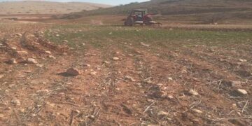
- Violation: Settlers take over wide areas of pastoral lands.
- Location: Wad Al-Malih / Tubas governorate.
- Date: 10/03/2019.
- Perpetrator: Illegal Israeli settlers.
- Victims: Farmers and herders in Wad Al-Malih.
Description:
New Judaization scheme that aims to impose facts on the ground; Israeli settlers take over wide areas of pastoral lands through surrounding them with a siege, in order to keep Palestinian herders and their herds out of the area.
The real owners of the lands are Palestinians, who were displaced with guns held to their heads in 1967-1969.
The targeted lands lie in the following locations: (Al-Fao hamlets, Ein Al-Hilwa and Umm Al-Jamal east Wad Al-Malih area), accurately down the hill that links “Rotem” and “Mesekot” settlements.
The responsible on colonization file in Tubas governorate told LRC reporter:
“There is an accelerated operation to take over the lands that surround Israeli settlements and the occupation’s military camps, the occupation’s government gave the green light for settlers gangs to grab Palestinian lands and surrounding them with sieges to keep their owners out, and use them in the near future for colonial expansion.
We, In Tubas Governor’s office with Human-Rights institutions work closely in order to support the steadfastness of rural and Bedouin communities in threatened areas”
In the same context, settlers’ gangs escalated their attacks on farmers of Wad Al-Malih and surrounding hamlets. In addition, The Israeli occupation army were seen harassing farmers , arresting them , and threatening them that they will be harmed if they used these postures again.
Herder Abdulraheem Bsharat told LRC reporter:
“While number of herders were in Al-Faresiya , a group of settlers raided the area on a tractor then started harassing farmers in order to force them out the area, farmer Khaleel Daraghmeh (19) called the Israeli police and informedthem about the attack, the police came by, arrested Daraghmeh for 8 hours and tortured him.”
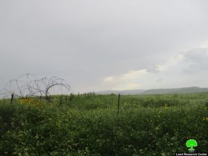
 Photos 1-2: the siege that surrounds the targeted land
Photo 3-4: the targeted areas
 Photo 5: a view of Mesekot settlement
The Land Research Center
LRC


