The Israeli occupation Army (IOA) began relocating the military checkpoint located at the northern entrance of al-Walajeh village west of Bethlehem city to a new location, beyond the 1949 Armistice Line (Green Line). On the 14th of February, 2018, the Israeli bulldozers escorted by the Israeli occupation Army (IOA) began leveling Palestinian lands in Al Walajeh village, in “Iraq Swedan," area, preparing for the relocation of Al Walajeh checkpoint (the so-called Ein Yael checkpoint). The new Israeli military checkpoint will be placed 2.5 km inside the lands of Al Walajeh village, to its west, and will cause the isolation of the ancient Ein Haniya spring (which provides recreation, bathing and picnicking for Palestinians in Al Walajeh village and the surrounding communities of Beit Jala and Bethlehem cities) and thousands of dunums of Palestinian agricultural lands surrounding it.
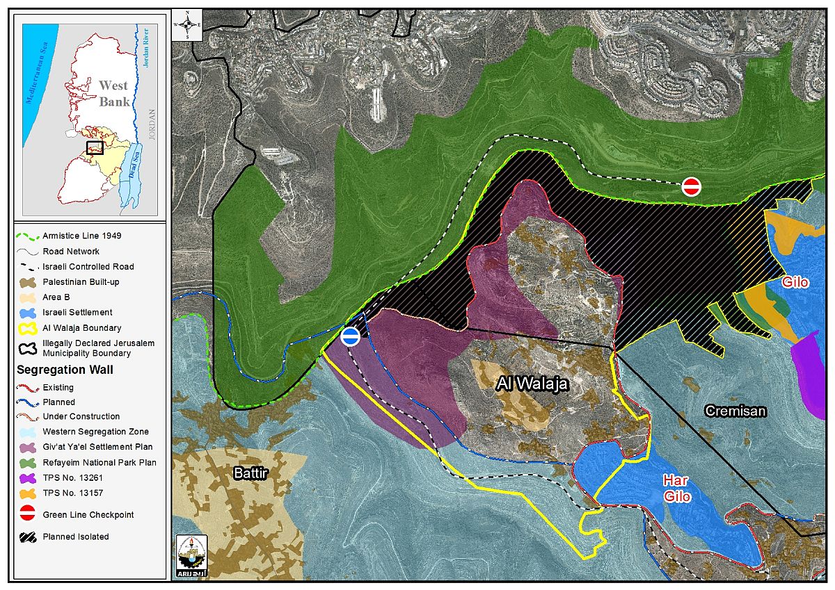
Earlier in November 2017, Palestinians in the village of al-Walajeh, northwest of Bethlehem city, were informed that they will be cut off from their farmland due to the Israeli Jerusalem district planning panel’s decision to relocate Al Walajeh checkpoint (the so-called Ein Yael checkpoint) located at Al Walajeh’s northern entrance, to a new location, to its west. The relocation of the checkpoint will shift a large area of Al Walajeh village lands[1] to become under the jurisdiction of the Israeli side. See Map 1

Map 1: The relocation of Al Walajeh checkpoint
Al Walajeh checkpoint or the so-called Ein Yael checkpoint is located on the road between Jerusalem and Bethlehem. Following the construction of the Israeli Segregation wall on lands of Al Walajeh village, a large area of land became somewhat isolated from its Palestinian land owners (between the route of the wall and Al Walajeh checkpoint (north of Al Walajeh); Palestinians could access these lands on seasonal bases since the construction of the wall is not completed in the area. Palestinians could also access Al Walajeh checkpoint to go to Jerusalem. However, the relocation of the Checkpoint deep inside the lands of Al Walajeh village will make these lands TOTALLY off access to Palestinians including the ancient Ein Hanya spring; Furthermore, Palestinians will no longer be able to cross the checkpoint to go to Jerusalem; sealing it off from its surroundings and eventually DENYING Palestinians access to their farm lands.
A historical glance
Following the Israeli occupation of the West Bank including East Jerusalem and the Gaza Strip in the year 1967, Israel unilaterally declared a new municipal boundary for the city of Jerusalem, where it expanded from 6.5 km² to 71 km² to include lands from nearby Palestinian villages and Towns. These lands where then annexed to the state of Israel.
Part of Al Walajeh village, a total land area of 2251 dunums were annexed to the unilaterally redrawn Jerusalem Municipality Boundary, including the Ein Haniya spring and the lands surrounding it and part of the Palestinian built-up area in the village, Ein Al Juwaiza neighborhood.
It was until year 2000 that Palestinians in Al Walajeh village and the surrounding communities could fully access the area despite being part of the illegally redrawn Jerusalem Municipality Boundary. Palestinians were also able to access Jerusalem city through Al Walajeh’s northern entrance/exit (known today as Al Walajeh checkpoint or the so-called Ein Yael Checkpoint) with no restrictions; however, following the start of the second Intifada back in September 2000, Israel tightened its grip on the occupied Palestinian territory and intensified the closure over the occupied Palestinian territory, more closely regulating the travel of Palestinian citizens and enforcing a system of movement restrictions through permanent checkpoints, roadblocks, gates, closed roads, barriers, and the construction of the Israeli Segregation Wall.
The Israeli closure policy was mainly focused on the Jerusalem area and the areas surrounding it, in an attempt to control the movement of Palestinians into and out of the city, thus placing checkpoints and crossing borders at the entrances/exits leading to the city and limiting the entry of Palestinian to it. Only Palestinians with valid Israeli permits enabling them to enter the city of Jerusalem, Palestinian Jerusalemites (Palestinians who hold Jerusalem ID cards- Blue Cards) and internationals, have been able to access the city; Palestinians with West Bank ID cards were denied access to the city.
Later in June 2002, the Israeli Government launched its infamous policy of unilateral segregation within the occupied State of Palestine by establishing a Segregation Zone along the western terrains of the occupied West Bank. The area west of the Segregation Wall that reaches to the 1949 Armistice Line (Green Line) and covers substantial and significant land areas, rich with natural resources (water aquifers) as it runs along the western part of the West Bank from north to south, seizing the most fertile agricultural lands, isolating Palestinian communities in enclaves, undermining the territorial contiguity between the Palestinian villages and cities, controlling the natural resources, and encapsulating and protecting most of the illegal Israeli settlements.
Al Walajeh village was of no exception as the Israeli Segregation wall will run around 7 km on its land (around 57% of its total length has been completed – See Table 1) and will cut it off from Jerusalem area in the first place that is addition to isolating more than 2200 dunums of its lands, to become on the Isrseli side of the wall, and off access to Palestinian land owners. See Table 1 for details about the stages of construction of the Israeli Segregation Wall.
|
Table 1: Status of the Israeli SEGREGATION Wall on lands of Al Walajeh Village |
|||
|
No. |
Wall type |
Length (km) |
% of total length |
|
1 |
Existing Wall |
3.981 |
57.1 |
|
2 |
Planned Wall |
2.125 |
30.5 |
|
3 |
Under-construction Wall |
0.861 |
12.4 |
|
Total Length |
6.967 |
100 |
|
|
Source: ARIJ Geo-informatics Department, 2018 |
|||
Segregation and Isolation
The systematic nature of Israel's occupation policies (including the Segregation Wall) submits it to a further violation to the Human Rights and international law and comprises a crime of apartheid according to the International Convention on the Suppression and Punishment of the Crime of Apartheid (1973). Moreover, the crime of Apartheid comprises a 'crime against humanity' and 'a serious threat to international peace and security. It is a flagrant violation of international humanitarian law, specifically The Hague Regulations of 1907 and the Fourth Geneva Convention of 1949:
- The Hague Regulations expressly forbids an occupying power 'to destroy or seize the enemy's property, unless such destruction or seizure be imperatively demanded by the necessities of war' (Article 23).
- Article 53 of the Fourth Geneva Convention is also clear that: 'any destruction by the Occupying Power of real or personal property belonging individually or collectively to private persons, or to the State, or to other public authorities, or to social or cooperative organizations, is prohibited, except where such destruction is rendered absolutely necessary by military operations.'
- The appropriation and destruction of Palestinian land is an especially serious violation of the Fourth Geneva Convention, Article 147 of which clearly prohibits, ''extensive destruction and appropriation of property, not justified by military necessity and carried out unlawfully and wantonly.'' Violations of Articles of the Fourth Geneva Convention constitute grave breaches of the Convention and should be prosecuted as War Crimes.
[1] Estimated at 1500 dunums of lands – temporarily accessed by Palestinians today due to the construction of the Israeli Segregation Wall but will become off access once the construction of the wall is completed on lands of the village
Prepared by:
The Applied Research Institute – Jerusalem


