• About The Project
  • Palestine in Century
  • Selected Maps
  • Glossary
  • About ARIJ
  • About LRC
  • By Year
    • Case Studies By Year
    • Daily Report By Year
Wednesday, August 20, 2025
POICA
No Result
View All Result
  • Home
  • Settlements
    • New Israeli Settlements
    • Settlement Expansion
  • Israeli Violations
    • Agriculture
    • Confiscation
    • Demolition
    • Environment
    • Eviction of Palestinians
    • Settlers Attacks
  • Bypass Roads
  • Israeli Plans
  • Segregation
    • Checkpoints
    • Closure
    • Separation Plans
  • Military Orders
  • Reports
    • Daily Report
    • Monthly Report
    • Quarterly Report
No Result
View All Result
POICA
No Result
View All Result

Israeli Occupation Forces demolish a residence and notify another of stop-work in Ramallah

December 27, 2017
in Demolition, Israeli Violations, Military Orders

Violation: demolishing a house and notifying another

Location:  Ni'lin town-  Ramallah governorate

Date:  November 16, 2017

Perpetrators: Israel Civil Administration

Victims:  Citizen Mohammad Ghaythan


Details:

 A massive force from the Israeli occupation accompanied by a staff from the so-called Civil Administration and a military dozer raided on November 16, 2017 the area known as "Al-Mhallal", south Ni'lin village in Ramallah and conducted a demolition operation.

Reportedly, the bulldozer demolished a 240m2 house owned by citizen Mohammad Ghaythan. The house built three years  accommodated the citizen's eight member family including six children.

It should be noted that the owner received a stop-work order on the house in November 2015. The notice was served on the claim of "unlicensed construction", taking into account that the house is only 150 meters away from Kiryat Asfar colony.

Allegedly, the occupation claimed delivering a demolition order for the owner one week before the demolition took place.


Photos 1-3: the rubbles of Mohammad's residences

Stop-work order:

In the same context, the attacking force served the same citizen a stop-work order on a house he owns 30 meters away from the demolished house.

Reportedly, the targeted house ( 240m2) is of two floors, the second is still under construction.

According to the military order, the affected owner was given an eleven day deadline to complete all licensing producers related to the house. This deadline comes in time with the hearing session of the Planning and Construction Committee- Israel Civil Administration in Beit El colony to consider the legal status of the notified structure.


Photo 4: the targeted house

Noteworthy,  Al-Mhallal area witnessed – during the last couple of years- vicious targeting and attacks carried out by the occupation forces with the aim of destroying the area's economy.
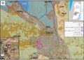
About Ni'lin:

20 km to the northwest of Ramallah, Ni'lin is edged by the towns of Qibya and Budrus from the north, Al-Midyah town from the southwest, Deir Qidees town from the east and Mod'in and Kiryat Sefer colonies from the south.

Ni'lin is inhabited by 5897 people on a total land area of 15,206 dunums , of which 748 dunums are the village's built-up area.

The occupation confiscated a total of 3020 dunums for colonial ends, which are detailed as follows:

  • Hashmona'im colony: it was established in 1985 on confiscated area of 858 dunums from the village. It is now inhabited by 2097 colonists.
  • Kiryat Sefer: it was established in 1991 on confiscated area of 476 dunums from the village. It is now inhabited by 24,290 colonists.
  • Mattityahu colony: it was established in 1980 on confiscated area of 657 dunums from the village. It is now inhabited by 1365 colonists.
  • Colonial bypass road number 446 confiscated 408 dunums 
  • The apartheid wall confiscated 621 dunums for the favor of its construction and isolated 14,083 behind it.


According to Oslo Accords lands classifications, Ni'lin lands are classified as follows:

  • 1,123 dunums are classified as area "B"
  • 14,083 dunums are classified as area "C"


Land Research Center LRC sees that demolitions contradict with all of the International conventions and Humanitarian laws including:

  1. Article 17 of the (1948) Universal Declaration of Human Rights stating: “Everyone has the right to own property alone as well as in association with others. No one shall be arbitrarily deprived of his property.”
  2. Section ‹G› of article 23 of the (1907) The Hague Conventions asserting: “In addition to the prohibitions provided by special Conventions, it is especially forbidden to destroy or seize the enemy's property, unless such destruction or seizure be imperatively demanded by the necessities of war.”
  3. Article 53 of the Geneva Fourth Convention (1948) declaring: “Any destruction by the Occupying Power of real or personal property belonging individually or collectively to private persons, or to the State, or to other public authorities, or to social or cooperative organizations, is prohibited, except where such destruction is rendered absolutely necessary by military operations.”
  4. Section 1, Article 11 of the International Covenant on Economic, Social and Cultural Rights (1966): “The States Parties to the present Covenant recognize the right of everyone to an adequate standard of living for himself and his family, including adequate food, clothing and housing, and to the continuous improvement of living conditions. The States Parties will take appropriate steps to ensure the realization of this right, recognizing to this effect the essential importance of international co-operation based on free consent."


Prepared by
 The Land Research Center
LRC
 

Recommended For You

“سيطرة من تحت الأرض”, بواقع 108 أمرا عسكريا, سيطرة اسرائيلية على مياه الفلسطينيين في الضفة الغربية المحتلة

by arij
August 12, 2025
0
بواقع 86 أمرا عسكريا – الأوامر العسكرية الإسرائيلية, الأداة الرئيسية للاحتلال الاسرائيلي للسيطرة على المياه الفلسطينية في الضفة الغربية المحتلة

مقدمة، لطالما شكّلت أزمة المياه إحدى القضايا الأكثر صعوبة في الأراضي الفلسطينية المحتلة، إلا أنها في العقود القليلة الماضية اتخذت منحًنا تصاعديًا خطيرًا، حتى بلغت مستويات غير مسبوقة....

Read moreDetails

تصعيد إسرائيلي جديد: الاحتلال يهدم مبنى في بيت لحم ويواصل سياسة التطهير المكاني

by arij
August 12, 2025
0
تصعيد إسرائيلي جديد: الاحتلال يهدم مبنى في بيت لحم ويواصل سياسة التطهير المكاني

في استمرار لسياسة الهدم والتضييق التي تنتهجها سلطات الاحتلال الإسرائيلي بحق الفلسطينيين وممتلكاتهم، نفذت آليات وجرافات تابعة لقوات الاحتلال، صباح اليوم الأربعاء 6 آب 2025، عملية هدم واسعة...

Read moreDetails

Villages and Communities of Masafer Yatta: A Model of the Forced Displacement of Palestinian Communities in Area “C”

by arij
August 2, 2025
0
Villages and Communities of Masafer Yatta: A Model of the Forced Displacement of Palestinian Communities in Area “C”

Introduction: Since its occupation of the West Bank in 1967, Israel has pursued a long-term policy aimed at minimizing Palestinian presence in Area “C”, which constitutes approximately 61%...

Read moreDetails

قرى وتجمعات مسافر يطا: نموذج تهجير التجمعات الفلسطينية في المنطقة “ج” سياسة ممنهجة لاقتلاع الوجود الفلسطيني

by arij
August 6, 2025
0
قرى وتجمعات مسافر يطا: نموذج تهجير التجمعات الفلسطينية في المنطقة “ج” سياسة ممنهجة لاقتلاع الوجود الفلسطيني

مقدمة: منذ احتلالها للضفة الغربية عام 1967، تنتهج إسرائيل سياسة طويلة الأمد تهدف إلى تقليص الوجود الفلسطيني في المناطق المصنفة "ج"، التي تشكل ما نسبته 61% من الضفة...

Read moreDetails

قرية النعمان ضحية خطوة تهويديه أخرى: بلدية القدس الإسرائيلية تستهدف ديمغرافيا الوجود الفلسطيني

by arij
August 6, 2025
0

في خطوة تصعيدية جديدة ضمن سلسلة من الإجراءات التهويدية، أخطرت سلطات الاحتلال الإسرائيلي بتاريخ الثلاثين من تموز 2025 كافة منازل قرية النعمان الواقعة شمال شرق بيت لحم وجنوب...

Read moreDetails
Next Post

ARIJ Daily Report – Thu, 16th 11 2017

LATEST NEWS

مشروع (E1): الضربة القاضية لحل الدولتين وإعادة تشكيل الخريطة الجيوسياسية للضفة الغربية

The Government Pushes Forward Plans in E1, Considered a Death Blow to the Two-State Solution

by arij
August 16, 2025
0

........................................................

مشروع (E1): الضربة القاضية لحل الدولتين وإعادة تشكيل الخريطة الجيوسياسية للضفة الغربية

مشروع (E1): الضربة القاضية لحل الدولتين وإعادة تشكيل الخريطة الجيوسياسية للضفة الغربية

by arij
August 16, 2025
0

........................................................

بواقع 86 أمرا عسكريا – الأوامر العسكرية الإسرائيلية, الأداة الرئيسية للاحتلال الاسرائيلي للسيطرة على المياه الفلسطينية في الضفة الغربية المحتلة

“سيطرة من تحت الأرض”, بواقع 108 أمرا عسكريا, سيطرة اسرائيلية على مياه الفلسطينيين في الضفة الغربية المحتلة

by arij
August 12, 2025
0

........................................................

تصعيد إسرائيلي جديد: الاحتلال يهدم مبنى في بيت لحم ويواصل سياسة التطهير المكاني

تصعيد إسرائيلي جديد: الاحتلال يهدم مبنى في بيت لحم ويواصل سياسة التطهير المكاني

by arij
August 12, 2025
0

........................................................

flag_yellow_lowEU-PfP-Logo

This website has been produced with the assistance of the European Union. The contents of this publication are the sole responsibility of ARIJ & LRC and can in no way be taken to reflect the views of the European Union.

© 2025 Copyright ARIJ . All Rights reserved. .

No Result
View All Result
  • Home
  • Settlements
    • New Israeli Settlements
    • Settlement Expansion
  • Israeli Violations
    • Agriculture
    • Confiscation
    • Demolition
    • Environment
    • Eviction of Palestinians
    • Settlers Attacks
  • Bypass Roads
  • Israeli Plans
  • Segregation
    • Checkpoints
    • Closure
    • Separation Plans
  • Military Orders
  • Reports
    • Daily Report
    • Monthly Report
    • Quarterly Report

© 2025 Copyright ARIJ . All Rights reserved. .