• About The Project
  • Palestine in Century
  • Selected Maps
  • Glossary
  • About ARIJ
  • About LRC
  • By Year
    • Case Studies By Year
    • Daily Report By Year
Monday, April 6, 2026
POICA
No Result
View All Result
  • Home
  • Settlements
    • New Israeli Settlements
    • Settlement Expansion
  • Israeli Violations
    • Agriculture
    • Confiscation
    • Demolition
    • Environment
    • Eviction of Palestinians
    • Settlers Attacks
  • Bypass Roads
  • Israeli Plans
  • Segregation
    • Checkpoints
    • Closure
    • Separation Plans
  • Military Orders
  • Reports
    • Daily Report
    • Monthly Report
    • Quarterly Report
No Result
View All Result
POICA
No Result
View All Result

The Israeli Occupation Forces ravage lands after seizure in Bethlehem governorate

January 31, 2018
in Agriculture, Israeli Violations
The Israeli Occupation Forces ravage lands after seizure in Bethlehem governorate

Violation: ravaging lands

Location:  Al-Jab'a village

Date:  August 09, 2017

Perpetrators: the Israeli Occupation Forces

Victims:  residents of the village


Details:

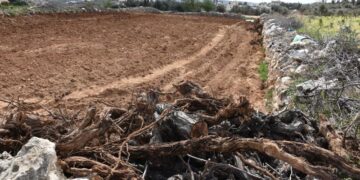
The Israeli occupation machineries ravaged on August 09, 2017 some 13 agricultural dunums from the lands of Al-Jab'a village on the claim of "Security Purposes".

Reportedly, the lands are located within the natural blocks number 2 from the locations of Marah Rabah, Al-Hur and Marah Al-Bir in Al-Jab'a area and Khallet Mohammad Salameh in Surif town.

Photos 1-4: the ravaging works in Al-Jab'a area

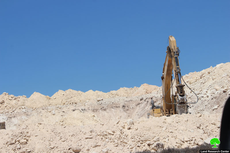
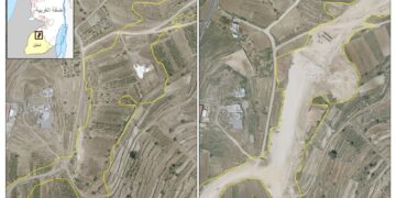
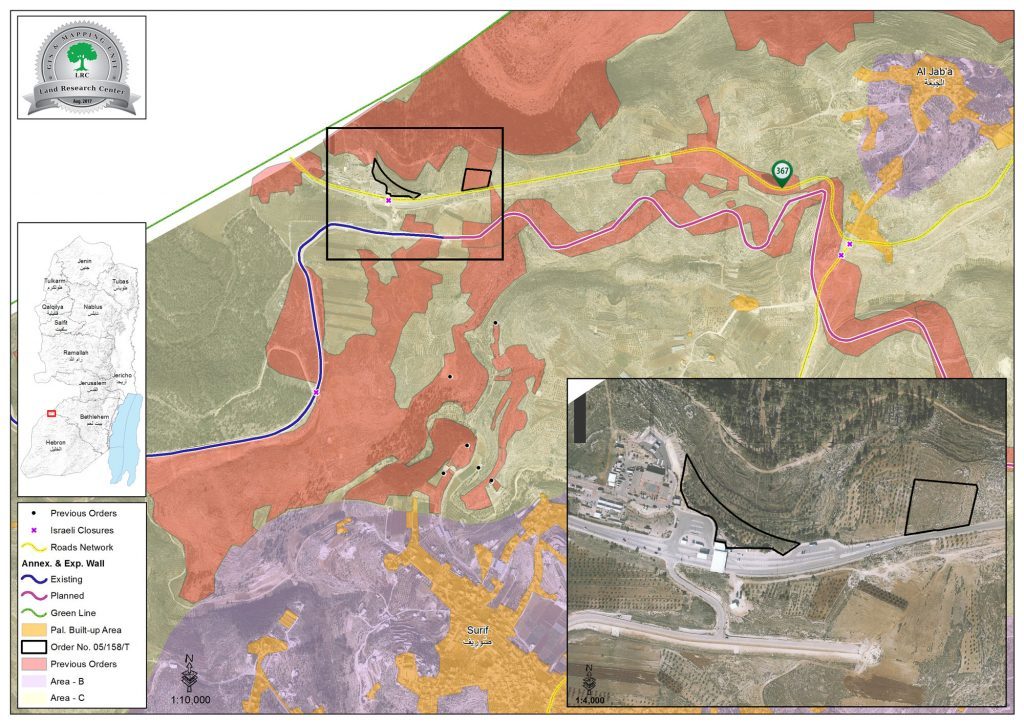
Photo 5: location of the attack

Noteworthy, Israeli Occupation Authorities issued on June 01, 2017 a military seizure order targeting 12 dunums of Al-Jab'a lands, southwest Bethlehem governorate. More specifically, the lands are founded within the natural block number two.

The seizure was justified on the claim of maintaining security and aborting attacks, the Israeli army said.

It is said that the occupation intends to expand "Haleh" terminal that is founded on confiscated lands from Al-Jab'a area.

The targeted lands are reported to be cultivated with 150 olive trees since forty years. Owners of the land possess Ottoman ownership documents on the lands.


It is reported that the ravaging works supervised and protected by the Israeli Occupation Forces present all time in the area.

Banning farmers from accessing their lands will cast negative shadows on the economic status of the area and will badly affect the agricultural sector. Not only, owners of lands will eventually lose their lands for colonists interests.

About Al-Jab’a:

It is located 25 km to the northwest of Hebron city. It is edged by the villages of Nahhalin and Wadi Fukin in Bethlehem from the north, Surif in Hebron from the south and the armistice line from the west.

 The village has a total area of 7968 dunums, of which 153 dunums are built-up area, where 876 people live (2007 census).


The Israeli colony of Tsoref confiscated around 468 dunums from the village's lands, it was established in 1989 and is inhabited by 767 colonists.

The bypass road number 367 confiscated more than 514 dunums, where the annexation and isolation wall destroyed 340 dunums under its construction.


According to Oslo Accords lands classifications, Al-Jab'a lands are classified as follows:


  • 300 dunums ( 4%) are classified as area "B", which is under Palestinian Authority control 
  • 7655 dunums (96 %)are classified as area "C", Which is under full Israeli Authority control

Prepared by
 The Land Research Center
LRC
 

Recommended For You

الاحتلال الإسرائيلي يستهدف مشاريع تنموية في قرية جورة الشمعة جنوب شرق بيت لحم

by arij
March 14, 2026
0
الاحتلال الإسرائيلي يستهدف مشاريع تنموية في قرية جورة الشمعة جنوب شرق بيت لحم

في يوم الاربعاء الموافق الرابع من شهر اذار من العام من العام 2026, سلمت سلطات الاحتلال الاسرائيلي (الإدارة المدنية الاسرائيلية) أهالي قرية جورة الشمعة جنوب شرق مدينة بيت...

Read moreDetails

The West Bank: Between Settler Aggression and Occupation Support – 2025 Highlights

by arij
March 25, 2026
0
The West Bank: Between Settler Aggression and Occupation Support – 2025 Highlights

In the occupied West Bank (oWB), the violence committed by Israeli settlers is no longer a series of isolated, random attacks; it has effectively become a de facto...

Read moreDetails

Palestinian Trees … Victims of the Israeli Occupation Army and Settler groups in 2025

by arij
March 25, 2026
0
Palestinian Trees … Victims of the Israeli Occupation Army and Settler groups in 2025

Preface, In the occupied West Bank, the uprooting of Palestinian trees is not merely an assault on nature and environment; it is an act that strikes Palestinian culture,...

Read moreDetails

الضفة الغربية بين إرهاب المستوطنين وتواطؤ الاحتلال – حصيلة العام 2025

by arij
February 16, 2026
0
الضفة الغربية بين إرهاب المستوطنين وتواطؤ الاحتلال – حصيلة العام 2025

مقدمة: - في الضفة الغربية المحتلة، يتعدى عنف المستوطنين الإسرائيليين كونه سلسلة اعتداءات عشوائية تتم دون نهج معين، بل أصبح يشكّل سياسة أمر واقع تفرض بقوة السلاح على...

Read moreDetails

الأشجار الفلسطينية -جريمة بلا صوت – ضحية مزدوجة لجيش الاحتلال الاسرائيلي والمستوطنين خلال العام 2025

by arij
February 16, 2026
0
الأشجار الفلسطينية -جريمة بلا صوت – ضحية مزدوجة لجيش الاحتلال الاسرائيلي والمستوطنين خلال العام 2025

في الضفة الغربية المحتلة، لا يُعتبر اقتلاع الأشجار الفلسطينية مجرد اعتداء على الطبيعة والبيئة، بل هو فعلٌ يمس الثقافة والتاريخ والوجود الفلسطيني اذ يستهدف الإنسان والأرض معًا. فمنذ...

Read moreDetails
Next Post
إضافة 10 كرفانات استعمارية متنقلة على أراضي قرية نحالين بمحافظة بيت لحم

إضافة 10 كرفانات استعمارية متنقلة على أراضي قرية نحالين بمحافظة بيت لحم

LATEST NEWS

سلطات الاحتلال الإسرائيلي تستهدف قرية الجيب بأمر عسكري جديد

سلطات الاحتلال الإسرائيلي تستهدف قرية الجيب بأمر عسكري جديد

by arij
March 17, 2026
0

........................................................

على ما مساحته 1006.4 دونما من أراضي بلدة يانون  “سلطات الاحتلال الإسرائيلي تشرع بتغيير نفوذ بؤرة استيطانية في الضفة الغربية المحتلة”

على ما مساحته 1006.4 دونما من أراضي بلدة يانون
“سلطات الاحتلال الإسرائيلي تشرع بتغيير نفوذ بؤرة استيطانية في الضفة الغربية المحتلة”

by arij
March 14, 2026
0

........................................................

الاحتلال الإسرائيلي يستهدف مشاريع تنموية في قرية جورة الشمعة جنوب شرق بيت لحم

الاحتلال الإسرائيلي يستهدف مشاريع تنموية في قرية جورة الشمعة جنوب شرق بيت لحم

by arij
March 14, 2026
0

........................................................

سلطات الاحتلال الإسرائيلي تستخدم الأوامر العسكرية لتعمق المشروع الاستيطاني في الضفة الغربية المحتلة

سلطات الاحتلال الإسرائيلي تستخدم الأوامر العسكرية لتعمق المشروع الاستيطاني في الضفة الغربية المحتلة

by arij
February 26, 2026
0

........................................................

flag_yellow_lowEU-PfP-Logo

This website and its content were initiated in 1993 by the Applied Research Institute – Jerusalem (ARIJ) and the Land Research Center (LRC) with the support from the European Union up until 2023. Since then, the Applied Research Institute – Jerusalem (ARIJ) has taken over the continued development and maintenance of the website. The views expressed remain solely those of ARIJ) and do not necessarily reflect those of the European Union.

© 2026 Copyright | ARIJ | All Rights reserved.

No Result
View All Result
  • Home
  • Settlements
    • New Israeli Settlements
    • Settlement Expansion
  • Israeli Violations
    • Agriculture
    • Confiscation
    • Demolition
    • Environment
    • Eviction of Palestinians
    • Settlers Attacks
  • Bypass Roads
  • Israeli Plans
  • Segregation
    • Checkpoints
    • Closure
    • Separation Plans
  • Military Orders
  • Reports
    • Daily Report
    • Monthly Report
    • Quarterly Report

© 2026 Copyright | ARIJ | All Rights reserved.