• About The Project
  • Palestine in Century
  • Selected Maps
  • Glossary
  • About ARIJ
  • About LRC
  • By Year
    • Case Studies By Year
    • Daily Report By Year
Friday, October 3, 2025
POICA
No Result
View All Result
  • Home
  • Settlements
    • New Israeli Settlements
    • Settlement Expansion
  • Israeli Violations
    • Agriculture
    • Confiscation
    • Demolition
    • Environment
    • Eviction of Palestinians
    • Settlers Attacks
  • Bypass Roads
  • Israeli Plans
  • Segregation
    • Checkpoints
    • Closure
    • Separation Plans
  • Military Orders
  • Reports
    • Daily Report
    • Monthly Report
    • Quarterly Report
No Result
View All Result
POICA
No Result
View All Result

Israeli Occupation Forces notify residences of stop-work in the Salfit town of Kfar Ad-Dik

January 16, 2018
in Military Orders
Israeli Occupation Forces notify residences of stop-work in the Salfit town of Kfar Ad-Dik
  • Violation: issuing stop-work orders on residences
  • Location:  Kfar Ad-Dik- Salfit governorate
  • Date:  March 20, 2017
  • Perpetrators: Planning and Construction Committee- Israel Civil Administration
  • Victims:  seven Palestinian families

Details:

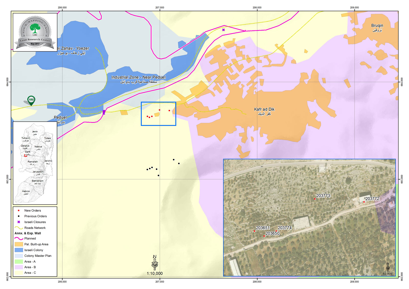
The so-called Planning and Construction Committee- Israel Civil Administration delivered on March 20, 2017 stop-work orders for seven families from Kfar Ad-Dik town, west Salfit governorate. The orders targeted seven residences on the claim of them being built in area classified "C" according to Oslo Accords.

Noteworthy, the targeted residences are founded in the area known as Al-Khalayeel, west of the town.

According to the orders, the affected owners were given a deadline until March 30, 2017 to complete all licensing procedures. This comes in time with the hearing session of the Planning and Construction Committee- Israel Civil Administration in the court of Beit El colony to consider the legal status of the notified structures. The following table shows information about the affected people and their properties:

Affected citizen

Family

Minors

No. of order

Nature of targeted structure

Photo

Ahmad Bakr Ahmad

11

5

203773

Under construction two story house (13m2 each floor)

1

Raed Ahmad

4

2

203772

145m2 house

2

Radiya Naji

6

4

203651

60m2 under construction basement

3

Sumia Ahmad

7

3

203774

90m2 under construction house

4

Ashraf Naji

3

1

203650

110m2 house

5

Yazeed Ahmad

8

2

N/A

Agricultural residences (60m2)

6

Ibrahim Ahmad

5

3

N/A

Agricultural residences (60m2)

7


44

20


Source : Field observation- Department of Monitoring Israeli Violations- Land Research Center-2017


It should be noted that Kfar Ad-Dik town as other Palestinian villages, cities and camps suffers from the Israeli escalation of attacks and violations against basic rights including the right to housing .  By 2000,  more than 20 residences were served stop-work orders on the claim of them being location in area classified "C" according to Oslo Accords. Despite that owners of structures apply for building permits, Israeli Occupation Authorities never grant them such licenses for Palestinians.

Kfar ad Dik [i]

Kfar ad Dik is located 15 km to the west of Salfit. It is surrounded by Bidya (north), Rafat and Deir Ballut (west), Bruqin and Sarta (east), and Bani Zaid villages (south). Kfar ad Dik has a population of 4553 people, according to a 2007 census.  Its total area is 15529 dunums; however, it has been suffocated by bypasses and 3 Israeli colonies that lay over its lands. This has further limited its expansion knowing that it had already had a 791-dunum organizational plan (built-up area); it also isolated the village from its surroundings. The Israeli occupation confiscated 2477 dunums of Kfar ad Dik lands for the benefit of:

  1. Colonies devoured 1225 dunums, and they are:

Name of colony

Year of construction

Area of confiscated land/ dunum

Number of colonists

Har Eli Zahav

 1983

 134

NA

Eli Zahav- Yoezer

1982

 290

424

Bedoel

1984

800

1088

  •  Bruchin

1999

  1. 1

NA

  •  


*Source: Field Research- Monitoring Israeli Violations Team- Land Research Centre (LRC).

  1. Bypasses stole 362 dunums
  2. The Apartheid Wall seized 890 dunums and isolated 8824 dunums and is expected to be 8905 long in Kfar ad Dik lands.

Lands of Kfar ad-Dik are categorized according to Oslo Accords into lands under Area B (15% of the lands) and lands under Area C (85% of the lands).

i] Source: Geographic Information System- Monitoring Israeli Violations Team- Land Research Center


Prepared by
 The Land Research Center
LRC
 

Recommended For You

سلطات الاحتلال الإسرائيلي تستغل ‘المنفعة العامة’ لنهب الموارد الفلسطينية

by arij
September 30, 2025
0
سلطات الاحتلال الإسرائيلي تستغل ‘المنفعة العامة’ لنهب الموارد الفلسطينية

في الاول من شهر ايلول من العام 2025، نشرت الإدارة المدنية الإسرائيلية، الذراع الأيمن لحكومة الاحتلال الإسرائيلي أمرا عسكريا جديدا تحت عنوان " أمر ءبشأن قانون الأراضي (الاستملاك...

Read moreDetails

The Occupation Targets the Village of Raba Southeast of Jenin with Military Orders and Seizes Vast Areas of Its Lands

by arij
September 13, 2025
0
الاحتلال يستهدف بأوامر عسكرية قرية رابا جنوب شرق جنين ويصادر مساحات واسعة من أراضيها

 The Israeli occupation Army have continued their policy of plundering Palestinian lands, as their bulldozers leveled wide areas of agricultural land in the village of Raba, southeast of...

Read moreDetails

الاحتلال يستهدف بأوامر عسكرية قرية رابا جنوب شرق جنين ويصادر مساحات واسعة من أراضيها

by arij
September 13, 2025
0
الاحتلال يستهدف بأوامر عسكرية قرية رابا جنوب شرق جنين ويصادر مساحات واسعة من أراضيها

  واصلت قوات الاحتلال الإسرائيلي سياسة نهب الأراضي الفلسطينية، حيث أقدمت آلياتها على تجريف أراض زراعية واسعة في قرية رابا جنوب شرق محافظة جنين، تمهيدا لشق شارع عسكري...

Read moreDetails

Nablus Governorate’s Archaeological Sites Face Israeli Expropriation Plans

by arij
September 11, 2025
0
” المواقع الأثرية في محافظة نابلس… ساحة مفتوحة أمام مخططات المصادرة الإسرائيلية “

On 10 August, 2025, the Israeli Civil Administration (ICA), issued a booklet of military orders signed by the head of the so-called ‘Israeli Civil Administration’ in the occupied...

Read moreDetails

” المواقع الأثرية في محافظة نابلس… ساحة مفتوحة أمام مخططات المصادرة الإسرائيلية “

by arij
August 26, 2025
0
” المواقع الأثرية في محافظة نابلس… ساحة مفتوحة أمام مخططات المصادرة الإسرائيلية “

في العاشر من شهر اب من العام 2025, أصدرت الإدارة المدنية الإسرائيلية كراسة أوامر عسكرية موقعة من قبل رئيس ما يسمى "بالإدارة المدنية الإسرائيلية" في الضفة الغربية المحتلة,...

Read moreDetails
Next Post

ARIJ Daily Report – Mon, 20th 03 2017

LATEST NEWS

Annexation of the Jordan Valley: Implications for the Two-State Solution and Regional Stability

Annexation of the Jordan Valley: Implications for the Two-State Solution and Regional Stability

by arij
September 29, 2025
0

........................................................

Isolation of Three Villages Northwest of Jerusalem: Silent Annexation Creeps toward the Capital

عزل ثلاث قرى فلسطينية شمال غرب مدينة القدس: الضم الاسرائيلي الصامت يزحف نحو محيط العاصمة

by arij
September 24, 2025
0

........................................................

Isolation of Three Villages Northwest of Jerusalem: Silent Annexation Creeps toward the Capital

Isolation of Three Villages Northwest of Jerusalem: Silent Annexation Creeps toward the Capital

by arij
September 24, 2025
0

........................................................

سياسات التهويد في القدس: من السيطرة المكانية إلى طمس الهوية عبر التسمية

سياسات التهويد في القدس: من السيطرة المكانية إلى طمس الهوية عبر التسمية

by arij
September 23, 2025
0

........................................................

flag_yellow_lowEU-PfP-Logo

This website and its content were initiated in 1993 by the Applied Research Institute – Jerusalem (ARIJ) and the Land Research Center (LRC) with the support from the European Union up until 2023. Since then, the Applied Research Institute – Jerusalem (ARIJ) has taken over the continued development and maintenance of the website. The views expressed remain solely those of ARIJ) and do not necessarily reflect those of the European Union.

© 2025 Copyright ARIJ . All Rights reserved. .

No Result
View All Result
  • Home
  • Settlements
    • New Israeli Settlements
    • Settlement Expansion
  • Israeli Violations
    • Agriculture
    • Confiscation
    • Demolition
    • Environment
    • Eviction of Palestinians
    • Settlers Attacks
  • Bypass Roads
  • Israeli Plans
  • Segregation
    • Checkpoints
    • Closure
    • Separation Plans
  • Military Orders
  • Reports
    • Daily Report
    • Monthly Report
    • Quarterly Report

© 2025 Copyright ARIJ . All Rights reserved. .