• About The Project
  • Palestine in Century
  • Selected Maps
  • Glossary
  • About ARIJ
  • About LRC
  • By Year
    • Case Studies By Year
    • Daily Report By Year
Thursday, October 16, 2025
POICA
No Result
View All Result
  • Home
  • Settlements
    • New Israeli Settlements
    • Settlement Expansion
  • Israeli Violations
    • Agriculture
    • Confiscation
    • Demolition
    • Environment
    • Eviction of Palestinians
    • Settlers Attacks
  • Bypass Roads
  • Israeli Plans
  • Segregation
    • Checkpoints
    • Closure
    • Separation Plans
  • Military Orders
  • Reports
    • Daily Report
    • Monthly Report
    • Quarterly Report
No Result
View All Result
POICA
No Result
View All Result

Israeli authorities order agricultural lands evacuated in Wad Qana area

June 5, 2017
in Military Orders
إخطار بإخلاء أراضي زراعية في منطقة واد قانا بحجة أنها محمية طبيعية ؟!!


  • Violation: evacuation order on lands
  • Location:  Wad Qana area- Salfit governorate
  • Date:  February 07, 2017
  • Perpetrators: Israel Nature Authority
  • Victims:  three Palestinian families

Details:

 The so-called officer of Israel Nature Authority accompanied by Israeli Occupation Forces raided on February 07, 2017 Wad Qana area, north Salfit governorate and delivered three evacuation orders for the owners of lands in there. The orders mentioned the uprooting of 200 olive seedlings planted a year ago and the demolishing of 136m of retaining walls in addition to the removing of two plastic tanks (1m3 each).

The orders were reported served on the claim of the targeted items being founded in area classified as "natural reserve" by the Israelis.  The affected owners were given a seven day deadline to carry out the order otherwise the occupation forces would do the job and all expenses will be billed to the farmers.

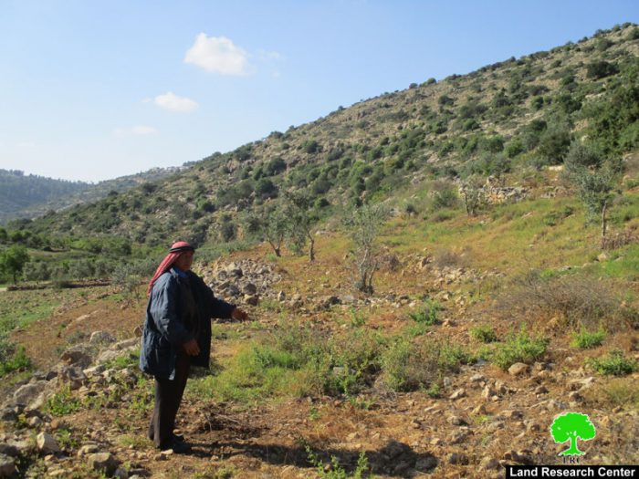
Photos 1-4: one of the targeted plots


The following table shows information about the affected people and properties:

Affected citizen

Family

Minors

Area of targeted plot

Nature of damage

No. of order

Baker Awwad

7

2

3.5

Demolition of 70m of retaining walls

Uprooting 60olive trees (3years)

Removal of water tank (1m3)

2152

Abdelaziz Aqel

5

0

3

Demolition of 31 of retaining walls

Uprooting 70olive trees (3years)


2151

Riziq Naser

6

3

4

Demolition of 65m of retaining walls

Uprooting 70olive trees (3years)

Removal of water tank (1m3)

N/A

Total

18

5

10.5


Source : Field observation- Department of Monitoring Israeli Violations- Land Research Center-2017


Since 1967, Israeli Occupation Forces declared the area of Wad Qana (10,000 dunums) as a natural reserve, where Palestinian are banned from using the area whatsoever. Not only, the Israeli Occupation filled the area with colonies, which did not stop expanding ever since that date. Hundreds of agricultural dunums were stolen from Palestinian for the sake of expanding the existing colonies in Wad Qana. Other massive areas were taken to open roads and networks to connect all colonies of the area one with the other.

Over the past couple of years, the Israeli occupation issued a series of military orders to confiscate hundreds of other dunums from Wad Qana for the favor of expanding Yakir and Revava colonies at the expense of Palestinian private lands.

About Wad Qana:

It is located 10km to the northwestern part of Deir Istiya and surrounded by: Jinsafut, Kfar Laqif and Azzun from the east, and  Kfar Thulth form the west. The valley overlooks "Yakir" colony from the southern side and is near to "Nofim" colony.

Wad Qana is relative to the village of Deir Istiya (34,129 dunums) and has a total land area of 10,000 dunums, of which 13 dunums are built-up area. Worth mentioning, the place is planted with citrus, olives, and field crops.

The area is a natural slope that is located between two mountains and is famous for water abundance and soil fertility.

The lands of Deir Istiya are classified, according to Oslo accords as follows:

  • Area B: it totals around 6132 dunums (18% of the village's total area)
  • Area C : it totals around 27997 dunums (82% of the village's total area)
  • Noteworthy, Wad Qana lands are all classified as area C.


Prepared by
 The Land Research Center
LRC
 

Recommended For You

ما يزيد عن 1900 دونما من الأراضي الفلسطينية في بيت لحم مهددة بالعزل لصالح مستوطنة افراتا

by arij
October 8, 2025
0
ما يزيد عن 1900 دونما من الأراضي الفلسطينية في بيت لحم مهددة بالعزل لصالح مستوطنة افراتا

في الثاني من شهر تشرين أول من العام 2025، أصدرت سلطات الاحتلال الإسرائيلي أمرًا عسكريًا جديدًا يحمل الرقم (ت/3/25) تحت عنوان "تعديل حدود – يهودا والسامرة، 5785-2025". ويأتي...

Read moreDetails

سلطات الاحتلال الإسرائيلي تستغل ‘المنفعة العامة’ لنهب الموارد الفلسطينية

by arij
September 30, 2025
0
سلطات الاحتلال الإسرائيلي تستغل ‘المنفعة العامة’ لنهب الموارد الفلسطينية

في الاول من شهر ايلول من العام 2025، نشرت الإدارة المدنية الإسرائيلية، الذراع الأيمن لحكومة الاحتلال الإسرائيلي أمرا عسكريا جديدا تحت عنوان " أمر ءبشأن قانون الأراضي (الاستملاك...

Read moreDetails

The Occupation Targets the Village of Raba Southeast of Jenin with Military Orders and Seizes Vast Areas of Its Lands

by arij
September 13, 2025
0
الاحتلال يستهدف بأوامر عسكرية قرية رابا جنوب شرق جنين ويصادر مساحات واسعة من أراضيها

 The Israeli occupation Army have continued their policy of plundering Palestinian lands, as their bulldozers leveled wide areas of agricultural land in the village of Raba, southeast of...

Read moreDetails

الاحتلال يستهدف بأوامر عسكرية قرية رابا جنوب شرق جنين ويصادر مساحات واسعة من أراضيها

by arij
September 13, 2025
0
الاحتلال يستهدف بأوامر عسكرية قرية رابا جنوب شرق جنين ويصادر مساحات واسعة من أراضيها

  واصلت قوات الاحتلال الإسرائيلي سياسة نهب الأراضي الفلسطينية، حيث أقدمت آلياتها على تجريف أراض زراعية واسعة في قرية رابا جنوب شرق محافظة جنين، تمهيدا لشق شارع عسكري...

Read moreDetails

Nablus Governorate’s Archaeological Sites Face Israeli Expropriation Plans

by arij
September 11, 2025
0
” المواقع الأثرية في محافظة نابلس… ساحة مفتوحة أمام مخططات المصادرة الإسرائيلية “

On 10 August, 2025, the Israeli Civil Administration (ICA), issued a booklet of military orders signed by the head of the so-called ‘Israeli Civil Administration’ in the occupied...

Read moreDetails
Next Post
الإعلان عن إيداع مخططات جديدة لصالح مستعمرة “كوخاف يعقوب” على حساب الأراضي الفلسطينية

الإعلان عن إيداع مخططات جديدة لصالح مستعمرة "كوخاف يعقوب" على حساب الأراضي الفلسطينية

LATEST NEWS

Annexation of the Jordan Valley: Implications for the Two-State Solution and Regional Stability

الرئاسة الثانية لترامب: فرصة متجددة لطموحات إسرائيل التوسعية – ضم غور الأردن والتداعيات على حل الدولتين واستقرار المنطقة

by arij
October 14, 2025
0

........................................................

محافظة أريحا على خريطة المصادرة الإسرائيلية- إسرائيل تسعى للاستحواذ على أكثر من 7000 دونم في منطقة النبي موسى

محافظة أريحا على خريطة المصادرة الإسرائيلية- إسرائيل تسعى للاستحواذ على أكثر من 7000 دونم في منطقة النبي موسى

by arij
October 13, 2025
0

........................................................

ما يزيد عن 1900 دونما من الأراضي الفلسطينية في بيت لحم مهددة بالعزل لصالح مستوطنة افراتا

ما يزيد عن 1900 دونما من الأراضي الفلسطينية في بيت لحم مهددة بالعزل لصالح مستوطنة افراتا

by arij
October 8, 2025
0

........................................................

Annexation of the Jordan Valley: Implications for the Two-State Solution and Regional Stability

Annexation of the Jordan Valley: Implications for the Two-State Solution and Regional Stability

by arij
September 29, 2025
0

........................................................

flag_yellow_lowEU-PfP-Logo

This website and its content were initiated in 1993 by the Applied Research Institute – Jerusalem (ARIJ) and the Land Research Center (LRC) with the support from the European Union up until 2023. Since then, the Applied Research Institute – Jerusalem (ARIJ) has taken over the continued development and maintenance of the website. The views expressed remain solely those of ARIJ) and do not necessarily reflect those of the European Union.

© 2025 Copyright ARIJ . All Rights reserved. .

No Result
View All Result
  • Home
  • Settlements
    • New Israeli Settlements
    • Settlement Expansion
  • Israeli Violations
    • Agriculture
    • Confiscation
    • Demolition
    • Environment
    • Eviction of Palestinians
    • Settlers Attacks
  • Bypass Roads
  • Israeli Plans
  • Segregation
    • Checkpoints
    • Closure
    • Separation Plans
  • Military Orders
  • Reports
    • Daily Report
    • Monthly Report
    • Quarterly Report

© 2025 Copyright ARIJ . All Rights reserved. .