- Violation: taking over Palestinian area
- Location: Wad Qana- Salfit governorate
- Date: May 06, 2016
- Perpetrators: Israel Ministry of Tourism
- Victims: owners of lands in Wad Qana
Details:
Israeli newspaper “Haaretz” reported on May 25 , 2016, that during the past few years the so-called “Karnei Shomron local council" along with the Israeli Ministry of Environment, the Israeli Civil Administration, and the Israeli Nature and Parks Authority have been working to promote Qana Valley (Wadi Qana) area in Salfit Governorate. Haaretz mentioned that such kind of plans are usually submitted to Public review and receive feedbacks/objections.
According to Haaretz, the plan claims that there is no intention to expropriate more private Palestinian land in the area but "Karnei Shomron local council" intends to develop archaeological sites, make accessible routes for the disabled people, preserve water resources and natural places.
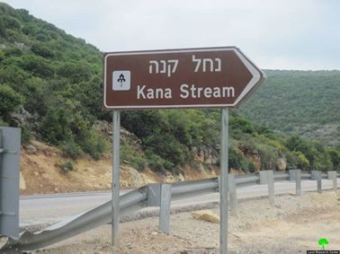
On May 16, 2016, the so-called "Karnei Shomron local council" installed signs of directions written in Hebron that are for Jewish tourists in the area in addition to setting up benches in the area of Al-Bussa and Ein Al-Fawwar. Such step is taken to initiate a takeover on the area.


Photo 1-4: the benches set up in Wad Qana
It should be marked that the Israeli occupation legislated laws relative to nature protection in the area of Wadi Qana, which is classified, by the occupation, as a natural reserve. Implementing those laws, tens of seedlings were uprooted in addition to a number of agricultural roads that were shut down under the pretext of protecting the nature.
An observer can witness the ravaging activities and lands confiscation in the area. In addition, uprooting fruitful trees for the sake of expansion is obviously seen in there. Not only that, Palestinians have been denied access to their lands compared to colonists who have the absolute right to picnic in the area under the protection of the Israeli army. Are enacted laws only to be applied on Palestinians rather than the occupation itself?
Colonists use Wadi Qana for recreational activities where Palestinian farmers are denied access to the place
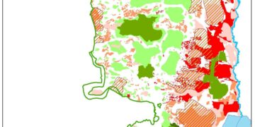
Wadi Qana is" Suffocated" by the Israeli colonies and the apartheid wall:
 Wadi Qana is surrounded by seven Israeli colonies which devour lands and cause drastic damage to the environment. These colonies are Karne Shomron, Ginat Shomron, Nov Uranium ( from north), Yakir and Nofim (from south) and Emmanuel (from east). The former colony dumps its wastewater into the valley "Wad Qana"; which polluted the water springs of (al-Juza and al-Fawwar). The wastewater reached out the pools( watersheds) of al Bussa and al-Jamal. The colony of Maale Shomron that is located to the west of Wadi Qana is forming a imminent danger on the area which lands are shrinking and whose people are being displaced within a systematic plan undertaken by colonists so they be able to expropriate Palestinian properties. In addition, the outpost Nov Uranim ,which stands in the middle of the valley, dumps its waste (solid and liquid) in the valley; which severely damaged the environment( fauna and flora) and forced many Palestinian residents to evacuate.
It is indicated that the area of planted lands in Wadi Qana has notably decreased from 10,000 dunum to 5,500 dunum because of the surrounding colonies and the occupation policy of banning famers from reaching their lands. Wadi Qana lost more than half of its agricultural lands as a result of establishing colonies on its lands. Colonists' frequent assaults on farmers, who attempt to reach their lands located in the colonies' peripheries, made the lands become arid and unsuitable for plantation.
It should be marked that the occupation confiscated around 7,590 dunums of which:
- 4,024 dunums were taken for the favor of colonies located on the lands of the Wadi
- 1,864 dunums were taken for the favor of the bypass roads no. (55,5506).
In addition, the apartheid wall destroyed about 1,702 dunums as for the wall's route of construction and segregated around 1,010 dunums behind it. After the wall's completion (17,023 m in length), an area of 18,411 dunums will be segregated behind its structure.
The following table shows information about colonies located on the lands of Wadi Qana and or\ its periphery in addition to total area of confiscated lands:
|
Colony name |
Year of establishment |
Confiscated area/dunums |
No. of colonists |
|
Revava |
1991 |
167 |
703 |
|
YAKIR |
1981 |
757 |
932 |
|
Maale Shomron |
1980 |
74 |
533 |
|
Ginat Shomron |
1985 |
944 |
(..) |
|
Karne Shomron |
1978 |
540 |
6093 |
|
Nofim |
1986 |
663 |
402 |
|
Emmanuel |
1981 |
879 |
2455 |
|
Total |
4024 |
11118 |
|
Source: Geographical Information System- Land Research Center, until 2007.
A plan to open a colonial road that links all colonies located on the lands of Wadi Qana threats more than 10,000 dunums of confiscation in the area:
On July 7th 2014, peace movement "Now" revealed a map issued by the council of colonies in the West Bank, which includes a recently prepared Israeli plan that mainly aims at bypassing around the area of Wadi Qana, north of the West Bank for the sake of Judaizing it and to firmly impose control over it. As a result, thousands of dunums will be threatened of takeover, segregation, and inaccessibility.
The plan is centered on establishing a network of bypass roads in the area of Wadi Qana, which connect all colonies of the nearby to each other. This would eventually create a regional council that unites all of the seven colonies located in the periphery of the Wadi.
According to the explanatory attached map, the plan includes shutting down a number of agricultural lands, which serve tens of agricultural dunums used by villagers and farmers since too many years ago. The roads are (Ein al-Bassa, al-Tannur, and Ein al-Fawwar).

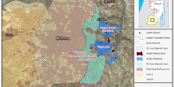
Aerial photo of the area

Wadi Qana is located 10km northwest of Salfit governorate. It is surrounded by the village of Kfar Laqif from the north, Azzun Village from the southwest and the village of Kfar Thulth from the west. The colonies of Nofim and Yakir are located there from the east where the villages of Deir Istiya and Qarawat Bani Hassan are situated there from the southeast.
The Wadi is relative to the town of Deir Istiya that is of 34,129 dunums in area, of which 10,000dunums are the overall area of Wadi Qana and 13 dunums are the town's built-up area.

The area is classified as a natural slope situated between two mountains and is famous for its beautiful nature, land fertility, and water abundance. Therefore, the occupation has been attempting on changing the landmarks of the area by conducting the strategy of lands confiscation for the sake of implementing colonial plans.
According to Oslo Accord lands classification, Deir Istiya has around 6,132 dunums (18% of the overall area of the village) that are classified as area "B" and around 27,997 dunums that are classified as area "C" (82% of the village's overall area), taking into consideration that all the lands of Wadi Qana are classified as area C.

Prepared by
The Land Research Center
LRC