• About The Project
  • Palestine in Century
  • Selected Maps
  • Glossary
  • About ARIJ
  • About LRC
  • By Year
    • Case Studies By Year
    • Daily Report By Year
Saturday, August 23, 2025
POICA
No Result
View All Result
  • Home
  • Settlements
    • New Israeli Settlements
    • Settlement Expansion
  • Israeli Violations
    • Agriculture
    • Confiscation
    • Demolition
    • Environment
    • Eviction of Palestinians
    • Settlers Attacks
  • Bypass Roads
  • Israeli Plans
  • Segregation
    • Checkpoints
    • Closure
    • Separation Plans
  • Military Orders
  • Reports
    • Daily Report
    • Monthly Report
    • Quarterly Report
No Result
View All Result
POICA
No Result
View All Result

New Wave of Demolition Orders Targeted the Palestinian Houses in the city of Qalqilyia

December 10, 2015
in Military Orders
New Wave of Demolition Orders Targeted the Palestinian Houses in the city of Qalqilyia

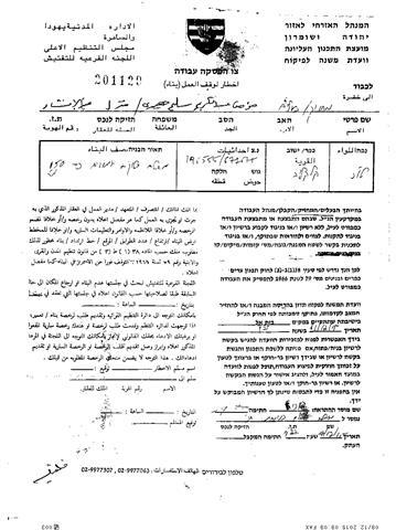
On the 7th of December 2015, the Israeli Occupation Authorities handed out military orders to stop the construction of 11 Palestinian houses located in An-Naqar neighborhood, west of Qalqiliya city.

According to Mr. Mohammad Abu Ash-Sheikh, officer in Qalqiliya governorate, the Israeli Authorities handed out the Palestinians 11 military orders that targeted houses and structures in An-Naqar neighborhood, west of Qalqiliya city, but they founded only 4 hard copies from the 11 military orders :

No. of Military orders

The owners

Area of the targeted structures

Type of the targeted structures

201138

Ahmed Rashad

20 square meters

An agricultural room

201130

Tawfeq Ahmed Ja’idi

120 square meters

An under construction house

201129

Mu’men Abed Al Karem Salem Ja’idi

150 square meters

An under construction house

201128

Sameh ‘Anayah

120 square meters

A inhabited house


The analysis done by the Geo-Informatics department in the Applied Research Institute-Jerusalem (ARIJ), showed that the four targeted houses in An-Naqar neighborhood, west of Qalqiliya city, located in areas classified as “Area C” (according to Oslo Agreement, 1995) which it under the control of the Israeli Occupation Authorities. Accordingly, the Israeli Authorities claimed that the targeted houses were built without the permits from the Israeli Civil Administration.

It should be noted that the Palestinians living in the area classified as “Area C”, which it about 60% of the total area of the occupied West Bank, suffered from the Israeli procedures against them. The Israeli Occupation Authorities prevented the Palestinians from building their houses or any other structures in that area, and when they try to build the houses, the Israeli Authorities issued the demolition orders after a period of time, before the Israeli bulldozers demolished the houses under the claim of  “illegal” houses .

It’s worth to mention that the four targeted houses located in the Israeli “Buffer zone” which it declared by the Israeli Occupation Authorities after the construction of the Israeli segregation wall. The “Buffer zone” it’s the area located along the eastern side of the segregation wall and its about 75-200 meters away from the wall. And according to the Israeli declaration, the construction are not allowed in this area and of course for the Palestinians only . According to the satellite images for the area  at least one of the targeted houses located about 100 meters away from the Israeli segregation wall.

Furthermore, the satellite photos also showed that there are a number of Palestinian houses and structures located near the targeted houses in these military orders, which means, that these houses and structures vulnerable to the demolition orders in the future.

Qalqiliya city

Qalqiliya is the only Palestinian city in Qalqiliya Governorate. It is bordered by ‘Arab Abu Farda and ‘Arab Ar Ramadin al Janubi to the east, Habla and Wadi Ar Rasha to the south, the Green Line (lands of 1948) to the west, and ‘Arab Ar Ramadin Ash Shamali and lands of 1948 to the north.

Geopolitical status in Qalqiliya city

According to the Oslo II Interim Agreement signed by the Palestinian Liberation Organization (PLO) and Israel on 28th September 1995, Qalqiliya was divided into areas “B” and “C”. Approximately 3,619 dunums (35.3. % of the city total area) were classified as area B, where the Palestinian National Authority (PNA) has complete control over civil matters but Israel continues to have overriding responsibility for security. Area B constitutes most of the inhabited Palestinian areas including municipalities, villages and some refugee camps. Most of the population of Qalqiliya resides in area B. The rest of the city area, constituting 6,633 dunums (64.7% of the total), is classified as area C, where Israel retains full control over security and administration related to the territory. In area C, Palestinian building and land management is prohibited without the prior consent or authorization of the Israeli Civil Administration. Most of the lands lying within area “C” are agricultural areas and open spaces.

For more information about Qalqiliya city: http://vprofile.arij.org/qalqiliya/pdfs/vprofile/Qalqiliya_vp_en.pdf


To Sum Up  

The Israeli Occupation Authorities aimed to use any procedures that will punish the Palestinians  living in their own land. Therefore the military orders, constitute a significant example for the Israeli procedures against the Palestinians, which aimed to force them to leave their houses and lands,  to interest of the Israeli colonial projects in the occupied Palestinian territories. 


Prepared by:  
The Applied Research Institute – Jerusalem

Recommended For You

“سيطرة من تحت الأرض”, بواقع 108 أمرا عسكريا, سيطرة اسرائيلية على مياه الفلسطينيين في الضفة الغربية المحتلة

by arij
August 12, 2025
0
بواقع 86 أمرا عسكريا – الأوامر العسكرية الإسرائيلية, الأداة الرئيسية للاحتلال الاسرائيلي للسيطرة على المياه الفلسطينية في الضفة الغربية المحتلة

مقدمة، لطالما شكّلت أزمة المياه إحدى القضايا الأكثر صعوبة في الأراضي الفلسطينية المحتلة، إلا أنها في العقود القليلة الماضية اتخذت منحًنا تصاعديًا خطيرًا، حتى بلغت مستويات غير مسبوقة....

Read moreDetails

تهويد صامت بالأمتار: الطريق إلى بني كيديم خطوة نحو الشرعنة الاستيطانية

by arij
July 16, 2025
0
تهويد صامت بالأمتار: الطريق إلى بني كيديم خطوة نحو الشرعنة الاستيطانية

في الثامن عشر من شهر حزيران من العام 2025، تسلّم أهالي بلدتي سعير والشيوخ الواقعتين شمال شرق محافظة الخليل أمراً عسكرياً إسرائيلياً جديداً يقضي بمصادرة 4.8 دونما من...

Read moreDetails

من غير شرعية إلى واقع مفروض, البؤرة الاستيطانية سدي بوعز في رعاية الاحتلال

by arij
July 15, 2025
0

في الثامن من شهر تموز من العام 2025، سلّمت سلطات الاحتلال الإسرائيلي أمرًا عسكريًا جديدًا يقضي بمصادرة أراضٍ فلسطينية وممتلكات خاصة في بلدة الخضر جنوب غرب محافظة بيت...

Read moreDetails

ملاخي هشالوم: أكثر من مجرد بؤرة استيطانية … مشروع تهويد وتوسّع اسرائيلي

by arij
July 10, 2025
0
ملاخي هشالوم: أكثر من مجرد بؤرة استيطانية … مشروع تهويد وتوسّع اسرائيلي

قامت سلطات الاحتلال الإسرائيلي بتاريخ 7 تموز 2025 بنشر أمر عسكري جديد في الضفة الغربية المحتلة، يحمل عنوان: "أمر بشأن الأملاك الحكومية (يهودا والسامرة) (رقم 59) لسنة 1967"....

Read moreDetails

Israeli Order Targets Zububa Village Under Security Claims

by arij
June 24, 2025
0
أمر عسكري إسرائيلي يستهدف أراضي قرية زبوبا الفلسطينية لأغراض أمنية مستعجلة

As part of Israel's systematic violations against Palestinian land in the occupied West Bank", the Israeli occupation authorities, on June 14, 2025, issued a new military order to...

Read moreDetails
Next Post

ARIJ Daily Report - Thu, 10th 12 2015

LATEST NEWS

” المواقع الأثرية في محافظة نابلس… ساحة مفتوحة أمام مخططات المصادرة الإسرائيلية “

” المواقع الأثرية في محافظة نابلس… ساحة مفتوحة أمام مخططات المصادرة الإسرائيلية “

by arij
August 21, 2025
0

........................................................

مشروع (E1): الضربة القاضية لحل الدولتين وإعادة تشكيل الخريطة الجيوسياسية للضفة الغربية

The Government Pushes Forward Plans in E1, Considered a Death Blow to the Two-State Solution

by arij
August 16, 2025
0

........................................................

مشروع (E1): الضربة القاضية لحل الدولتين وإعادة تشكيل الخريطة الجيوسياسية للضفة الغربية

مشروع (E1): الضربة القاضية لحل الدولتين وإعادة تشكيل الخريطة الجيوسياسية للضفة الغربية

by arij
August 16, 2025
0

........................................................

بواقع 86 أمرا عسكريا – الأوامر العسكرية الإسرائيلية, الأداة الرئيسية للاحتلال الاسرائيلي للسيطرة على المياه الفلسطينية في الضفة الغربية المحتلة

“سيطرة من تحت الأرض”, بواقع 108 أمرا عسكريا, سيطرة اسرائيلية على مياه الفلسطينيين في الضفة الغربية المحتلة

by arij
August 12, 2025
0

........................................................

flag_yellow_lowEU-PfP-Logo

This website has been produced with the assistance of the European Union. The contents of this publication are the sole responsibility of ARIJ & LRC and can in no way be taken to reflect the views of the European Union.

© 2025 Copyright ARIJ . All Rights reserved. .

No Result
View All Result
  • Home
  • Settlements
    • New Israeli Settlements
    • Settlement Expansion
  • Israeli Violations
    • Agriculture
    • Confiscation
    • Demolition
    • Environment
    • Eviction of Palestinians
    • Settlers Attacks
  • Bypass Roads
  • Israeli Plans
  • Segregation
    • Checkpoints
    • Closure
    • Separation Plans
  • Military Orders
  • Reports
    • Daily Report
    • Monthly Report
    • Quarterly Report

© 2025 Copyright ARIJ . All Rights reserved. .