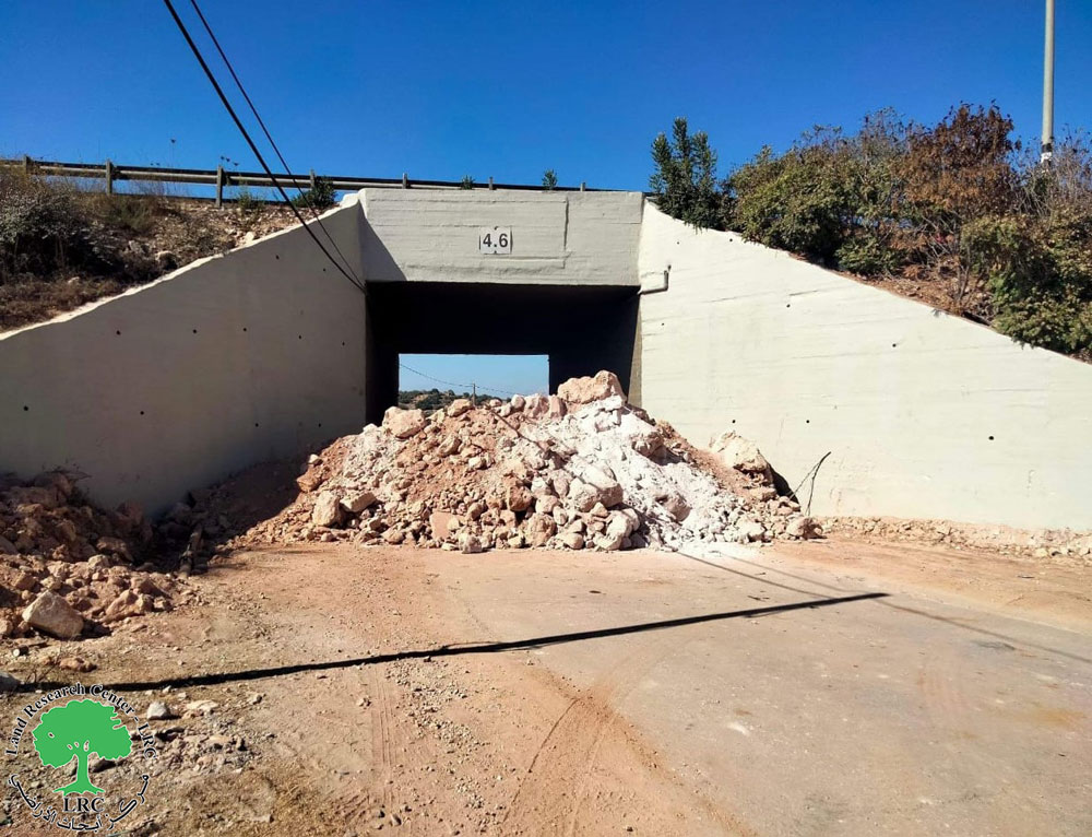
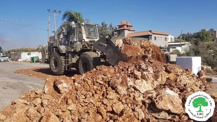
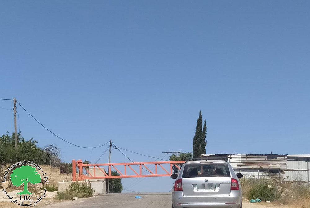
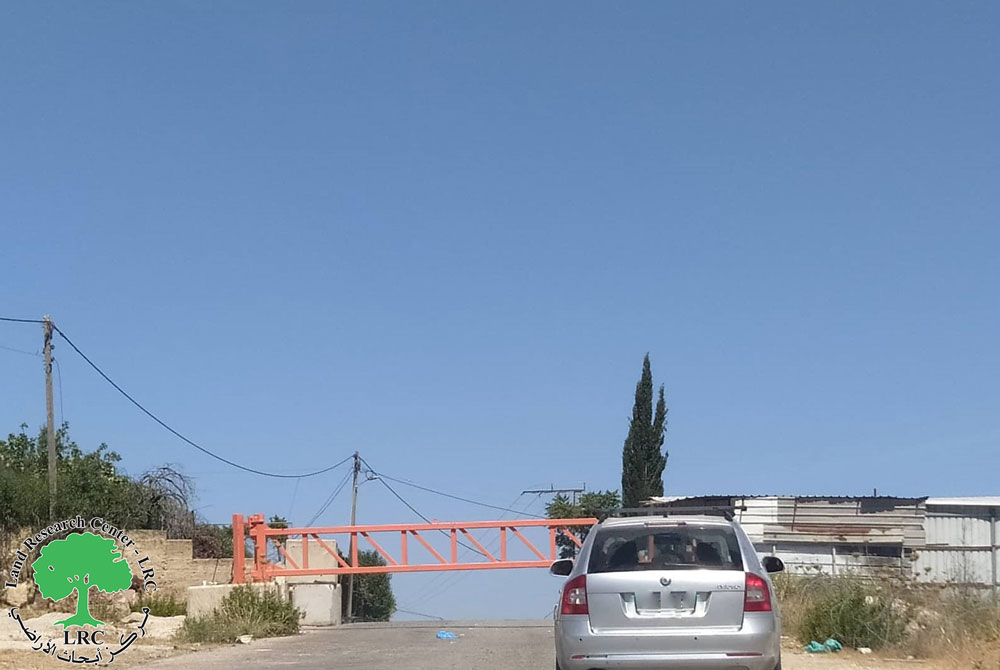
On the 18th of October, 2015, the Israeli occupation Authorities set up new cement wall blocks on lands of Jabal Al Mukkabir town in occupied East Jerusalem to separate the town from the nearby Israeli neighborhood, Armon Hanetzev, part of East Telpiot settlement, allegedly to provide protection to Israeli settlers living in the neighborhood from the ongoing “round of violence” in the city and secure them from Palestinians’ attacks as stated in the Israeli media. The construction of the wall came few days after the Israeli occupation forces and Police closed the entrances/exits of a number of towns and neighborhoods in occupied East Jerusalem in an attempt to contain the “wave of violence” in the city.
The closure imposed by the Israeli occupation authorities in the occupied city of Jerusalem came in light of the Israeli Cabinet decision announced on the 13th of October 2015, to impose closure on Palestinian towns and neighborhoods in the city of Jerusalem and set up checkpoints at towns’ entrances/exits to control the movement of Palestinians living in the city. The Israeli decision was intended to make political gains and comfort among the irritated Israeli community, in order to prove to them that the Government is acting with responsibility in response to the “Palestinian terrorism” in the city, regardless of the Israeli policy's negative impact on the Palestinian society. Accordingly, Israel set up 36 checkpoints and obstacles in the city, including large cement wall blocks and new checkpoints (in addition to the already existing one) manned by Israeli soldiers and police. See Map 1
Map 1: The newly erected checkpoints in occupied East Jerusalem
The Israeli checkpoints were set up at the entrances/exits of Al Isawiya town, At Tur, Wadi Al Joz, Jabal Al Mukkabir, Jabal Az Zaytoun (Mount of Olives), Ash Sheikh Jarrah, Al Musrara, Ath Thuri neighborhood, As Suwana neighborhood, Silwan, Ras Al Amoud, Sur Baher, Um Tuba, As Sawahra, Khallet An Nu’man, Az Zayem and Jerusalem. These checkpoints tightened the movement of more than 230 thousand Palestinians who live in the city. Additionally, the Israeli police prevented Palestinians from crossing these checkpoints without being thoroughly checked. Table 1 lists the checkpoints that were erected in occupied East Jerusalem communities along with their location:-
|
Table 1: The list of Israeli Checkpoints erected in occupied East Jerusalem city |
|
|
Location of the Checkpoint – Nearby Palestinian community |
No. of checkpoints and obstacles |
|
Al Musrara |
1 |
|
As Sawahra Al Gharbieh |
2 |
|
Ash Sheikh Jarrah Neighborhood |
3 |
|
As Suwana Neighborhood |
1 |
|
At Tur |
3 |
|
Al Isawiya Town |
4 |
|
The British High Commissioner's headquarter |
1 |
|
Um Tuba – Har Homa junction (south) |
2 |
|
(Jabal Az Zaytoun (Mount of Olives |
1 |
|
Augusta Victoria Hospital |
1 |
|
Ath Thuri (Abu Tur) |
3 |
|
Kahllet An Nu’man |
1 |
|
Ras Al Amoud Neighborhood |
5 |
|
Silwan and Wadi Hilwah |
1 |
|
Sur Baher |
1 |
|
Telpiot Settlement |
1 |
|
Nof Zion settlement |
2 |
|
Wadi Al Joz Neighborhood |
2 |
|
Wadi Ar Rababa Neighborhood |
1 |
|
Total |
36 |
|
Applied Research Institute – Jerusalem (ARIJ, 2015 |
|
Certainly, Israel has justified its decision to impose closure on Palestinian towns and neighborhoods in occupied East Jerusalem under the pretext of “protecting settlers” and "facing the dangers threatening its security in the city," and in this case, it targets the Palestinians living in the city of Jerusalem;
However, the imposed Israeli closure proved to be a mere attempt to increase the suffering of Palestinians living in the city, by restricting their movement and disturbing their day-to-day life and this is exactly what is considered as "a policy of collective punishment”, which is prohibited by the various International laws and human conventions, most specifically, article 33 of the fourth Geneva Convention relative to the Protection of Civilian Persons in Time of War, Geneva, 12 August 1949, which states that "No general penalty, pecuniary or otherwise, shall be inflicted upon the population on account of the acts of individuals for which they cannot be regarded as jointly and severally responsible".
The current Israeli closure policy has a negative and destructive impact on the educational process in the city of Jerusalem, where approximately 60,000 students were subjected to the Israeli closure policy in the city, which greatly hampered the educational process in terms of the arrival of students and teachers to their schools due to the inspections that were carried out by Israeli police/forces and intended mainly to disrupt the educational process as a whole, in addition to the traffic crisis resulting from the erection of these checkpoints and concrete blocks and the inability of school buses transporting students from getting to school on time, as well as many Palestinian students/teachers who were forced to cross the checkpoints on foot to avoid delay to school and/or to work. See Table 2
|
Table 2: Palestinian communities affected by the Israeli closure policy in occupied East Jerusalem – October 2015 |
||||
|
Name of Palestinian Community |
Community Population |
No. of Schools |
No. of students in schools affiliated to the UN, Awqaf and Private schools |
No. of Students in schools affiliated to the municipality of Jerusalem |
|
Ath Thuri |
15500 |
6 |
320 |
42271 |
|
Az Zayem |
3080 |
2 |
172 |
|
|
Al Isawiya |
15500 |
7 |
285 |
|
|
Um Tuba |
Included in Surbaher population |
2 |
482 |
|
|
Jerusalem (Ash Sheikh Jarrah, Wadi Al Joz, As Suwana , At Tur, Ash Shayyah, Ras Al Amoud, Bab As Sahera, and Jerusalem city) |
113200 |
69 |
13306 |
|
|
Jabal Al Mukkabir |
21127 |
8 |
326 |
|
|
Silwan |
23500 |
3 |
63 |
|
|
Sur Baher and Um Tuba |
21500 |
14 |
2751 |
|
|
As Sawahra Al Gharbieh |
18500 |
2 |
— |
|
|
Total |
231907 |
113 |
17705 |
|
|
Grand Total |
|
59976 |
||
|
Source (1): The Applied Research Institute – Jerusalem (ARIJ), 2015 |
||||
|
Source (2): Information Technology and Education |
||||
It should be noted that during the past two months, September and October of 2015, a wide range of clashes have broken out in the occupied city of Jerusalem between the occupation forces and Palestinians on one hand, and the settlers and Palestinians on the other, in light of the repeated incursions to the courtyards of Al-Aqsa Mosque in Jerusalem which was carried out by settlers during the Jewish holidays.
Accordingly, the Israeli authorities announced tight security measures in the city and increased restrictions on the entry of Palestinian worshipers to Al-Aqsa Mosque and allowed only Palestinians over forty years old (men and women alike) to enter the mosque, and abused Palestinians who took upon themselves to protect Al-Aqsa Mosque from the settlers’ repeated incursions.
Additionally, the Israeli occupation police vandalized the holy mosque and fired Tear Gas Bombs at Palestinian worshippers. Also hundreds of Israeli police intensified in and around Al-Aqsa mosque and through the narrow streets and alleys of the Old City of Jerusalem, especially those leading to the gates of Al-Aqsa Mosque. The Israeli Occupation Authorities have also blocked roads and entrances of Palestinian towns in the occupied city of Jerusalem and placed checkpoint and cement blocks in order to control the movement of Palestinians heading to pray in Al Aqsa Mosque.
The repeated incursions to Al Aqsa Mosque by the Israeli settlers’ groups fueled the conflict in the holy city of Jerusalem in particular and in the rest of the occupied West Bank in general. During the last two months and till the date of this report, (18th of October of 2015), the Applied Research Institute-Jerusalem (ARIJ) recorded more than 260 assaults committed by Israeli settlers in the various West Bank governorates, and varied between storming of Al-Aqsa Mosque and attacking and beating Palestinian civilians, running over people, harassments, shootings and attacking property.
It should be noted that Israel is putting convoluted efforts to reflect the image of what is happening in the occupied Palestinian territory to the international community, by casting the blame on the Palestinian National Authority for the continued violence in the area, and pointing the finger at the Palestinian President Mahmoud Abbas in particular of leading “the dangerous incitement" with his "hate-filled speech" which he gave on the 16th of October 2015 as stated by the new Israeli ambassador to the United Nations, Danny Danon, during the speech he gave at the UN Security Council on the 22nd of October 2015. Danon also “urged the Security Council to break its silence and make a statement against "the incitement that fuels terror" (targeting Abbas) and support direct negotiations between Israel and the Palestinians.”[1]
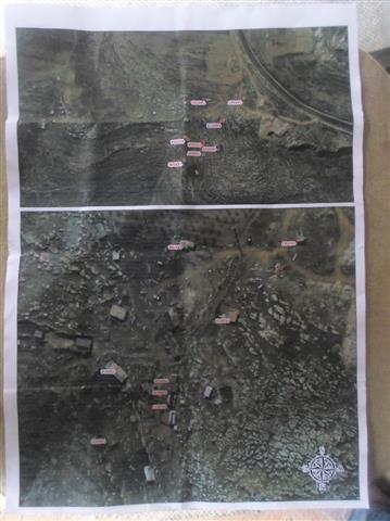
However, the repeated and systematic incursions upon Al-Aqsa Mosque especially during the first weeks of September 2015, fueled the spark of violence in the holy city and the rest of West Bank Governorates, which prompted Palestinians to defend the holy site, due to its religious and historic importance. Also, Israel is trying to change the status quo of the Temple mount which houses Al Aqsa Mosque in view of the current security situation; The plan of Beit Haliba is yet the latest example of Israel’s plans seeking to change the current status of the city. The plan was revealed by the Israeli daily newspaper, Yedioth Ahronoth in August 2015, and aims at Judaizing Al-Aqsa Mosque and its surroundings. The plan includes the building of a three-storey facility that will include classrooms and auditorium intended to teach visitors about the history of the so called “Western Wall” in addition to a library, a learning center, a guide room. On top of the building there will be an observation deck that will be accessible by Israelis from the Jewish Quarter in the old city of Jerusalem. See Map of Beit Haliba Plan
Photo 2: The plan of Beit Haliba near Al Aqsa Mosque in Jerusalem city.
Case Study: Al Isawiya town severely affected by the Israeli closure policy.
The Israeli closure policy imposed on Palestinians living in the occupied city of Jerusalem is a collective punishment that has caused a paralysis in all sectors in the city, including commerce, tourism, health and education, in addition to controlling the movement of thousands of Palestinians in the city. All this practically has increased the suffering of the Palestinians in the city, and most specifically, the town of Issawiya, where the Israeli occupation forces erected four checkpoints and cement blocks at the town’s entrances/exits from both, its eastern and western sides.
The closure imposed on Al Isawiya town affected the daily life of thousands of Palestinians living there (more than 15,000) as soldiers manning the checkpoints stopped Palestinian vehicles, checked passengers’ identity cards, causing a traffic jam and this all was done allegedly for providing security and protection to Israeli settlers living in the illegal Israeli settlements nearby.
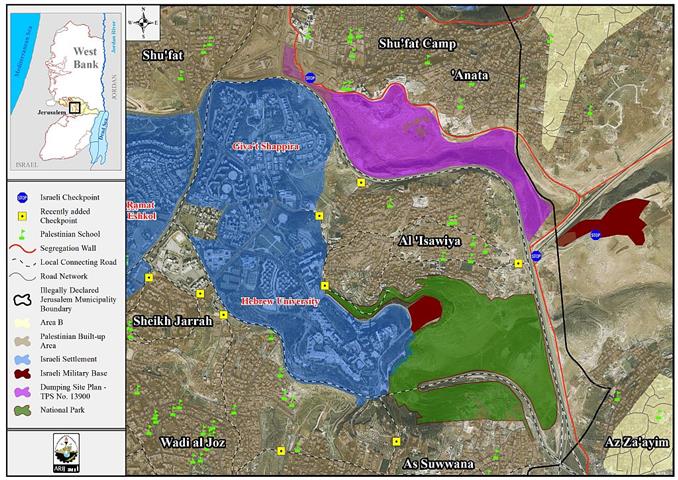
The Israeli occupation authorities erected a checkpoint at the eastern entrance of Al Issawiya town which connects it with Anata town and Shu’fat refugee camp in the north, on one hand, and Az Ayyem, As Suwana neighborhood and a number of Palestinian towns and neighborhoods in the south, on the other. The Israeli forces also closed three other entrances/exits of Al Isawiya town from the west, near Givat Shapira Settlements (the French Hill) and the Hebrew University and prevented Palestinians from crossing. See Map 2
Map 2: Israeli checkpoints erected in and around Al Isawiya town.
Due to its strategic location to the north-east of Jerusalem city, Al Isawiya town has been subjected to numerous Israeli confiscations for the benefit of various Israeli targets. These Israeli aims are represented in the construction of Israeli settlements, outposts, military bases and checkpoints and bypass roads on the town’s lands and its surroundings, in addition to the Israeli segregation plan. The following is a breakdown of Israeli confiscations of Al Isawiya town lands:
During the Israeli Occupation of the Palestinian territory, the Israeli authorities confiscated more than 1,000 dunums in Al Isawiya town to establish four Israeli settlements on the town’s land and the surrounding Palestinian communities, they are: “Hebrew University”, “Giv’at Shappira”, “Ma’ale Adummim” and “Mishr Adummim” settlements. The four settlements are currently inhabited by approximately 58,000 Israeli settlers.
Moreover, El ‘Isawiya town has lost more lands during the Israeli occupation represented in the construction of two military bases on the town’s territory. One is located adjacent to the town from its southern side near “Hebrew University” settlement, whilst the other is located on extended lands to the east near “Mishr Adummim” settlement. The area confiscated for the two military bases is estimated at 616 dunums and has been established by the Israeli Occupation under the pretext of protecting settlements in the area.
In August 2013, the Israeli occupation bulldozers flattened 20 dunums of land in At Tur and Al Isawiya towns, in east Jerusalem for the establishment of a national park on lands of the two aforementioned communities. Note that on April 4, 2011, the “District Planning and Building Committee” of the Israeli Ministry of Interior approved a Town Plan Scheme No. 11092A to turn 662 dunums of lands from Al Isawiya and At Tur communities’ lands into a National Park. The objective of the Plan is (1) to connect the area with the "Holy Basin, (2), to eliminate Palestinian urban development: offering no housing plan in response to the needs of the growing Palestinian population in the future, (3) the 2020 Jerusalem Master Plan: “the city's population must have a Jewish majority and Palestinian minority”, (4) the plan marks the eastern Gate of Jerusalem, (5) the "National Park" will connect the Hebrew University settlement in the west of Jerusalem city with the main road leading to Ma'ale Adumim Settlement in the east and At-Tur neighborhood (Mount of Olives in the south to Al 'Isawiya in the north.), and (6) the National park Plan No. 11092 is a small part of a large-scale Israeli National Parks Plan to construct nine national parks in the hills of Jerusalem and around the municipal borders.
Another plan to capture more Palestinian land from Al Isawiya town was revealed on March 23, 2013 and approved by the Israeli Municipality of Jerusalem on the 16th of February 2015, is the plan No. (13900), which states the confiscation of 543 dunums of Palestinian owned land of ‘Anata and Al Isawiya and Shu’fat Refugee Camp for the use of a “landfill”, to dump Israeli solid and building waste for the next 20 years and then to be rehabilitated as a National Park for sole Jewish use …….on an expropriated Palestinian lands within 1967 borders!!! Once implemented, the “landfill” will leave no space for Shu´fat refugee Camp, neither A´nata nor Al Isawiyya to expand. Furthermore the plan will require the displacement of approximately 120 Bedouin residents.
Moreover the proposed site dovetails, physically, with the E-1 Plan and the Mount Scopus Slopes National Park Scheme. The cumulative impact of these plans is the creation of a coherent, contiguous physical link between Maale Adumim settlement bloc and Jerusalem, and the isolation of the Palestinian populated areas nearby.
Al ‘Isawiya Town and the Israeli Segregation Wall plan
The construction of the Israeli Segregation Wall has a negative impact on Al Isawiya town. According to the last amendment of the Israeli segregation wall route, which was published on the webpage of the Israeli Defense Ministry on 30th April 2007, the Segregation Wall divides the town’s lands into two parts. The first part totally isolates the built-up area of Al Isawiya town within the Jerusalem Municipal boundaries, away from West Bank lands and the town’s lands in the east. The Segregation Wall also isolates this part of the town from the adjacent towns of Anata and Az Zayyem which both have historical and social relations with Al Isawiya. The area inside Jerusalem isolated by the Segregation Wall is approximately 2,550 dunums (27.1% of the town’s total area). The other part of Al Isawiya is facing the danger of confiscation by the segregation plan of “Greater Jerusalem[2]” which includes the annexation of “Ma’ale Adumim” bloc and its surrounding areas. Upon the implementation of this future plan, all of Al Isawiya lands extended to the east, which constitute 72% of the town’s total area (6828 dunums) will be confiscated and isolated.
The Israeli Closure Policy in International Law
The Israeli closure policy imposed in the city of Jerusalem and the denial of Palestinians freedom of movement within the city itself, and the rest of the occupied West Bank comes in violation of the third article of the Universal Declaration of Human Rights, which was adopted by the UN General Assembly on the 10th of December 1948 and which states that “Everyone has the right to life, liberty and security of person.”
The Freedom of Movement is protected by Article 12 of the International Covenant on Civil and Political Rights (ICCPR) which states: ''Everyone lawfully within the territory of a State shall, within that territory, have the right to liberty of movement and freedom to choose his residence.'
In the OPT, other rights are contingent upon freedom of movement and also protected in their own right. For instance, the right of access to healthcare is protected by Article 12 of the International Covenant on Economic, Social and Cultural Rights (ICESCR); the right to education is protected under Article 12 of the ICESCR and Article 26 of the Universal Declaration of Human Rights (UDHR); the right to freedom of religion is protected under Article 18 of the ICCPR; the right to work is protected under Article 6 of the ICESCR; the right to food and water is protected under Article 11 of the ICESCR and Article 26 of the UDHR; and other rights also fall under various aspects of human rights law. Israel's checkpoints, however, seriously impede, hinder and often explicitly prevent the implementation of these rights and the provisions of the international human rights laws which protect them.
[1] Danon to UN: Stop excuses for the Palestinians
http://www.jpost.com/Israel-News/Politics-And-Diplomacy/Danon-to-UNSC-Stop-making-excuses-for-the-Palestinians-429817
[2] The "Greater Jerusalem" includes the annexation of the major settlement blocs surrounding Jerusalem city to Israel. This step aims at re-delineation of Jerusalem City borders to commensurate with the Israeli plans that tends to change the demographic status in the City for the benefit of the Israelis, and to exclude neighborhoods of high Palestinian population density from Jerusalem City. The Israeli settlement blocs are: Ma'ale Adummim Israeli settlement bloc in the east, Giv'at Ze'ev settlement bloc in the north and Gush Etzion settlement bloc in the south.
Prepared by:
The Applied Research Institute – Jerusalem


