• About The Project
  • Palestine in Century
  • Selected Maps
  • Glossary
  • About ARIJ
  • About LRC
  • By Year
    • Case Studies By Year
    • Daily Report By Year
Thursday, May 22, 2025
POICA
No Result
View All Result
  • Home
  • Settlements
    • New Israeli Settlements
    • Settlement Expansion
  • Israeli Violations
    • Agriculture
    • Confiscation
    • Demolition
    • Environment
    • Eviction of Palestinians
    • Settlers Attacks
  • Bypass Roads
  • Israeli Plans
  • Segregation
    • Checkpoints
    • Closure
    • Separation Plans
  • Military Orders
  • Reports
    • Daily Report
    • Monthly Report
    • Quarterly Report
No Result
View All Result
POICA
No Result
View All Result

“Another tool to annex more Palestinian Lands” Military Extending Order to confine +400,000 dunums as “Closed Military Area”

February 14, 2015
in Military Orders
“Another tool to annex more Palestinian Lands” 
Military Extending Order to confine +400,000 dunums as “Closed Military Area”


On the 18th of January 2015, the Israeli Occupation Authorities issued the military order “ S/1/99 (Amendment border No.6) (5885 -2015) (Firing Zone No. 912)”, extending the expropriation of 410,672 dunums of lands as “Closed Military Zone”, while another 212 dunums deducted from the order since it became part of the illegal settlement of Ma’aleh Adumim.

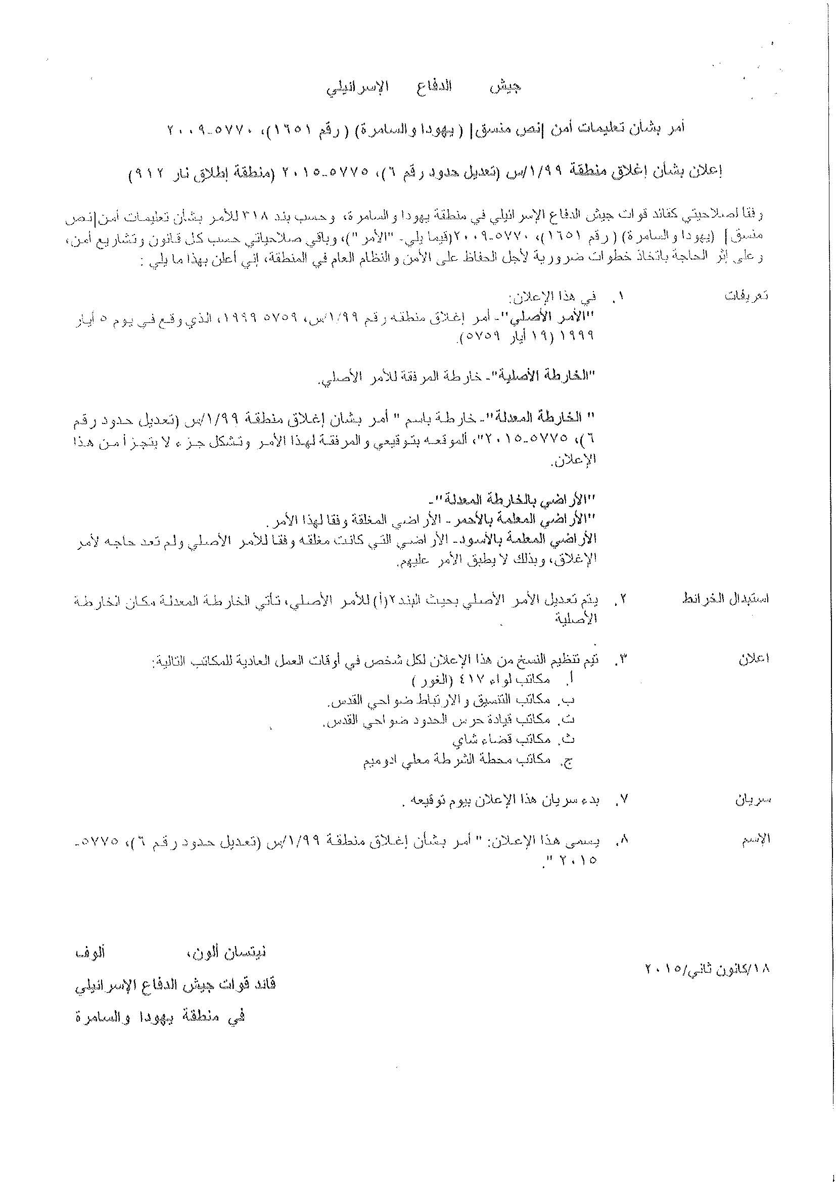
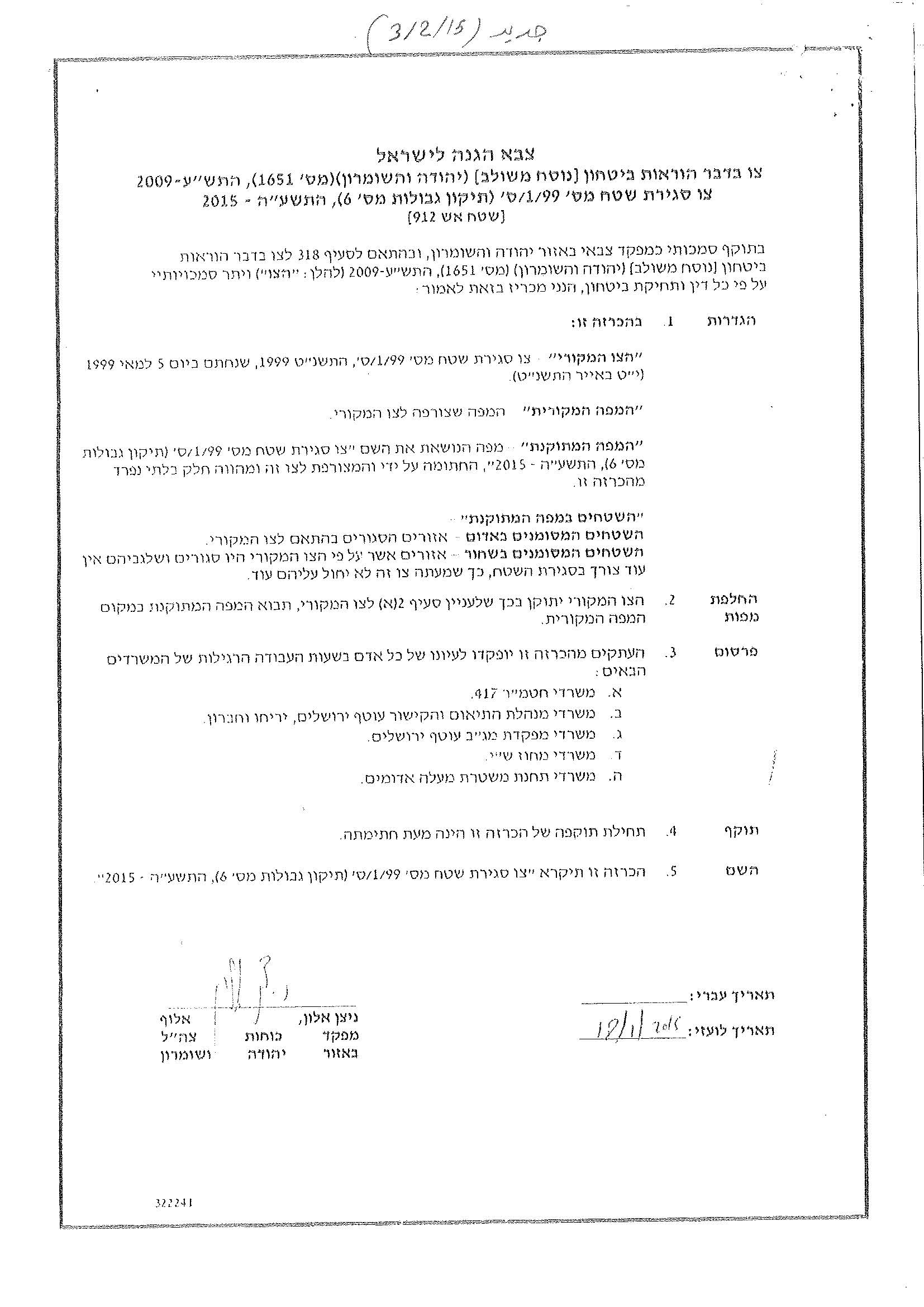
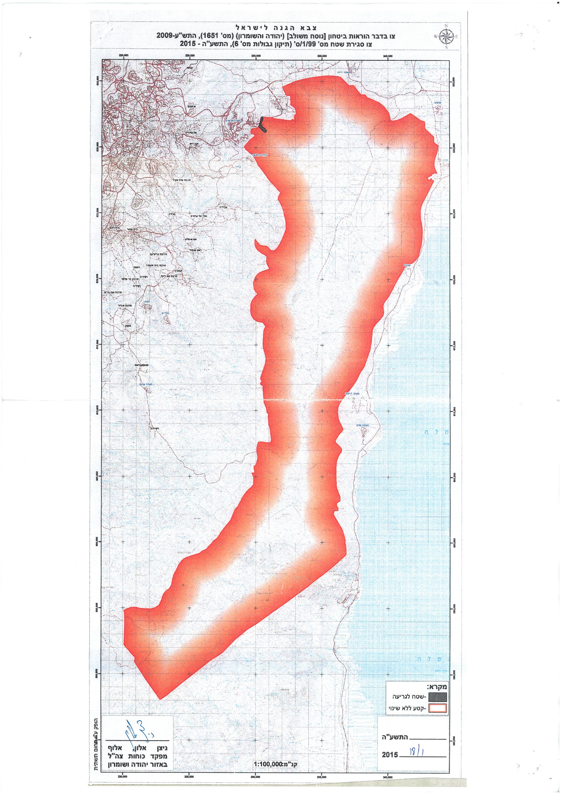
Military order “ S/1/99 (Amendment border No.6) (5885 -2015) (Firing Zone No. 912)”

According to the military order, which signed by Nitssan Allon, the commander of the Israeli Occupation Forces in the West Bank, the lands confiscated for security pretexts.

It’s worth pointed that on  the 5th of May 1999, the Israeli Authorities issued the military order No. S/1/99 (5785-1999) which targeted the same aforementioned areas (410,884 dunums, including the 212 dunums) and declared it “Closed military area”.

However, the area (212 dunums) which removed from the Firing zone area, is located east of Ma’ale Adumim settlement and part of it located within the border of the settlement.

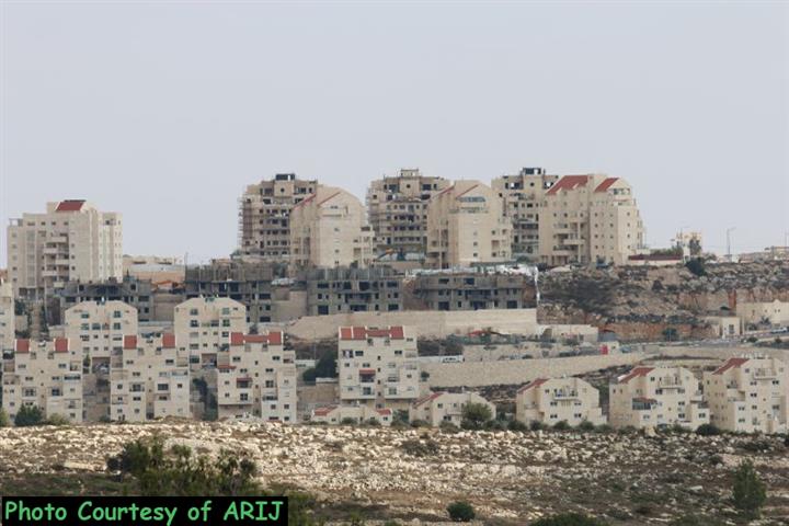
The Israeli Authorities looking forward  to expand Ma’ale Adumim settlement from the east. Also, the area that removed from the declaration of Closed Military area is already used by the Israeli settlers in Ma’ale Adumim settlement, where they build a “sport center”, which included playgrounds, gym, etc. Furthermore, they also, start to construct a road in the area, which seemingly that they planning to  construct a new colonial neighborhood to be a part of Ma’ale Adumim settlement.

In a geopolitical analysis conducted by the GIS Department at ARIJ, the area targeted by the military extending order located at the eastern part of the West Bank, started from the southern part of Jericho governorate, to  the east of Jerusalem city, then the areas at the east of Bethlehem governorate to reach to the eastern part of Hebron governorate.

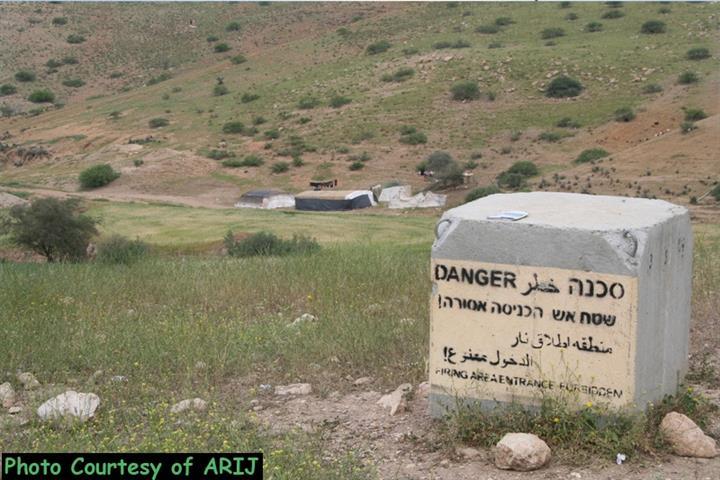
The “closed military area” or the Firing Zone No. 912 ( 410,672  dunums), located at the eastern part of West Bank, is border by the natural reserve area (166,538 dunums) from the west and from the east an area (around 140,000 dunums) confiscated by the Israeli Authorities in 2009, which added to the Israeli  settlement of Ma’ale Adumim.

Therefore an entire area of 717,210 dunums (12.6 % from the total area of the West Bank) captured by Israel under security and military purposes and nature reserve areas, where the Palestinians denied their right to reach to their lands in the targeted area.  See the map below:

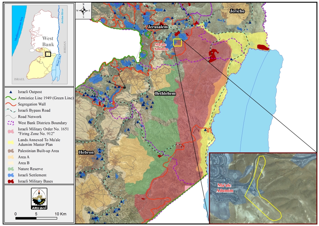
Map for the expropriated lands including the natural reserve area


Obviously, the Israeli Occupation Authorities intentionally capturing the natural reserve lands and firing zone areas in addition to close military areas, just after the year 1967 for colonial and expansionist desires.

The systematic Israeli “security & military purposes” expropriation are no more than an Israeli quirky ways to confiscate the Palestinian lands for the interest of building and expanding the illegal settlements.

Actually , the expropriation orders as “Closed military area” showing how the Israeli Authorities confiscated Palestinian land in the West Bank under several claims; security needs, state lands, closed military areas and Firing zone, and then they  transfer these land to the interest of building and expanding the illegal settlements and their outposts in all parts of the oPt.


Closed Military Areas:

Following the  Israeli military occupation of the Palestinian Territory in the year 1967, Israeli started building the illegal settlements in all parts of the West Bank while preventing the Palestinian residents from reaching , cultivating and developing over their lands mainly for the claim of “closed military area”.

It’s worth mentioning that 999,185 dunums in the West Bank (which constitute 17.6% from the total W.B area) classified as closed military areas and firing zones.

For more information about “State land and firing zone” follow this link:  https://poica.org/details.php?Article=7318.  


Prepared by:  
The Applied Research Institute – Jerusalem

Recommended For You

الأراضي الفلسطينية بين الذرائع الأمنية والأطماع الاستيطانية – “الأمن، الآثار، والطبيعة كحجج لاقتلاع الفلسطينيين من أراضيهم”

by arij
April 15, 2025
0

مقدمة شهدت الأراضي الفلسطينية في الضفة الغربية المحتلة على مدار عقود طويلة سياسة ممنهجة من المصادرة الإسرائيلية للأراضي، حيث تبرر سلطات الاحتلال الإسرائيلي هذه السياسة بمجموعة من الذرائع...

Read moreDetails

سلطات الاحتلال الإسرائيلي تخصص ما يزيد عن 16,000 دونما من الأراضي الفلسطينية التي تحيط بالمستوطنات الإسرائيلية لأغراض الرعي

by arij
February 12, 2025
0
سلطات الاحتلال الإسرائيلي تخصص ما يزيد عن 16,000 دونما من الأراضي الفلسطينية التي تحيط بالمستوطنات الإسرائيلية لأغراض الرعي

  أصدرت سلطات الاحتلال الإسرائيلي في العاشر من شهر شباط من العام 2025 ستة أوامر عسكرية جديدة تقضي"بإعلان عن نية المسؤول عن الأملاك الحكومية وأملاك الغائبين على المصادقة...

Read moreDetails

Sheep Pens in Bardala Village Falls to a systematic Attack of the Israeli Army, Aiming to Displace the Community

by arij
January 30, 2025
0
اخطارات اسرائيلية بوقف العمل في قرية بردلة

The Israeli Settlement Council Organization stormed the village of Bardala, northeast of Tubas, targeting a sheep pen owned by Mr. Louay Abu Rushdi. The escorting occupation Army issued...

Read moreDetails

اخطارات اسرائيلية بوقف العمل في قرية بردلة

by arij
January 30, 2025
0
اخطارات اسرائيلية بوقف العمل في قرية بردلة

  الموقع: بردلة -الأغوار الشمالية / محافظة طوباس الجهة المعتدية: المجلس الأعلى للتخطيط /تنظيم مجلس المستوطنات الجهة المتضررة: السيد لؤي ابو رشدي الانتهاك: وقف عمل لحظيرة أغنام تفاصيل...

Read moreDetails

إخطارات بهدم بركسات سكنية وزراعية في تجمع عاطوف

by arij
January 23, 2025
0
Demolition Notices for Residential and Agricultural Structures in the Atouf Community

  الانتهاك: إخطارات بهدم مسكن وحظائر اغنام الموقع: الرأس الاحمر- عاطوف / محافظة طوباس الجهة المعتدية: تنظيم مجلس المستوطنات الجهة المتضررة: السيد ثائر حسين تفاصيل الانتهاك أقدمت قوات...

Read moreDetails
Next Post
“صفقة اراضي” جديدة لصالح البناء الاستيطاني في الاراضي الفلسطينية المحتلة”

"صفقة اراضي" جديدة لصالح البناء الاستيطاني في الاراضي الفلسطينية المحتلة"

LATEST NEWS

Expansion of Gilo Settlement: A Strategic Plan to Isolate Bethlehem and Undermine Palestinian Rights

Expansion of Gilo Settlement: A Strategic Plan to Isolate Bethlehem and Undermine Palestinian Rights

by arij
May 12, 2025
0

........................................................

الأراضي الفلسطينية بين الذرائع الأمنية والأطماع الاستيطانية – “الأمن، الآثار، والطبيعة كحجج لاقتلاع الفلسطينيين من أراضيهم”

by arij
April 15, 2025
0

........................................................

الطرق الالتفافية الاسرائيلية وأثرها على البيئة الفلسطينية

انتهاك للطبيعة والهوية في الأراضي الفلسطينية المحتلة

by arij
March 17, 2025
0

........................................................

Israel Advances Settlement Plan on Ancient Olive Groves on lands of Beit Jala city, Violating International Law and depriving Palestinians their lands

إسرائيل تمضي قدمًا في مخطط استيطاني جديد على أراضي مدينة بيت جالا، في انتهاك للقانون الدولي وحرمان الفلسطينيين من أراضيهم

by arij
April 29, 2025
0

........................................................

flag_yellow_lowEU-PfP-Logo

This website has been produced with the assistance of the European Union. The contents of this publication are the sole responsibility of ARIJ & LRC and can in no way be taken to reflect the views of the European Union.

© 2025 Copyright ARIJ . All Rights reserved. .

No Result
View All Result
  • Home
  • Settlements
    • New Israeli Settlements
    • Settlement Expansion
  • Israeli Violations
    • Agriculture
    • Confiscation
    • Demolition
    • Environment
    • Eviction of Palestinians
    • Settlers Attacks
  • Bypass Roads
  • Israeli Plans
  • Segregation
    • Checkpoints
    • Closure
    • Separation Plans
  • Military Orders
  • Reports
    • Daily Report
    • Monthly Report
    • Quarterly Report

© 2025 Copyright ARIJ . All Rights reserved. .