• About The Project
  • Palestine in Century
  • Selected Maps
  • Glossary
  • About ARIJ
  • About LRC
  • By Year
    • Case Studies By Year
    • Daily Report By Year
Thursday, March 5, 2026
POICA
No Result
View All Result
  • Home
  • Settlements
    • New Israeli Settlements
    • Settlement Expansion
  • Israeli Violations
    • Agriculture
    • Confiscation
    • Demolition
    • Environment
    • Eviction of Palestinians
    • Settlers Attacks
  • Bypass Roads
  • Israeli Plans
  • Segregation
    • Checkpoints
    • Closure
    • Separation Plans
  • Military Orders
  • Reports
    • Daily Report
    • Monthly Report
    • Quarterly Report
No Result
View All Result
POICA
No Result
View All Result

A new Israeli military order allows the confiscation of Palestinian land in Sair Town

September 4, 2014
in Military Orders
A new Israeli military order allows the confiscation of Palestinian land in Sair Town


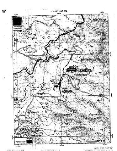
On the 25th of August 2014, the Israeli occupation Army issued a new military order number 14/21/T to residents of Sa’ir town in Hebron Governorates to seize 10.716 dunums of Palestinian land for imperative security purposes. Residents of the aforementioned community were given a period of 45 days from the date the order was issued to file their objections against the seizure order at the District Coordination Offices (DCO) in Gush Etzion in Bethlehem Governorate. The area targeted in the military order is located in Basin no.2 in Al Kanub and Kinan Al Lusela sites in Sa’ir town.

Only on August 31st 2014 that residents of the aforementioned Palestinian community received the seizure order, 7 days after the order was issued. See Photos 1-3


Photos 1, 2 & 3: copies of the military order No. 14/21/T. in Hebrew and the attached maps.


Analysis conducted by the Geo-Informatics department at the Applied Research Institute – Jerusalem (ARIJ) of the military order and the attached maps showed that the targeted land (the 10 dunums) is located to the north of Asfar (Metzad) settlement  which was established on Sa’ir town land back in 1983, and parallel to the Israeli bypass road No. 3670 which links Asfar settlement with the nearby Israeli outpost “Pnei Kedem”.  The analysis also showed that the targeted land is already occupied either by settlers themselves or by the Israeli Occupation Army and includes a number of mobile homes in addition to one big barracks in the site.  

It is likely that the process of confiscating the land, which comes for security reasons, according to what is stated in the Israeli military order, will be to transform the use of the existing facilities by the Israeli occupation army in favor of establishing a permanent Israeli military camp in that area. See Map 1

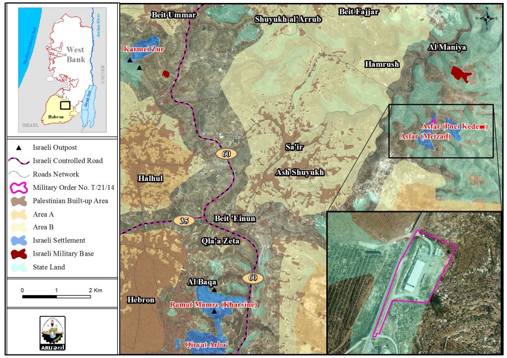
Map 1: the target land in the militray order No. 14/21/T


Note that the targeted land as delineated in the military order was illegally declared “State Land" following Israel’s occupation of the West Bank, including East Jerusalem and the Gaza Strip in 1967. Accordingly, Israel claims that the land is "originally" the property of the state of Israel and only the State is entitled to use the land as it sees best; and therefore, the military order No. 14/21/t  which states the seizure of 10 dunums of land of Sa’ir, comes as a request from the Israeli occupation army to use the land from its “owner”, the "State of Israel" itself, as claimed.

Furthermore, it is likely that the State of Israel would not object the use of this land by the Israeli Occupation army as the security concern constitutes a very strategic importance to the "State of Israel", and the majority of land confiscations are fulfilled for these reasons, as well as the process of building the Israeli Segregation wall on the Palestinian territory which was also built for security reasons.

Since the targeted land is previously used, the process of turning it into a military camp will not take a lot of time and procedure, and the process of issuing an order to seize the land, is “purely” a legal one according to Israel, to legitimize the use of the land by the Israeli occupation army.  

To conclude,

By forcing facts on the ground and manipulating the geographic and demographic balance of the occupied Palestinian territory, Israel is destroying any possibility of fruitful negotiations with the Palestinians to reach a peace agreement based on a two-state solution. This continuous expansion and development of Israeli settlements and other military structures cannot be interpreted as a good faith effort by Israel to resume serious peace negotiations with the Palestinians when the Israeli authorities keep issuing plans for building in settlements and military orders to seize land. This in turn, will increase the fragmentation of the West Bank territory and will endanger the possibility of a contiguous Palestinian state in the future.

. 

Prepared by:  
The Applied Research Institute – Jerusalem

Recommended For You

سلطات الاحتلال الإسرائيلي تستخدم الأوامر العسكرية لتعمق المشروع الاستيطاني في الضفة الغربية المحتلة

by arij
February 26, 2026
0
سلطات الاحتلال الإسرائيلي تستخدم الأوامر العسكرية لتعمق المشروع الاستيطاني في الضفة الغربية المحتلة

تقديم منذ احتلال الضفة الغربية عام 1967، اعتمدت سلطات الاحتلال الإسرائيلي منهجية واسعة عبر استخدام الأوامر العسكرية كأداة "قانونية" لفرض الوقائع الجغرافية والديموغرافية على الأرض الفلسطينية. وأصبحت هذه...

Read moreDetails

بين مطرقة الأوامر العسكرية وسندان التقييد الجغرافي, أوامر عسكرية إسرائيلية جديدة تطال أكثر من 1000 دونم في طوباس

by arij
November 26, 2025
0
بين مطرقة الأوامر العسكرية وسندان التقييد الجغرافي, أوامر عسكرية إسرائيلية جديدة تطال أكثر من 1000 دونم في طوباس

في الحادي والعشرين من شهر تشرين الأول لعام 2025، تسلّم أهالي محافظة طوباس سلسلة من الأوامر العسكرية الإسرائيلية التي استهدفت مساحات واسعة من الأراضي الفلسطينية في المحافظة. وقد...

Read moreDetails

“ما يزيد عن 25 ألف دونم من أراض الزيتون”,
موسم الزيتون في فلسطين تحت رهن الأوامر العسكرية

by arij
March 4, 2026
0

نشرت سلطات الاحتلال الإسرائيلي في الثاني والعشرين من شهر تشرين أول من العام 2025 مجموعة من الأوامر العسكرية والتي استهدفت مساحات شاسعة من الأراضي الفلسطينية في محافظات الضفة...

Read moreDetails

ما يزيد عن 1900 دونما من الأراضي الفلسطينية في بيت لحم مهددة بالعزل لصالح مستوطنة افراتا

by arij
October 8, 2025
0
ما يزيد عن 1900 دونما من الأراضي الفلسطينية في بيت لحم مهددة بالعزل لصالح مستوطنة افراتا

في الثاني من شهر تشرين أول من العام 2025، أصدرت سلطات الاحتلال الإسرائيلي أمرًا عسكريًا جديدًا يحمل الرقم (ت/3/25) تحت عنوان "تعديل حدود – يهودا والسامرة، 5785-2025". ويأتي...

Read moreDetails

سلطات الاحتلال الإسرائيلي تستغل ‘المنفعة العامة’ لنهب الموارد الفلسطينية

by arij
September 30, 2025
0
سلطات الاحتلال الإسرائيلي تستغل ‘المنفعة العامة’ لنهب الموارد الفلسطينية

في الاول من شهر ايلول من العام 2025، نشرت الإدارة المدنية الإسرائيلية، الذراع الأيمن لحكومة الاحتلال الإسرائيلي أمرا عسكريا جديدا تحت عنوان " أمر ءبشأن قانون الأراضي (الاستملاك...

Read moreDetails
Next Post
A new colonial quarter in the outpost of Har Bracha in Nablus

A new colonial quarter in the outpost of Har Bracha in Nablus

LATEST NEWS

سلطات الاحتلال الإسرائيلي تستخدم الأوامر العسكرية لتعمق المشروع الاستيطاني في الضفة الغربية المحتلة

سلطات الاحتلال الإسرائيلي تستخدم الأوامر العسكرية لتعمق المشروع الاستيطاني في الضفة الغربية المحتلة

by arij
February 26, 2026
0

........................................................

تسجيل الأراضي أم الضم عبر السجل؟ الرهانات القانونية والسياسية لتسوية الملكيات في الضفة الغربية

تسجيل الأراضي أم الضم عبر السجل؟ الرهانات القانونية والسياسية لتسوية الملكيات في الضفة الغربية

by arij
February 26, 2026
0

........................................................

حين تتقلص الخريطة: تسارع غير مسبوق في توسّع المستوطنات الإسرائيلية خلال عام 2025

حين تتقلص الخريطة: تسارع غير مسبوق في توسّع المستوطنات الإسرائيلية خلال عام 2025

by arij
February 16, 2026
0

........................................................

الضفة الغربية بين إرهاب المستوطنين وتواطؤ الاحتلال – حصيلة العام 2025

الضفة الغربية بين إرهاب المستوطنين وتواطؤ الاحتلال – حصيلة العام 2025

by arij
February 16, 2026
0

........................................................

flag_yellow_lowEU-PfP-Logo

This website and its content were initiated in 1993 by the Applied Research Institute – Jerusalem (ARIJ) and the Land Research Center (LRC) with the support from the European Union up until 2023. Since then, the Applied Research Institute – Jerusalem (ARIJ) has taken over the continued development and maintenance of the website. The views expressed remain solely those of ARIJ) and do not necessarily reflect those of the European Union.

© 2026 Copyright | ARIJ | All Rights reserved.

No Result
View All Result
  • Home
  • Settlements
    • New Israeli Settlements
    • Settlement Expansion
  • Israeli Violations
    • Agriculture
    • Confiscation
    • Demolition
    • Environment
    • Eviction of Palestinians
    • Settlers Attacks
  • Bypass Roads
  • Israeli Plans
  • Segregation
    • Checkpoints
    • Closure
    • Separation Plans
  • Military Orders
  • Reports
    • Daily Report
    • Monthly Report
    • Quarterly Report

© 2026 Copyright | ARIJ | All Rights reserved.