• About The Project
  • Palestine in Century
  • Selected Maps
  • Glossary
  • About ARIJ
  • About LRC
  • By Year
    • Case Studies By Year
    • Daily Report By Year
Friday, October 3, 2025
POICA
No Result
View All Result
  • Home
  • Settlements
    • New Israeli Settlements
    • Settlement Expansion
  • Israeli Violations
    • Agriculture
    • Confiscation
    • Demolition
    • Environment
    • Eviction of Palestinians
    • Settlers Attacks
  • Bypass Roads
  • Israeli Plans
  • Segregation
    • Checkpoints
    • Closure
    • Separation Plans
  • Military Orders
  • Reports
    • Daily Report
    • Monthly Report
    • Quarterly Report
No Result
View All Result
POICA
No Result
View All Result

The Israeli army shuts down a number of Aqraba agricultural lands

July 9, 2014
in Closure
The Israeli army shuts down a number of Aqraba agricultural lands


Violation: the occupation army shuts down a number of Aqraba agricultural lands

Date: July 09, 2014

Location: Aqraba town

Perpetrators: the occupation military

Details:

In the evening of Wednesday, a massive force of the occupation accompanied by a military bulldozer closed two agricultural lands in Aqraba town by dirt walls.

It should be marked that the two roads are located in the southern part of the town and considered the linking point with the surrounding towns and the agricultural lands aligning with the road no.5 that leads  to the Jordan Valley (al ghoor).

It should be also mentioned that the recent closure  came after  the re-opening of the roads  that were closed  for a period of twelve years. In the aftermath of the second Intifada, the Israeli occupation imposed closure on main and sub roads in addition to agricultural roads. Aqraba town had been badly impacted since several parts of its lands remained closed until the beginning of2014.

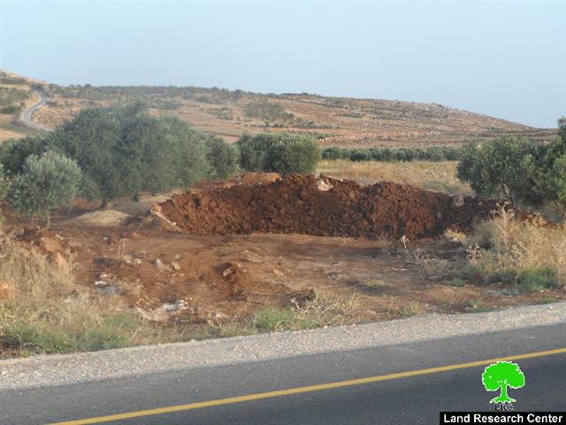
According to the LRC field follow-up :" the town has two closed roads: the first is 2km in length that served a number of agricultural lands and is considered the town's main entrance, the second is 1km in length and served vast area of lands planted with olive".

Photo1: the first closed road

Photo 2: the second closed agricultural road


About Aqraba:

18 kilometers to the southwest of Nablus, Aqraba can be set as an example of a recurrent target for the Israeli occupation attacks.

The village total area is 34,660 dunums, mostly, agricultural lands. However, the Israeli occupation announced more than 281,000 dunums of the village lands military zone where Palestinians are not allowed to exploit in any way while soaking the area with various colonies including Gitit.  That left only 1,350 of Aqraba land to be  built-up area of the village.

Aqraba is surrounded by a number of small towns and Khirab that are considered its own property and expansion namely( Khirbet al-Eirmeh, al-Kroom, Khirbet Abu al-Rysa, Khirbet al-Rjman, Khirbet Tal el-Khashbeh, Khlabet el-Tawil). The aforementioned towns populate up to500 people from several main families namely(Bani Jaber, al-Myadmeh, Bani Jame', Bani Fadil, and al-Dili).

 ‘Aqraba is inhabited by around 8,180 people with unemployment reaching up to 50% because of the colonial activities undertaken by the Occupiers since the second intifada including closing the occupied land of the 1948 and declare it inaccessible for Palestinians. Citizens then depended on governmental jobs, private sector jobs, and agricultural ones as means of living and income.

(source: the village council)


Prepared by
The Land Research Center
LRC


Recommended For You

Israel tightens the Grip on Nablus Governorate –  الحصار يخنق محافظة نابلس 

by arij
October 20, 2022
0
Israel tightens the Grip on Nablus Governorate –  الحصار يخنق محافظة نابلس 

  The map of Israeli checkpoint stifling the daily life of more than 388 thousand Palestinians   الحصار يخنق محافظة نابلس  The Israeli Closure Policy in International Law The...

Read moreDetails

الاحتلال الإسرائيلي يغلق مدخل بلدة سلواد الجنوبي في محافظة رام الله والبيرة

by arij
November 7, 2022
0
الاحتلال الإسرائيلي يغلق مدخل بلدة سلواد الجنوبي في محافظة رام الله والبيرة

  الانتهاك: اغلاق طريق بالسواتر الترابية. الموقع: بلدة سلواد/ محافظة رام الله والبيرة. تاريخ الانتهاك: 06/10/2022م. الجهة المعتدية: جيش الاحتلال الاسرائيلي. الجهة المتضررة: أهالي بلدة سلواد. تفاصيل الانتهاك:...

Read moreDetails

إغلاق مدخل بلدة قصرة الرئيسي / محافظة نابلس

by arij
September 28, 2022
0
إغلاق مدخل بلدة قصرة الرئيسي / محافظة نابلس

  الانتهاك: إغلاق طريق. الموقع:بلدة قصرة جنوب مدينة نابلس. تاريخ الانتهاك:13 أيلول 2022م. الجهة المعتدية:جيش الاحتلال الإسرائيلي. الجهة المتضررة:أهالي بلدة قصرة والقرى المجاورة. تفاصيل الانتهاك: اقتحمت قوة كبيرة من...

Read moreDetails

Closure of the main iron gate entrance of Aboud village, Ramallah governorate

by arij
July 4, 2022
0
Closure of the main iron gate entrance of Aboud village, Ramallah governorate

  Violation: Closing the main entrance to the village. Location: Aboud village / Ramallah and Al-Bireh governorate. Violation date: 09/06/2022 AD. Perpetrators: The Israeli Occupation Army. Affected party:...

Read moreDetails

إغلاق المدخل الرئيسي بالبوابة الحديدية في قرية عابود بمحافظة رام الله

by arij
July 2, 2022
0
إغلاق المدخل الرئيسي بالبوابة الحديدية في قرية عابود بمحافظة رام الله

  الانتهاك: إغلاق المدخل الرئيسي بالبوابات الحديدية. الموقع: قرية عابود/ محافظة رام الله والبيرة. تاريخ الانتهاك: 09/06/2022م. الجهة المعتدية: جيش الاحتلال الاسرائيلي. الجهة المتضررة: سكان قرية عابود. تفاصيل...

Read moreDetails
Next Post

ARIJ Daily Report - Thu, 10th 07 2014

LATEST NEWS

Annexation of the Jordan Valley: Implications for the Two-State Solution and Regional Stability

Annexation of the Jordan Valley: Implications for the Two-State Solution and Regional Stability

by arij
September 29, 2025
0

........................................................

Isolation of Three Villages Northwest of Jerusalem: Silent Annexation Creeps toward the Capital

عزل ثلاث قرى فلسطينية شمال غرب مدينة القدس: الضم الاسرائيلي الصامت يزحف نحو محيط العاصمة

by arij
September 24, 2025
0

........................................................

Isolation of Three Villages Northwest of Jerusalem: Silent Annexation Creeps toward the Capital

Isolation of Three Villages Northwest of Jerusalem: Silent Annexation Creeps toward the Capital

by arij
September 24, 2025
0

........................................................

سياسات التهويد في القدس: من السيطرة المكانية إلى طمس الهوية عبر التسمية

سياسات التهويد في القدس: من السيطرة المكانية إلى طمس الهوية عبر التسمية

by arij
September 23, 2025
0

........................................................

flag_yellow_lowEU-PfP-Logo

This website and its content were initiated in 1993 by the Applied Research Institute – Jerusalem (ARIJ) and the Land Research Center (LRC) with the support from the European Union up until 2023. Since then, the Applied Research Institute – Jerusalem (ARIJ) has taken over the continued development and maintenance of the website. The views expressed remain solely those of ARIJ) and do not necessarily reflect those of the European Union.

© 2025 Copyright ARIJ . All Rights reserved. .

No Result
View All Result
  • Home
  • Settlements
    • New Israeli Settlements
    • Settlement Expansion
  • Israeli Violations
    • Agriculture
    • Confiscation
    • Demolition
    • Environment
    • Eviction of Palestinians
    • Settlers Attacks
  • Bypass Roads
  • Israeli Plans
  • Segregation
    • Checkpoints
    • Closure
    • Separation Plans
  • Military Orders
  • Reports
    • Daily Report
    • Monthly Report
    • Quarterly Report

© 2025 Copyright ARIJ . All Rights reserved. .