• About The Project
  • Palestine in Century
  • Selected Maps
  • Glossary
  • About ARIJ
  • About LRC
  • By Year
    • Case Studies By Year
    • Daily Report By Year
Saturday, September 6, 2025
POICA
No Result
View All Result
  • Home
  • Settlements
    • New Israeli Settlements
    • Settlement Expansion
  • Israeli Violations
    • Agriculture
    • Confiscation
    • Demolition
    • Environment
    • Eviction of Palestinians
    • Settlers Attacks
  • Bypass Roads
  • Israeli Plans
  • Segregation
    • Checkpoints
    • Closure
    • Separation Plans
  • Military Orders
  • Reports
    • Daily Report
    • Monthly Report
    • Quarterly Report
No Result
View All Result
POICA
No Result
View All Result

Confiscation Order on a Piece of Land Adjacent to Zatara Military Checkpoint

June 1, 2014
in Military Orders
Confiscation Order on a Piece of Land Adjacent to Zatara Military Checkpoint


Violation: Threatening to expropriate a piece of agricultural land
Date: 01/06/2014
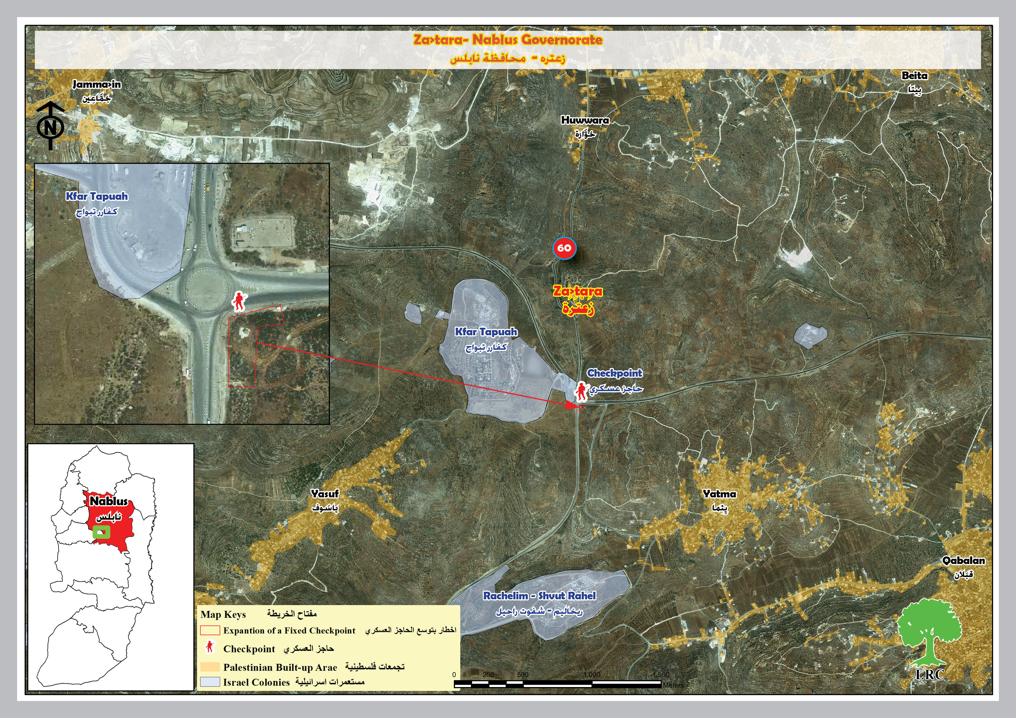
Location: Near Za'tara military checkpoint- Nablus governorate
Perpetrators: The Israeli occupation army

Details:

On June 01, 2014, the Israeli occupation, through the Israeli Military Coalition Office, handed the Palestinian side a military order under the number of (T/11/14) signed by the Israeli occupation Army High Commander in the West Bank.

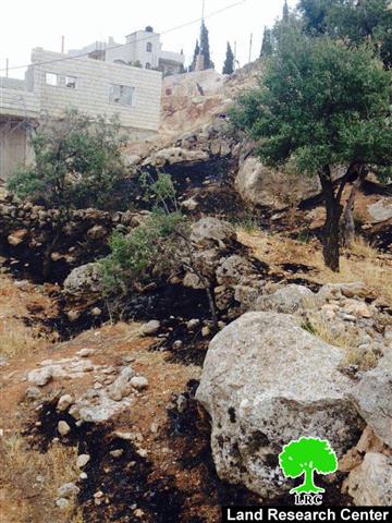
According to the order and  attached maps, there is a land takeover (land grab) on a 723- dunum piece of land in the eastern part of Yasuf village, in the natural block no. 14 of the village. The confiscated piece is adjacent to Za'tara military checkpoint.


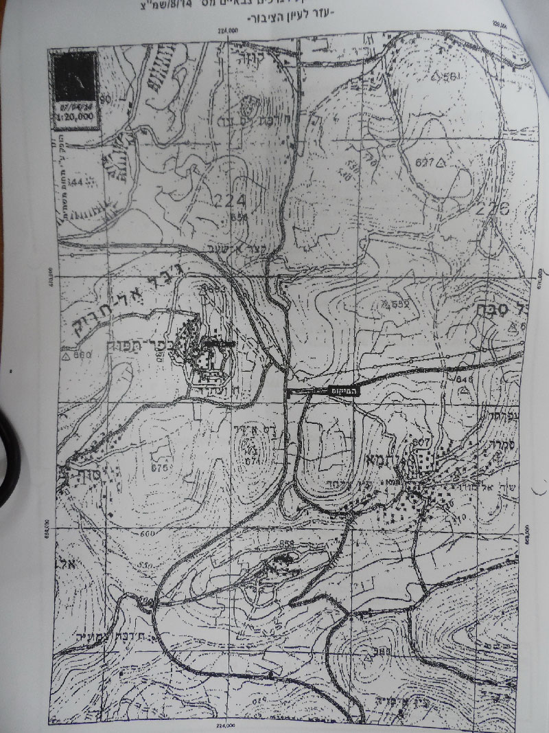
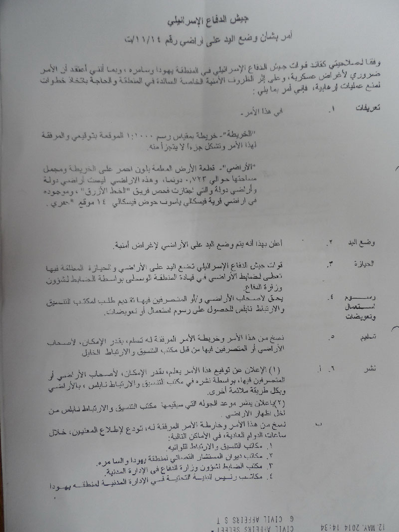
Pictures 1-3: The military order attached with maps


Establishment of a new control point (military watchtower) to reinforce occupation:

According to field research,  LRC found that the Israeli occupation settled and ravaged a piece of land, fenced it and set up  a new watchtower on it that serves the Israeli occupation's interests only as it is at the intersection between roads no. 60 and no. 505 and located near the Za'tara checkpoint.

The reason behind the installment of the military tower is to enhance the status of the Za'tara checkpoint and impose more movement restrictions on Palestinians traveling from and to the north and middle of the West Bank especially that Za'tara works as a barrier between the north of the West Bank and its middle.


Picture 4: The location of the targeted land on which a military tower has been recently set up – near the checkpoint/ Nablus

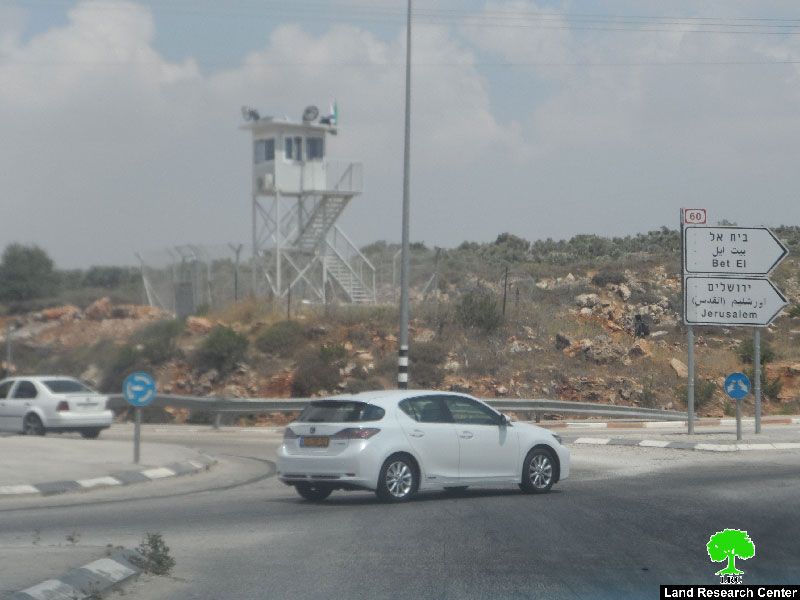
Picture 2: The checkpoint of Za'tara


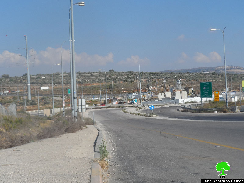
Za'tara Checkpoint as a Means of Humiliating Palestinians:

Built during the second intifada in 2002, the Za'tara checkpoint , as other military barriers, contributed and still does in strangling Palestinians and obstructing their access to and from the north West Bank cities and Ramallah.

Za'tara is a fixed checkpoint where Israeli soldiers are always present, scrutinizing vehicles and citizens. There is an observation tower and a park for inspecting cars. There is also a place for a rest stop for colonists travelling to the north of West Bank.

However, Za'tara is different from other checkpoints in that the soldiers use police dogs in searching civilian residents in an attempt to humiliate them; an action considered a grave breach to human rights and international law.  

Za'tara is a place where a number of Palestinians were martyred  in cold blood and in a brutal and unjustified way. The latest of whom was Ala' Awda from Huwara village who was shot dead on June 03, 2014.   


Prepared by
 The Land Research Center
LRC
 

Recommended For You

” المواقع الأثرية في محافظة نابلس… ساحة مفتوحة أمام مخططات المصادرة الإسرائيلية “

by arij
August 26, 2025
0
” المواقع الأثرية في محافظة نابلس… ساحة مفتوحة أمام مخططات المصادرة الإسرائيلية “

في العاشر من شهر اب من العام 2025, أصدرت الإدارة المدنية الإسرائيلية كراسة أوامر عسكرية موقعة من قبل رئيس ما يسمى "بالإدارة المدنية الإسرائيلية" في الضفة الغربية المحتلة,...

Read moreDetails

“سيطرة من تحت الأرض”, بواقع 108 أمرا عسكريا, سيطرة اسرائيلية على مياه الفلسطينيين في الضفة الغربية المحتلة

by arij
August 12, 2025
0
بواقع 86 أمرا عسكريا – الأوامر العسكرية الإسرائيلية, الأداة الرئيسية للاحتلال الاسرائيلي للسيطرة على المياه الفلسطينية في الضفة الغربية المحتلة

مقدمة، لطالما شكّلت أزمة المياه إحدى القضايا الأكثر صعوبة في الأراضي الفلسطينية المحتلة، إلا أنها في العقود القليلة الماضية اتخذت منحًنا تصاعديًا خطيرًا، حتى بلغت مستويات غير مسبوقة....

Read moreDetails

تهويد صامت بالأمتار: الطريق إلى بني كيديم خطوة نحو الشرعنة الاستيطانية

by arij
July 16, 2025
0
تهويد صامت بالأمتار: الطريق إلى بني كيديم خطوة نحو الشرعنة الاستيطانية

في الثامن عشر من شهر حزيران من العام 2025، تسلّم أهالي بلدتي سعير والشيوخ الواقعتين شمال شرق محافظة الخليل أمراً عسكرياً إسرائيلياً جديداً يقضي بمصادرة 4.8 دونما من...

Read moreDetails

من غير شرعية إلى واقع مفروض, البؤرة الاستيطانية سدي بوعز في رعاية الاحتلال

by arij
July 15, 2025
0

في الثامن من شهر تموز من العام 2025، سلّمت سلطات الاحتلال الإسرائيلي أمرًا عسكريًا جديدًا يقضي بمصادرة أراضٍ فلسطينية وممتلكات خاصة في بلدة الخضر جنوب غرب محافظة بيت...

Read moreDetails

ملاخي هشالوم: أكثر من مجرد بؤرة استيطانية … مشروع تهويد وتوسّع اسرائيلي

by arij
July 10, 2025
0
ملاخي هشالوم: أكثر من مجرد بؤرة استيطانية … مشروع تهويد وتوسّع اسرائيلي

قامت سلطات الاحتلال الإسرائيلي بتاريخ 7 تموز 2025 بنشر أمر عسكري جديد في الضفة الغربية المحتلة، يحمل عنوان: "أمر بشأن الأملاك الحكومية (يهودا والسامرة) (رقم 59) لسنة 1967"....

Read moreDetails
Next Post
الاحتلال الإسرائيلي يتسبب في إحراق 11 شجرة لوزيات في قرية المغير

الاحتلال الإسرائيلي يتسبب في إحراق 11 شجرة لوزيات في قرية المغير

LATEST NEWS

Israeli Breach of the Hebron Agreement through the Establishment of a New Settlement in Area (H1)

Israeli Breach of the Hebron Agreement through the Establishment of a New Settlement in Area (H1)

by arij
August 26, 2025
0

........................................................

خرق إسرائيلي لاتفاقية الخليل بإنشاء مستوطنة جديدة في منطقة (H1)

خرق إسرائيلي لاتفاقية الخليل بإنشاء مستوطنة جديدة في منطقة (H1)

by arij
August 26, 2025
0

........................................................

” المواقع الأثرية في محافظة نابلس… ساحة مفتوحة أمام مخططات المصادرة الإسرائيلية “

” المواقع الأثرية في محافظة نابلس… ساحة مفتوحة أمام مخططات المصادرة الإسرائيلية “

by arij
August 26, 2025
0

........................................................

مشروع (E1): الضربة القاضية لحل الدولتين وإعادة تشكيل الخريطة الجيوسياسية للضفة الغربية

The Government Pushes Forward Plans in E1, Considered a Death Blow to the Two-State Solution

by arij
August 16, 2025
0

........................................................

flag_yellow_lowEU-PfP-Logo

This website has been produced with the assistance of the European Union. The contents of this publication are the sole responsibility of ARIJ & LRC and can in no way be taken to reflect the views of the European Union.

© 2025 Copyright ARIJ . All Rights reserved. .

No Result
View All Result
  • Home
  • Settlements
    • New Israeli Settlements
    • Settlement Expansion
  • Israeli Violations
    • Agriculture
    • Confiscation
    • Demolition
    • Environment
    • Eviction of Palestinians
    • Settlers Attacks
  • Bypass Roads
  • Israeli Plans
  • Segregation
    • Checkpoints
    • Closure
    • Separation Plans
  • Military Orders
  • Reports
    • Daily Report
    • Monthly Report
    • Quarterly Report

© 2025 Copyright ARIJ . All Rights reserved. .