• About The Project
  • Palestine in Century
  • Selected Maps
  • Glossary
  • About ARIJ
  • About LRC
  • By Year
    • Case Studies By Year
    • Daily Report By Year
Tuesday, October 14, 2025
POICA
No Result
View All Result
  • Home
  • Settlements
    • New Israeli Settlements
    • Settlement Expansion
  • Israeli Violations
    • Agriculture
    • Confiscation
    • Demolition
    • Environment
    • Eviction of Palestinians
    • Settlers Attacks
  • Bypass Roads
  • Israeli Plans
  • Segregation
    • Checkpoints
    • Closure
    • Separation Plans
  • Military Orders
  • Reports
    • Daily Report
    • Monthly Report
    • Quarterly Report
No Result
View All Result
POICA
No Result
View All Result

Turning an agricultural area into a closed archaeological site in Fasayil El-Wista

May 4, 2014
in Israeli Plans
Turning an agricultural area into a closed archaeological site in Fasayil El-Wista


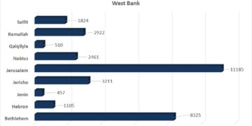
Violation:  agricultural lands adjoined to archeological site in Jericho
Date: May 04, 2014
Location: Fasayil el-Wista
Perpetrators: Civil Administration of the Israeli occupation
Victims: residents of the village

Details:

The village has always been a target for colonial plans. 17 km away from Jericho, the villagers have not been safe from the expelling attempts that in this regard served at the so called the Jordan Valley Annexation to the state of Israel.

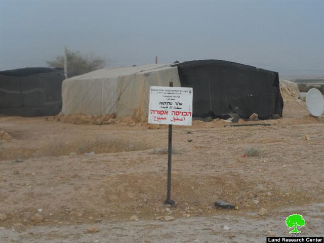
It is marked that the Ministry of Tourism and Antiquities pined directory signs stating “an inaccessible archeological site” written in Hebrew and Arabic in the southern part of Fasayil el-Wista. Noteworthy, the aforementioned area is located nearby the bypass road no.90 and is considered a shelter for Bedouins for what it has of land fertility spread on 50dunums which is in other words the only source of living available for residents.

The legal consultant of Jericho governorate Mr Hani Zoubidat, in regard to the occupation plan, stated: “in the beginning of the current year, the occupation embarked unidentifiable excavation works in the village where all roads were shut down as a result. The pretext came under finding some archeological antiquities in the area that the occupation most probably refers to them as Jewish.


Photos 1-2: the pined directory signs

Zoubidat also added: “the only victim in this process is the residents of the village for the occupation took over their fertile agricultural lands. The ravaging acts gave the occupation the chance to expel around 680 Bedouin residents. Noteworthy, the occupation denied the residents of the village as opposed to the village itself”.

 Additionally, Jericho minister of Local Government , Ismael Abu Khrabish to LRC asserted that: “Israel raced time to distort facts and history and to loot the natural resources of the Palestinian al-Ghoor for the favor of Judaizing the area. The occupation aimed at convincing the world that it had a history in this very place which would justify its presence in al-Ghoor areas. In synchronization with the aforementioned, the occupation continued confiscating lands, expelling people out of their homes and banning them from using these lands. The core of that intense plan was implemented in the village of Fasayil.

 It is notable that the targeted area totals around 50 agricultural dunums  that are inhabited by six Bedouin families destined to forcefully leave their residences.

About the town:

Fasayil is an object of recurrent demolition and evacuation operations by the Israeli occupation. They are also deprived from the basic services like water and electricity. They are forced to buy water, 15 NIS for a 1 m3 . People of Fasayil are drained by poverty, hunger and the nonstop Israeli attacks.

Fasayil is 23 km north of Jericho and its built-up area is 194 dunums only.

It has a population of 1132 (according to Palestinian Central Bureau of Statistics in 2010). It is surrounded by a number of illegal Israeli colonies that limit the expansion of the village and deprive its inhabitants from having a normal life. 

From the north, Fasayil is surrounded by colonies of Yafit and Pezael (Fezael), Tomer and Gilgal and Netiv Hagedud from the south in addition to a bypass that links the northern colonies with the southern ones. 


Prepared by
The Land Research Center
LRC

Recommended For You

الرئاسة الثانية لترامب: فرصة متجددة لطموحات إسرائيل التوسعية – ضم غور الأردن والتداعيات على حل الدولتين واستقرار المنطقة

by arij
October 14, 2025
0
Annexation of the Jordan Valley: Implications for the Two-State Solution and Regional Stability

تجددت مساعي وطموحات إسرائيل لضم غور الأردن، مع فترة الرئاسة الثانية للرئيس الأمريكي دونالد ترامب وبتأييد من ائتلاف رئيس الوزراء بنيامين نتنياهو اليميني المتطرف، والتي أصبحت نقطة تحول...

Read moreDetails

محافظة أريحا على خريطة المصادرة الإسرائيلية- إسرائيل تسعى للاستحواذ على أكثر من 7000 دونم في منطقة النبي موسى

by arij
October 13, 2025
0
محافظة أريحا على خريطة المصادرة الإسرائيلية- إسرائيل تسعى للاستحواذ على أكثر من 7000 دونم في منطقة النبي موسى

في العاشر من شهر أيلول من العام 2025، نشرت ما تُسمّى "بدائرة أراضي إسرائيل" ستة إعلانات جديدة مفادها بأن ما يُعرف بـ*"المسؤول عن أملاك الحكومة"* في الضفة الغربية...

Read moreDetails

Annexation of the Jordan Valley: Implications for the Two-State Solution and Regional Stability

by arij
September 29, 2025
0
Annexation of the Jordan Valley: Implications for the Two-State Solution and Regional Stability

  The potential annexation of the Jordan Valley by Israel, emboldened by U.S. President Donald Trump’s second term and supported by Prime Minister Benjamin Netanyahu’s far-right coalition, presents...

Read moreDetails

عزل ثلاث قرى فلسطينية شمال غرب مدينة القدس: الضم الاسرائيلي الصامت يزحف نحو محيط العاصمة

by arij
September 24, 2025
0
Isolation of Three Villages Northwest of Jerusalem: Silent Annexation Creeps toward the Capital

مقدمة في خطوة تجسد سياسة الضم الزاحف التي تنتهجها إسرائيل منذ عقود، وجدت ثلاث قرى فلسطينية تقع إلى الشمال الغربي من مدينة القدس، بيت إكسا، النبي صموئيل، وحي...

Read moreDetails

Isolation of Three Villages Northwest of Jerusalem: Silent Annexation Creeps toward the Capital

by arij
September 24, 2025
0
Isolation of Three Villages Northwest of Jerusalem: Silent Annexation Creeps toward the Capital

Introduction In a move that embodies Israel’s creeping annexation policy pursued for decades, three Palestinian villages located northwest of Jerusalem: Beit Iksa, Nabi Samuel, and Al-Khalaila, suddenly found...

Read moreDetails
Next Post
الانتهاكات الإسرائيلية في القدس المحتلة خلال شهر نيسان من العام 2014

الانتهاكات الإسرائيلية في القدس المحتلة خلال شهر نيسان من العام 2014

LATEST NEWS

Annexation of the Jordan Valley: Implications for the Two-State Solution and Regional Stability

الرئاسة الثانية لترامب: فرصة متجددة لطموحات إسرائيل التوسعية – ضم غور الأردن والتداعيات على حل الدولتين واستقرار المنطقة

by arij
October 14, 2025
0

........................................................

محافظة أريحا على خريطة المصادرة الإسرائيلية- إسرائيل تسعى للاستحواذ على أكثر من 7000 دونم في منطقة النبي موسى

محافظة أريحا على خريطة المصادرة الإسرائيلية- إسرائيل تسعى للاستحواذ على أكثر من 7000 دونم في منطقة النبي موسى

by arij
October 13, 2025
0

........................................................

ما يزيد عن 1900 دونما من الأراضي الفلسطينية في بيت لحم مهددة بالعزل لصالح مستوطنة افراتا

ما يزيد عن 1900 دونما من الأراضي الفلسطينية في بيت لحم مهددة بالعزل لصالح مستوطنة افراتا

by arij
October 8, 2025
0

........................................................

Annexation of the Jordan Valley: Implications for the Two-State Solution and Regional Stability

Annexation of the Jordan Valley: Implications for the Two-State Solution and Regional Stability

by arij
September 29, 2025
0

........................................................

flag_yellow_lowEU-PfP-Logo

This website and its content were initiated in 1993 by the Applied Research Institute – Jerusalem (ARIJ) and the Land Research Center (LRC) with the support from the European Union up until 2023. Since then, the Applied Research Institute – Jerusalem (ARIJ) has taken over the continued development and maintenance of the website. The views expressed remain solely those of ARIJ) and do not necessarily reflect those of the European Union.

© 2025 Copyright ARIJ . All Rights reserved. .

No Result
View All Result
  • Home
  • Settlements
    • New Israeli Settlements
    • Settlement Expansion
  • Israeli Violations
    • Agriculture
    • Confiscation
    • Demolition
    • Environment
    • Eviction of Palestinians
    • Settlers Attacks
  • Bypass Roads
  • Israeli Plans
  • Segregation
    • Checkpoints
    • Closure
    • Separation Plans
  • Military Orders
  • Reports
    • Daily Report
    • Monthly Report
    • Quarterly Report

© 2025 Copyright ARIJ . All Rights reserved. .