• About The Project
  • Palestine in Century
  • Selected Maps
  • Glossary
  • About ARIJ
  • About LRC
  • By Year
    • Case Studies By Year
    • Daily Report By Year
Friday, October 3, 2025
POICA
No Result
View All Result
  • Home
  • Settlements
    • New Israeli Settlements
    • Settlement Expansion
  • Israeli Violations
    • Agriculture
    • Confiscation
    • Demolition
    • Environment
    • Eviction of Palestinians
    • Settlers Attacks
  • Bypass Roads
  • Israeli Plans
  • Segregation
    • Checkpoints
    • Closure
    • Separation Plans
  • Military Orders
  • Reports
    • Daily Report
    • Monthly Report
    • Quarterly Report
No Result
View All Result
POICA
No Result
View All Result

The Israeli occupation publishes a number of maps confirming that the Jordan Valley is but part of the Israeli state

February 7, 2014
in Israeli Violations
The Israeli occupation publishes a number of maps confirming that the Jordan Valley is but part of the Israeli state

Violation: The Israeli occupation published provocative maps

Location: The Jordan Valley- Tubas governorate

Date: 06/02/2014

Perpetrators: The Israeli occupation army

Details:

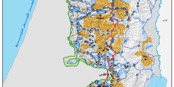
As part of the plan to take over the Jordan Valley, the Israeli Ministry of Tourism published enticing maps accentuating that the Valley is part of the Israeli state. The importance of the region springs from its strategic location and being the eastern borderline according to Israel. The maps were published in Hebrew and were set up on large billboards along road no. 90 that passes through the Valley. A detailed outline of the Palestinian lands in the Jordan Valley now considered part of Israel was also published. The outline included Israeli colonies and archaeological sites which were seized by the occupation that Judaized them and changed their names in addition to the numbers and names of the roads that cross the Valley and link it to Israel in further confirmation that the Valley is considered Israeli land. It should be remarked that the maps excluded the Palestinian Bedouin dwellings and random gatherings in the Jordan Valley.

Mr. Aref Daraghmeh, Mayor of the Bedouin dwellings in Wadi Al Maleh, stated to an LRC observer that: “There is an Israeli plan to forge the history and reality of the region by making fake maps that reflect Israel’s policy that considers colonies a reality while it does not acknowledge the Palestinian Bedouin dwellings whose residents inherited the land from their ancestors for tenths of years ago.”

The step was taken after the Israeli government’s resolution to consider the Jordan Valley an indispensable part of the Israeli state and cannot be compromised with any future peace talks with the Palestinians.


Pictures 1+2: Some inciting maps of the Jordan Valley

Prepared by
 The Land Research Center
LRC
 

Recommended For You

تصعيد إسرائيلي جديد: الاحتلال يهدم مبنى في بيت لحم ويواصل سياسة التطهير المكاني

by arij
August 12, 2025
0
تصعيد إسرائيلي جديد: الاحتلال يهدم مبنى في بيت لحم ويواصل سياسة التطهير المكاني

في استمرار لسياسة الهدم والتضييق التي تنتهجها سلطات الاحتلال الإسرائيلي بحق الفلسطينيين وممتلكاتهم، نفذت آليات وجرافات تابعة لقوات الاحتلال، صباح اليوم الأربعاء 6 آب 2025، عملية هدم واسعة...

Read moreDetails

Villages and Communities of Masafer Yatta: A Model of the Forced Displacement of Palestinian Communities in Area “C”

by arij
August 2, 2025
0
Villages and Communities of Masafer Yatta: A Model of the Forced Displacement of Palestinian Communities in Area “C”

Introduction: Since its occupation of the West Bank in 1967, Israel has pursued a long-term policy aimed at minimizing Palestinian presence in Area “C”, which constitutes approximately 61%...

Read moreDetails

قرى وتجمعات مسافر يطا: نموذج تهجير التجمعات الفلسطينية في المنطقة “ج” سياسة ممنهجة لاقتلاع الوجود الفلسطيني

by arij
August 6, 2025
0
قرى وتجمعات مسافر يطا: نموذج تهجير التجمعات الفلسطينية في المنطقة “ج” سياسة ممنهجة لاقتلاع الوجود الفلسطيني

مقدمة: منذ احتلالها للضفة الغربية عام 1967، تنتهج إسرائيل سياسة طويلة الأمد تهدف إلى تقليص الوجود الفلسطيني في المناطق المصنفة "ج"، التي تشكل ما نسبته 61% من الضفة...

Read moreDetails

قرية النعمان ضحية خطوة تهويديه أخرى: بلدية القدس الإسرائيلية تستهدف ديمغرافيا الوجود الفلسطيني

by arij
August 6, 2025
0

في خطوة تصعيدية جديدة ضمن سلسلة من الإجراءات التهويدية، أخطرت سلطات الاحتلال الإسرائيلي بتاريخ الثلاثين من تموز 2025 كافة منازل قرية النعمان الواقعة شمال شرق بيت لحم وجنوب...

Read moreDetails

Nu’man Village: A Victim of another Judaization Campaign

by arij
August 2, 2025
0
Nu’man Village: A Victim of another Judaization Campaign

In a new escalation within a systematic Judaization campaign, Israeli municipality of Jerusalem issued mass demolition orders on July 30, 2025, targeting all homes in the village of...

Read moreDetails
Next Post
إخطار مواطنٍ من خربة ” يرزا ”  باقتلاع 1000 غرسة زيتون من أرضه

إخطار مواطنٍ من خربة " يرزا " باقتلاع 1000 غرسة زيتون من أرضه

LATEST NEWS

Annexation of the Jordan Valley: Implications for the Two-State Solution and Regional Stability

Annexation of the Jordan Valley: Implications for the Two-State Solution and Regional Stability

by arij
September 29, 2025
0

........................................................

Isolation of Three Villages Northwest of Jerusalem: Silent Annexation Creeps toward the Capital

عزل ثلاث قرى فلسطينية شمال غرب مدينة القدس: الضم الاسرائيلي الصامت يزحف نحو محيط العاصمة

by arij
September 24, 2025
0

........................................................

Isolation of Three Villages Northwest of Jerusalem: Silent Annexation Creeps toward the Capital

Isolation of Three Villages Northwest of Jerusalem: Silent Annexation Creeps toward the Capital

by arij
September 24, 2025
0

........................................................

سياسات التهويد في القدس: من السيطرة المكانية إلى طمس الهوية عبر التسمية

سياسات التهويد في القدس: من السيطرة المكانية إلى طمس الهوية عبر التسمية

by arij
September 23, 2025
0

........................................................

flag_yellow_lowEU-PfP-Logo

This website and its content were initiated in 1993 by the Applied Research Institute – Jerusalem (ARIJ) and the Land Research Center (LRC) with the support from the European Union up until 2023. Since then, the Applied Research Institute – Jerusalem (ARIJ) has taken over the continued development and maintenance of the website. The views expressed remain solely those of ARIJ) and do not necessarily reflect those of the European Union.

© 2025 Copyright ARIJ . All Rights reserved. .

No Result
View All Result
  • Home
  • Settlements
    • New Israeli Settlements
    • Settlement Expansion
  • Israeli Violations
    • Agriculture
    • Confiscation
    • Demolition
    • Environment
    • Eviction of Palestinians
    • Settlers Attacks
  • Bypass Roads
  • Israeli Plans
  • Segregation
    • Checkpoints
    • Closure
    • Separation Plans
  • Military Orders
  • Reports
    • Daily Report
    • Monthly Report
    • Quarterly Report

© 2025 Copyright ARIJ . All Rights reserved. .