• About The Project
  • Palestine in Century
  • Selected Maps
  • Glossary
  • About ARIJ
  • About LRC
  • By Year
    • Case Studies By Year
    • Daily Report By Year
Wednesday, October 15, 2025
POICA
No Result
View All Result
  • Home
  • Settlements
    • New Israeli Settlements
    • Settlement Expansion
  • Israeli Violations
    • Agriculture
    • Confiscation
    • Demolition
    • Environment
    • Eviction of Palestinians
    • Settlers Attacks
  • Bypass Roads
  • Israeli Plans
  • Segregation
    • Checkpoints
    • Closure
    • Separation Plans
  • Military Orders
  • Reports
    • Daily Report
    • Monthly Report
    • Quarterly Report
No Result
View All Result
POICA
No Result
View All Result

The Israeli occupation closes off an agricultural road in Ramallah

September 5, 2013
in Checkpoints
The Israeli occupation closes off an agricultural road in Ramallah


Violation: Closing off an agricultural road
Location: Al Mughayyir village
Date: 03/09/2013
Perpetrators: The Israeli occupation army
Victims: More than 100 families in the village
 
Details:
 
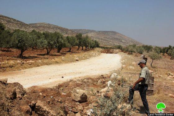
On 03/09/2013, the Israeli occupation closed off an agricultural road by earth mounds after ravaging parts of it in Al Mughayyir. It is worth mentioning that the road project was funded by Netherlands Representative Office (NRO) and administrated by Palestinian Agricultural Relief Committees (PARC) as part of Improving Livelihood in the Occupied Palestinian Territories (West Bank) Program. 


Picture 1: The closed road

 
Mr. Faraj Al-Na’san, the head of Al Mughayyir village council, told an LRC observer that: " On Tuesday night, the Israeli occupation forces set siege around the roads leading to Al Mughayyir and ravaged parts of the agricultural road where they placed earth mounds along 400 meters of the way. The Israeli occupation authorities did not inform the farmers of this sudden closure." Al-Na’san also added, " This agricultural road leads to more than 1500 dunum lands, 400 dunums of which are planted with olive trees that serve 150 families. The road is near the bypass Elon and Adi Ad colony."
 
The colonists already carried out attacks on agricultural lands in Al Mughayyir in the past years. They uprooted olive trees and set crops to fire in addition to other attacks deemed futile by Al Mughayyir farmers.
 
Al Mughayyir in lines:
 
Located in the north eastern part of Ramallah, Al Mughayyir has a population of 2900 people, according to a 2010 census prepared by Palestinian Central Bureau of Statistics. Most Al Mughayyir agricultural lands are located in the eastern part of the village and reach up to the verge of the Jordan Valley. Its total area before the Israeli occupation of 1967 is 33,000 dunums.  After the Israeli occupation in 1967, the Israeli occupation declared the Jordan Valley a closed military zone and so did with 27,556 dunums of Al Mughayyir lands. The occupation planted land mine; deployed military forces in the region and prohibited farmers and shepherds from entering the area under the pretext of its being a shooting zone.  
 
Al Mughayyir is surrounded with Israeli colonies which has made the village a target in itself. In the east, there are "Tomer", "Pezael", "Gilgal" and "Netiv Hagedud" colonies. In the west, there are "Shvut Rahel" and outposts of "Shilo". In the north, there are "Niran", "Yitav" and "Kokhav hashahar" colonies. While in the north there are "Migdalim" and "Maale Efrayim".  


Prepared by
 The Land Research Center
LRC


Recommended For You

عقاب جماعي يومي: الفلسطينيون تحت هيمنة الحواجز العسكرية

by arij
September 24, 2025
0
عقاب جماعي يومي: الفلسطينيون تحت هيمنة الحواجز العسكرية

تشهد الضفة الغربية المحتلة واقعًا خانقًا نتيجة السياسات الإسرائيلية المتمثلة بفرض المزيد من الحواجز العسكرية اليومية والإغلاقات، والتي باتت أداة منهجية للسيطرة والتحكم بحياة الفلسطينيين اليومية، وليست مجرد...

Read moreDetails

الحرب على قطاع غزة وتأثيرها على محافظة الخليل جنوب الضفة الغربية

by arij
November 30, 2023
0

  تقع محافظة الخليل في الجزء الجنوبي من الضفة الغربية المحتلة، إلى الجنوب من مدينة القدس، وعلى بعد حوالي 36 كم منها. يحدها من الشمال محافظة بيت لحم،...

Read moreDetails

تطبيق سياسة الفصل العنصري على استخدام الطرق الرئيسية في الضفة الغربية وتقيد حركة وتنقل المواطنين الفلسطينيين

by arij
November 22, 2023
0
معاناة شجرة الزيتون الفلسطينية بسبب الاحتلال والاستيطان في العام 2023

  بناء على تقديرات مراقبين دوليين يبلغ عدد الحواجز الإسرائيلية في الضفة الغربية أكثر من 567 حاجز إسرائيلي متعددة الاشكال منها 77 حاجزًا رئيسيًا وجزئي تتحكم في حركة...

Read moreDetails

The Instigation of Apartheid Roads Era: Israel blocks Palestinian movement inside West Bank Governorates

by arij
November 22, 2023
0

  According to international observers, Israel constrains the West Bank territory with 567 various types of obstacles; 77 of which are main checkpoints and partial checkpoints that control...

Read moreDetails

Between “Ben Gavir” and Netanyahu Not Oblivious but Vindictive, The reality of Israeli Apartheid Stands in the occupied Palestinian territory

by arij
September 13, 2023
0
Between “Ben Gavir” and Netanyahu Not Oblivious but Vindictive, The reality of Israeli Apartheid Stands in the occupied Palestinian territory

  In the wake of the overwhelming Israeli settlers and the Israeli occupation government increasing their wave of attacks and assaults on the Palestinian people (more than 700...

Read moreDetails
Next Post

ARIJ Daily Report - Fri, 06/09/2013

LATEST NEWS

Annexation of the Jordan Valley: Implications for the Two-State Solution and Regional Stability

الرئاسة الثانية لترامب: فرصة متجددة لطموحات إسرائيل التوسعية – ضم غور الأردن والتداعيات على حل الدولتين واستقرار المنطقة

by arij
October 14, 2025
0

........................................................

محافظة أريحا على خريطة المصادرة الإسرائيلية- إسرائيل تسعى للاستحواذ على أكثر من 7000 دونم في منطقة النبي موسى

محافظة أريحا على خريطة المصادرة الإسرائيلية- إسرائيل تسعى للاستحواذ على أكثر من 7000 دونم في منطقة النبي موسى

by arij
October 13, 2025
0

........................................................

ما يزيد عن 1900 دونما من الأراضي الفلسطينية في بيت لحم مهددة بالعزل لصالح مستوطنة افراتا

ما يزيد عن 1900 دونما من الأراضي الفلسطينية في بيت لحم مهددة بالعزل لصالح مستوطنة افراتا

by arij
October 8, 2025
0

........................................................

Annexation of the Jordan Valley: Implications for the Two-State Solution and Regional Stability

Annexation of the Jordan Valley: Implications for the Two-State Solution and Regional Stability

by arij
September 29, 2025
0

........................................................

flag_yellow_lowEU-PfP-Logo

This website and its content were initiated in 1993 by the Applied Research Institute – Jerusalem (ARIJ) and the Land Research Center (LRC) with the support from the European Union up until 2023. Since then, the Applied Research Institute – Jerusalem (ARIJ) has taken over the continued development and maintenance of the website. The views expressed remain solely those of ARIJ) and do not necessarily reflect those of the European Union.

© 2025 Copyright ARIJ . All Rights reserved. .

No Result
View All Result
  • Home
  • Settlements
    • New Israeli Settlements
    • Settlement Expansion
  • Israeli Violations
    • Agriculture
    • Confiscation
    • Demolition
    • Environment
    • Eviction of Palestinians
    • Settlers Attacks
  • Bypass Roads
  • Israeli Plans
  • Segregation
    • Checkpoints
    • Closure
    • Separation Plans
  • Military Orders
  • Reports
    • Daily Report
    • Monthly Report
    • Quarterly Report

© 2025 Copyright ARIJ . All Rights reserved. .