• About The Project
  • Palestine in Century
  • Selected Maps
  • Glossary
  • About ARIJ
  • About LRC
  • By Year
    • Case Studies By Year
    • Daily Report By Year
Saturday, August 16, 2025
POICA
No Result
View All Result
  • Home
  • Settlements
    • New Israeli Settlements
    • Settlement Expansion
  • Israeli Violations
    • Agriculture
    • Confiscation
    • Demolition
    • Environment
    • Eviction of Palestinians
    • Settlers Attacks
  • Bypass Roads
  • Israeli Plans
  • Segregation
    • Checkpoints
    • Closure
    • Separation Plans
  • Military Orders
  • Reports
    • Daily Report
    • Monthly Report
    • Quarterly Report
No Result
View All Result
POICA
No Result
View All Result

Setting 75 dunums Ablaze in Ksfr Malek village

May 30, 2012
in Israeli Violations
Setting 75 dunums Ablaze in Ksfr Malek village


Violation: setting 75 dunums alight.

Date: May 30, 2012.

Perpetrators: colonists of Kohab Hashihar.

Victims: villagers of Kafr Malek.

Location: Khallit ‘al Abhara’, east Kafr Malek.


Details:


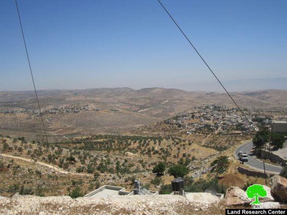
Kafr Malek is a Palestinian village that suffered much of the Israeli Occupation measures. It lost huge areas to the colony of Kohab Hashihar which was built over its lands. On May 30, 2012, colonists started a fire in the area known as ‘Khirbit al Abhara’. The flames consumed around 75 dunums of rangelands. The Israeli fire department interfered only when the raging flames got close to the colony perimeter to avoid any damage.


Picture 1: burned lands


Baker at Tarshan of Kafr Malek Village Council said: ‘the targeted lands were grains fields till the year 2000 when they became inaccessible on claims that the area is closed military zone. This has turned the lands into barren lands, fairly good enough to be used as rangelands. While it is inaccessible to the Palestinians, colonists roam the lands freely to serve the Israeli colonization plans. In addition, the Israeli Army has conducted a huge skirmish in the area. It is inevitable that the Israelis will capture the rest of the lands there‘.


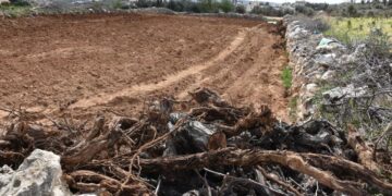
Closure of the eastern entrance of Kafr Malek:


At the same time, the Israeli blockade of the village eastern entrance, which connects it with the main road ‘458’ continue unabated. The road has been blocked with earth mounds and rocks since 2001. It must be noted that the blocked entrance have been connecting the village with farms n the Jordan Valley area since the 1940’s. However, since its closure, farmers are forced to drive an extra 19 km to get to their farms.


Picture 2: blocked


Kafr Malek:


It is located 17 km to the north east of Ramallah; its borders extend to reach Al Auja river (east), Al Mazra’a al Sharqiyya (west), Al Mughayer (north), and Deir Jrer and At Tayba (south).


Picture 3: Kafr Malek


The village total area is 54,000 dunums including 2860 dunums of built up area. It is inhabited by around 3600 people in addition to 4000 of Diasporas. Kafr Malek is known for having archeological sites and traces of many civilizations (Armenians, Byzantines, Romans, Muslims, etc).


Prepared by
 The Land Research Center
LRC


Recommended For You

تصعيد إسرائيلي جديد: الاحتلال يهدم مبنى في بيت لحم ويواصل سياسة التطهير المكاني

by arij
August 12, 2025
0
تصعيد إسرائيلي جديد: الاحتلال يهدم مبنى في بيت لحم ويواصل سياسة التطهير المكاني

في استمرار لسياسة الهدم والتضييق التي تنتهجها سلطات الاحتلال الإسرائيلي بحق الفلسطينيين وممتلكاتهم، نفذت آليات وجرافات تابعة لقوات الاحتلال، صباح اليوم الأربعاء 6 آب 2025، عملية هدم واسعة...

Read moreDetails

Villages and Communities of Masafer Yatta: A Model of the Forced Displacement of Palestinian Communities in Area “C”

by arij
August 2, 2025
0
Villages and Communities of Masafer Yatta: A Model of the Forced Displacement of Palestinian Communities in Area “C”

Introduction: Since its occupation of the West Bank in 1967, Israel has pursued a long-term policy aimed at minimizing Palestinian presence in Area “C”, which constitutes approximately 61%...

Read moreDetails

قرى وتجمعات مسافر يطا: نموذج تهجير التجمعات الفلسطينية في المنطقة “ج” سياسة ممنهجة لاقتلاع الوجود الفلسطيني

by arij
August 6, 2025
0
قرى وتجمعات مسافر يطا: نموذج تهجير التجمعات الفلسطينية في المنطقة “ج” سياسة ممنهجة لاقتلاع الوجود الفلسطيني

مقدمة: منذ احتلالها للضفة الغربية عام 1967، تنتهج إسرائيل سياسة طويلة الأمد تهدف إلى تقليص الوجود الفلسطيني في المناطق المصنفة "ج"، التي تشكل ما نسبته 61% من الضفة...

Read moreDetails

قرية النعمان ضحية خطوة تهويديه أخرى: بلدية القدس الإسرائيلية تستهدف ديمغرافيا الوجود الفلسطيني

by arij
August 6, 2025
0

في خطوة تصعيدية جديدة ضمن سلسلة من الإجراءات التهويدية، أخطرت سلطات الاحتلال الإسرائيلي بتاريخ الثلاثين من تموز 2025 كافة منازل قرية النعمان الواقعة شمال شرق بيت لحم وجنوب...

Read moreDetails

Nu’man Village: A Victim of another Judaization Campaign

by arij
August 2, 2025
0
Nu’man Village: A Victim of another Judaization Campaign

In a new escalation within a systematic Judaization campaign, Israeli municipality of Jerusalem issued mass demolition orders on July 30, 2025, targeting all homes in the village of...

Read moreDetails
Next Post
Stop-work Orders in Hijja village – Qalqilyia Governorate

Stop-work Orders in Hijja village - Qalqilyia Governorate

LATEST NEWS

مشروع (E1): الضربة القاضية لحل الدولتين وإعادة تشكيل الخريطة الجيوسياسية للضفة الغربية

The Government Pushes Forward Plans in E1, Considered a Death Blow to the Two-State Solution

by arij
August 16, 2025
0

........................................................

مشروع (E1): الضربة القاضية لحل الدولتين وإعادة تشكيل الخريطة الجيوسياسية للضفة الغربية

مشروع (E1): الضربة القاضية لحل الدولتين وإعادة تشكيل الخريطة الجيوسياسية للضفة الغربية

by arij
August 16, 2025
0

........................................................

بواقع 86 أمرا عسكريا – الأوامر العسكرية الإسرائيلية, الأداة الرئيسية للاحتلال الاسرائيلي للسيطرة على المياه الفلسطينية في الضفة الغربية المحتلة

“سيطرة من تحت الأرض”, بواقع 108 أمرا عسكريا, سيطرة اسرائيلية على مياه الفلسطينيين في الضفة الغربية المحتلة

by arij
August 12, 2025
0

........................................................

تصعيد إسرائيلي جديد: الاحتلال يهدم مبنى في بيت لحم ويواصل سياسة التطهير المكاني

تصعيد إسرائيلي جديد: الاحتلال يهدم مبنى في بيت لحم ويواصل سياسة التطهير المكاني

by arij
August 12, 2025
0

........................................................

flag_yellow_lowEU-PfP-Logo

This website has been produced with the assistance of the European Union. The contents of this publication are the sole responsibility of ARIJ & LRC and can in no way be taken to reflect the views of the European Union.

© 2025 Copyright ARIJ . All Rights reserved. .

No Result
View All Result
  • Home
  • Settlements
    • New Israeli Settlements
    • Settlement Expansion
  • Israeli Violations
    • Agriculture
    • Confiscation
    • Demolition
    • Environment
    • Eviction of Palestinians
    • Settlers Attacks
  • Bypass Roads
  • Israeli Plans
  • Segregation
    • Checkpoints
    • Closure
    • Separation Plans
  • Military Orders
  • Reports
    • Daily Report
    • Monthly Report
    • Quarterly Report

© 2025 Copyright ARIJ . All Rights reserved. .