• About The Project
  • Palestine in Century
  • Selected Maps
  • Glossary
  • About ARIJ
  • About LRC
  • By Year
    • Case Studies By Year
    • Daily Report By Year
Tuesday, July 1, 2025
POICA
No Result
View All Result
  • Home
  • Settlements
    • New Israeli Settlements
    • Settlement Expansion
  • Israeli Violations
    • Agriculture
    • Confiscation
    • Demolition
    • Environment
    • Eviction of Palestinians
    • Settlers Attacks
  • Bypass Roads
  • Israeli Plans
  • Segregation
    • Checkpoints
    • Closure
    • Separation Plans
  • Military Orders
  • Reports
    • Daily Report
    • Monthly Report
    • Quarterly Report
No Result
View All Result
POICA
No Result
View All Result

Blocking an Agricultural Road in Al Khader Village

May 10, 2012
in Closure
Blocking an Agricultural Road in Al Khader Village
Violation: blocking an agricultural road leading to ‘Ein Qissis’ and ‘Wadi al Abyar’ areas.
Location: Al Khader town – Bethlehem.
Date: May 9, 2012.
Perpetrators: the Israeli Occupation Army.
Victims: families of Al Khader.
 
Details:
 
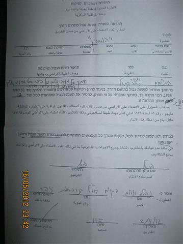
On May 9, 2012, the Israeli Occupation Army blocked an agricultural road leading to Ein Qissis and Wadi al Abyar areas, around 5,000 dunums in area. The Israeli Occupation Army placed a blocking notification which was found by a farmer who handed it to the Municipality eight days earlier. This has rendered tens of farmers unable to reach their lands forcing the farmers and the Municipality to look for alternatives. The farmers are worried that this is a step towards taking over the lands.  
Picture 1: notification
Al Khader:
 
Al Khader is located 4.5 km to the west of Bethlehem city; it is connected by a road to the main road, Jerusalem – Hebron road which connects it to the surrounding cities. It is administered by a local council and is named after Saint George (Al Khader in Arabic). The village holds within a football stadium, a donation of the Portuguese Government; the work in the stadium started in 2000 through Bethlehem 2000  project, however, the construction stopped for a long time because of the second Intifada (uprising)  events considering the location of the stadium near by-pass road (60). It was opened in 2007.
 
Area and Location:
 
Al Khader is 20100 dunums in area including 800 dunums of built-up area.
 
Previous violations:
 
The Israelis conquered 218 dunums of the village in 1948 and are trying to capture the rest of Al Khader fertile lands using the segregation wall. The Israeli authorities confiscated huge parts og Al Khader lands to construct Ezyon colony in 1967(4500 dunums in area inhabited by 461 colonists) and Daniel in 1983 (200 dunums in area).
 
Prepared by
The Land Research Center
LRC 

Recommended For You

Israel tightens the Grip on Nablus Governorate –  الحصار يخنق محافظة نابلس 

by arij
October 20, 2022
0
Israel tightens the Grip on Nablus Governorate –  الحصار يخنق محافظة نابلس 

  The map of Israeli checkpoint stifling the daily life of more than 388 thousand Palestinians   الحصار يخنق محافظة نابلس  The Israeli Closure Policy in International Law The...

Read moreDetails

الاحتلال الإسرائيلي يغلق مدخل بلدة سلواد الجنوبي في محافظة رام الله والبيرة

by arij
November 7, 2022
0
الاحتلال الإسرائيلي يغلق مدخل بلدة سلواد الجنوبي في محافظة رام الله والبيرة

  الانتهاك: اغلاق طريق بالسواتر الترابية. الموقع: بلدة سلواد/ محافظة رام الله والبيرة. تاريخ الانتهاك: 06/10/2022م. الجهة المعتدية: جيش الاحتلال الاسرائيلي. الجهة المتضررة: أهالي بلدة سلواد. تفاصيل الانتهاك:...

Read moreDetails

إغلاق مدخل بلدة قصرة الرئيسي / محافظة نابلس

by arij
September 28, 2022
0
إغلاق مدخل بلدة قصرة الرئيسي / محافظة نابلس

  الانتهاك: إغلاق طريق. الموقع:بلدة قصرة جنوب مدينة نابلس. تاريخ الانتهاك:13 أيلول 2022م. الجهة المعتدية:جيش الاحتلال الإسرائيلي. الجهة المتضررة:أهالي بلدة قصرة والقرى المجاورة. تفاصيل الانتهاك: اقتحمت قوة كبيرة من...

Read moreDetails

Closure of the main iron gate entrance of Aboud village, Ramallah governorate

by arij
July 4, 2022
0
Closure of the main iron gate entrance of Aboud village, Ramallah governorate

  Violation: Closing the main entrance to the village. Location: Aboud village / Ramallah and Al-Bireh governorate. Violation date: 09/06/2022 AD. Perpetrators: The Israeli Occupation Army. Affected party:...

Read moreDetails

إغلاق المدخل الرئيسي بالبوابة الحديدية في قرية عابود بمحافظة رام الله

by arij
July 2, 2022
0
إغلاق المدخل الرئيسي بالبوابة الحديدية في قرية عابود بمحافظة رام الله

  الانتهاك: إغلاق المدخل الرئيسي بالبوابات الحديدية. الموقع: قرية عابود/ محافظة رام الله والبيرة. تاريخ الانتهاك: 09/06/2022م. الجهة المعتدية: جيش الاحتلال الاسرائيلي. الجهة المتضررة: سكان قرية عابود. تفاصيل...

Read moreDetails
Next Post
تمديد سريان وضع اليد على 30 دونما في بلدة ديرستيا / محافظة سلفيت

تمديد سريان وضع اليد على 30 دونما في بلدة ديرستيا / محافظة سلفيت

LATEST NEWS

أمر عسكري إسرائيلي يستهدف أراضي قرية زبوبا الفلسطينية لأغراض أمنية مستعجلة

Israeli Order Targets Zububa Village Under Security Claims

by arij
June 24, 2025
0

........................................................

أمر عسكري إسرائيلي يستهدف أراضي قرية زبوبا الفلسطينية لأغراض أمنية مستعجلة

أمر عسكري إسرائيلي يستهدف أراضي قرية زبوبا الفلسطينية لأغراض أمنية مستعجلة

by arij
June 21, 2025
0

........................................................

At the Southeast Bethlehem Governorate: Al-Minya and Kisan Villages Caught Between Forced Displacement and Israel’s Expanding Settlement Plans

At the Southeast Bethlehem Governorate: Al-Minya and Kisan Villages Caught Between Forced Displacement and Israel’s Expanding Settlement Plans

by arij
June 21, 2025
0

........................................................

جنوب شرق بيت لحم: قرى المنيا وكيسان بين مطرقة التهجير وسندان مخطط التوسع الاستيطاني الإسرائيلي

جنوب شرق بيت لحم: قرى المنيا وكيسان بين مطرقة التهجير وسندان مخطط التوسع الاستيطاني الإسرائيلي

by arij
June 21, 2025
0

........................................................

flag_yellow_lowEU-PfP-Logo

This website has been produced with the assistance of the European Union. The contents of this publication are the sole responsibility of ARIJ & LRC and can in no way be taken to reflect the views of the European Union.

© 2025 Copyright ARIJ . All Rights reserved. .

No Result
View All Result
  • Home
  • Settlements
    • New Israeli Settlements
    • Settlement Expansion
  • Israeli Violations
    • Agriculture
    • Confiscation
    • Demolition
    • Environment
    • Eviction of Palestinians
    • Settlers Attacks
  • Bypass Roads
  • Israeli Plans
  • Segregation
    • Checkpoints
    • Closure
    • Separation Plans
  • Military Orders
  • Reports
    • Daily Report
    • Monthly Report
    • Quarterly Report

© 2025 Copyright ARIJ . All Rights reserved. .