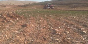
On March 15, 2012, the Israeli Army, accompanied with officers from the Israeli Civil Administration raided Beit Dajan’s lands and targeted agricultural lands in Rqaqa location, at Al-Tyour Region, at the eastern part of the village. The raid was executed early in the morning intended to uprooted 450 olive seedlings from the land that belong to the Palestinian farmer, Jamal Muhammad Kina’an. The attack was justified to reverse “according to the Israeli civil administration” an attack on what is defined military area, and for the safety of people as the targeted location falls within the Israeli Occupation Army Artillery Shooting range. See Images below for more details.
Mr. Kina’an has been farming the land for 12 years, during which the land was targeted 4 times, 3 of which by the Israeli Army, and one time by the Israeli settlers from an outpost near by Alon Moreh settlement. Table 01 shows the details of the attacks on Jamal Muhammad Kina’an’s land of Beit Dajan Village, Nablus Governorate.
|
Table 01: Details of the attacks on Jamal Muhammad Kina’an’s land, Beit Dajan Village, Nablus Governorate.
|
|
No.
|
Assailant
|
Area attacked
‘Dunums’
|
Trees uprooted
|
Date
|
|
1.
|
Israeli Settlers
|
25
|
100
|
March 2003
|
|
2.
|
Israeli Army
|
39
|
800
|
February 2007
|
|
3.
|
Israeli Army
|
30
|
500
|
March 2010
|
|
4.
|
Israeli Settlers
|
10
|
450
|
March 2011
|
|
5.
|
Israeli Army
|
15
|
450
|
March 2012
|
|
Source: Beit Dajan Local Council
ARIJ Field Team 2012
|
It is worth mentioning that the land has official ownership documents issued by the Palestinian Ministry of Finance See Form 01 & Form 02, for ownership copies. See Map 01, & Map 02 for more details.
 |
 |
| Map 1: the location of the targeted land |
Map 2: Beit Dajan eastern agricultural area |
Source: The Geographical Inofrmaiton System and Remote Sensing Unit- 2012
The Artillery Shooting range used by the Israeli Army is located some 1.5 Km away from the targeted land, The targeted land was originally confiscated along with bigger area back in 1987, under the pretext of military use, however, and following legal processes and petitions submitted by the landowners, the Israeli Army surrendered the areas back to the owners except the land of Jamal Muhammad Kina’an, for which reason remains unknown, and at every attempt by the Local council or the land owner to figure out the reason to why they still hold this particular land, the Israeli civil Administration deny their knowledge with Mr. Kina’an’s Land problem.
In July 2010, Mr. Kina’an received a military evacuation order, No. 430, from the Israeli Civil Administration, ordering him to evacuate the land within 45 days from the receiving date of the order. The order is accompanied with maps for the targeted lands. Military Order Copy No. 1, Copy No. 2, & Copy No. 3 show the received Military Order.
Military Order Copy No1 Copy No. 2 Copy No. 3
Previous Attacks:
On March 18, 2011, the Israeli settlers of Alone Moreh settlement attacked the land of Jamal Muhammad Kina’an, uprooting more than 450 olive seedlings, and razing more than 10 dunums. The attack was in Al Tyour region, in Al-Rqaqa Location.
On July 8, 2010, the Israeli Army raided Al-Rqaqa location, in Al-Tyour region, at the eastern part of the village, razing more than 30 dunums, and uprooting 500 olive seedlings, which belongs to Jamal Muhammad Kina’an, under the pretext of being in a military closed area, and being located near the Israeli Army Artillery Training Field.
On February 13, 2007, the Israeli Army raided Beit Dajan’s Eastern Agricultural area, razing more than 39 dunums and uprooted 800 olive trees, located in Al-Rqaqa – in Al-Tyour region; the razed land belong to Jamal Muhammad Kina’an.
On March 7 2003, Israeli Settlers from Mekhora attacked Jamal Muhammad Kina’an’s land in Al-Rqaqa location, in Al-Tyour region, razing more than 25 dunums and uprooting 100 olive trees.
It is worth mentioning that with every attack by the Israeli settlers and/ or the Army the uprooted trees were either confiscated or burned.
Beit Dajan:-
Beit Dajan village is located 10 Km east of Nablus Governorate, in the northern part of the West Bank. It is bordered by Yanun and Ar-Rajman villages at its south side, and by Beit Furik village and the Israeli Itamar Settlement, along with 4 outposts, Itamar 1, Itamar 2, Itamar 3, and Itamar 4 at its south eastern side. At the south western side stands Jafa An-Nun village, and the Israeli Settlement Mekhora. From the North, it is bordered with Shihda Wa Hamlan village, and at the north western side Furush Beit Dajan. As for the west, it is bordered with the Palestinian Balata Refugees Camp, and from the East, it is bordered with the Israeli Settlement Hamra.
According to the PCBS 2011, the village has a total population of 3868 people. The village has a total land area of 43997 dunums, 360 dunums of which are classified as Built-up area.
According to the Second Oslo Agreement of 1995, the land of the village was classified into ‘Area B’ & ‘Area C’. 9935 dunums (22.6%) out of 43997 dunums are classified as ‘Area B’, and the remaining 34062 dunums (77.4%) are classified as ‘Area C’.
The area that is classified as ‘Area B’, it falls under the Administrative control of the Palestinian National Authority while security related issues remains under the Israeli control. As for the areas that are classified as ‘Area C’, it falls under the full control of the Israeli Army.
It is worth mentioning that Beit Dajan Village sets between two governorates, Jericho and Nablus. 15771 dunums of the total land area of the village is located in Jericho Governorate, while 28226 dunums are located in Nablus Governorate. Furthermore, the village has a big share of its lands classified as Closed Military Area, 34004 dunums of its total land area is located in the Eastern Segregation Zone ‘ESZ’. Moreover, the village has lost more than 1807 dunums of its lands to the Israeli settlements built there: Mekhora Settlement 275 dunums, and Hamra Settlement 1532 dunums.
Conclusion:-
The Israeli policy of house demolition violates two distinct articles of the Fourth Geneva Convention that clearly render any destruction of property as illegal under international law, unless this act is crucial for military purposes. The Fourth Geneva Convention also utterly renounces any form of collective punishments.
The Israeli occupation control of P’lestinians’ lands is justified by the military orders and enacted by the Israeli Army to demolish and seize land for ‘security’ reasons. However, ‘security’ reasons are better translated to strategic, political and economic reasons, and the ongoing development of settlements is clear testament to such notion.
- Article XXXI of the 1995 Oslo agreement provides that: Israelis forbidden from building or planning to any project or settlements or any colonial expansion or any plan that lead to change the status of the West Bank and Gaza Strip. The article provides ‘Neither side shall initiate or take any step that will change the status of the West Bank and the Gaza Strip pending the outcome of the permanent status negotiations’.
- In addition, the Forth Geneva Convention also states in Article 49 that ‘The occupying power shall not deport or transfer parts of its own population into the territories it occupies’.
- The Forth Geneva Convention also states in Article 53 that: ‘Any destruction by the Occupying Power of real or personal property belonging individually or collectively to private persons, or to the State, or to other public authorities, or to social or cooperative organizations, is prohibited, except where such destruction is rendered absolutely necessary by military operations’.
- Furthermore, the existence of the Israeli settlements in the West Bank and its expansions are Illegal and in contradiction with the international law rules, United Nations Security Council Resolutions such as 237 (1967), 271 (1969), 446 (1979), 452 (1979), 465 (1980).
- According to Hague Convention signed in 1907 and signed by Israel in 1962, Art. 23: ‘In addition to the prohibitions provided by special Conventions, it is especially forbidden, (g) to destroy or seize the enemy’s property, unless such destruction or seizure is imperatively demanded by the necessities of war’.
Prepared by:


