On November 23, 2011, the Israeli Occupation Forces handed over citizens of Al Khader village west of Bethlehem city an amendment to a previously issued Israeli military order holding number 05/18/T to seize 0.012 dunums (120 m²) of lands in Al Khader village for security purpose, to install surveillance cameras in Neve Daniel settlement. Table 1: to seize 0.012 dunums (120 m²) of lands in Al Khader village for security purpose, to install surveillance cameras in Neve Daniel settlement.
|
Table 1: The seizure of lands in Al Khader village according to Military Order No. (amendment) 05/18/T
|
||
|
No.
|
Block No.
|
Parcel
|
|
1
|
5
|
86 (part of it)
|
|
2
|
8
|
48 &88
|
|
Source: Israeli Military Order No. (amendment) 05/18/T
|
||
A copy of the amendment to the military order and a location map are attached below:-

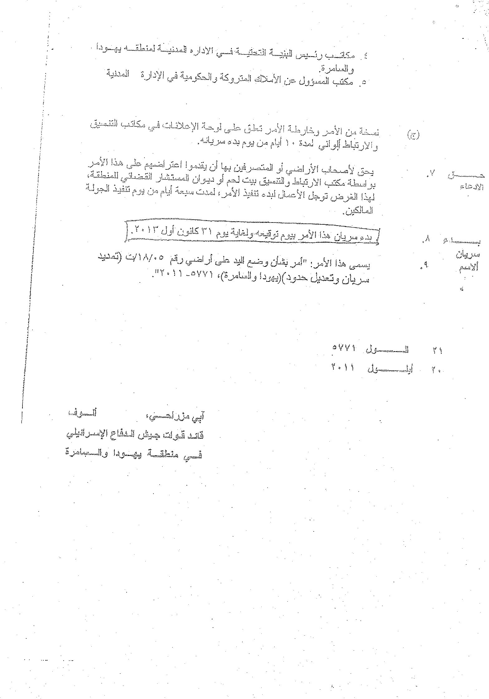
Photo 1 & 2: A copy of the amendment to the Israeli military order No. 05/18/T
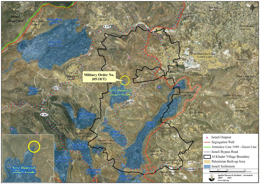
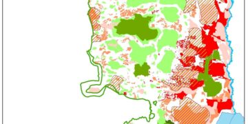
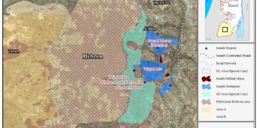
Map 1: Neve Daniel settlement located within the Gush Etzion settlement Bloc
The Israeli military order gave citizens of Al Khader village 7 days time to file objections against the military order at the office of Israeli Civil Administration or at the Offices of the juridical advisor in Judea and Samaria. It is worth pointing out that the Israeli military order was issued on September 20, 2011 but was only served to citizens of Al Khader village on the 23rd of November 2011, two months following the date of the order’s issuance. This deliberate policy will not enable citizens of Al Khader to file objections against the military order, as the order gives land owners or those acting on behalf 7 days to file objections against the military order.
The original Israeli military order (18/05/T) was served to citizens of Al Khader village on October 3, 2005 and states the seizure of 0.4 dunums (400 m²) of lands for military uses, to establish an Iron Gate at the entrance of Neve Daniel settlement.
Al Khader village: Location & Population
A Palestinian village located about 4.5 km west of Bethlehem city and houses a total population of 11700 (PCBS 2010). It is bordered by Bethlehem city from the east, Husan and Battir villages from the west and northwest, from the north and northeast Al Doha and Beit Jala cities, and the gush Etzion settlements bloc and Artas village from the southwest and south. The village’s total land area is 20090 dunums, which includes 601 dunums as built up area.
The Geopolitical Status of Al Khader village according to Oslo II Signed Agreement
According to the Oslo II Interim agreement that was signed in 1995 between the Palestinian Liberation Organization and Israel, the lands of Al Khader village are classified into areas A, B, C, where areas classified as ‘A’, the Palestinian National Authority (PNA) had complete autonomy over administrative and security issues. In areas classified as ‘B’, Palestinians have full control over the civil administration and Israel continues to have overriding responsibility for security; while areas classified as ‘C’ are those lands where Palestinians have responsibility for civil life such as economics, health, and education; while, Israel retains full control over security and administration related to the territory. See Table 2:
|
Table 2: Classification of Lands in Al Khader village according to Oslo II Agreement of 1995
|
||
|
Classification
of Area |
Area in dunums (km²)
|
% of the Village’s total area
|
|
Area A
|
565 (0.5 km²)
|
2.81
|
|
Area B
|
1176 (1.17 km²)
|
5.85
|
|
Area C
|
18349 (18.3 km²)
|
91.3
|
|
Total Area
|
20090 (km²)
|
100
|
Source: Geo-Informatics Department – ARIJ 2011
The village of Al Khader is bordered by a number of illegal Israeli settlements from its southwestern side which, throughout the years of occupation, have caused the seizing and confiscation of 2917 dunums of the village’s lands, 14.5% of the total village area. In addition, the Israeli bypass road no. 60 has also resulted in the confiscation of more of Al Khader lands to act as a link between the Israeli settlements located within the Gush Etzion settlement bloc. and the Israeli settlements in Jerusalem and those in the southern part of the West Bank (Hebron Governorate). Table 3 lists the Israeli settlements that were established on lands of Al Khader Village:
|
Table 3: Israeli Settlements established on land of Al Khader Village
|
||||
|
Settlement Name
|
Establishment
Date
|
Pop 2008-2009
|
Total Area
of settlement (Dunum) |
Lands confiscated from Al Khader village
(dunum) |
|
Rosh Zurim
|
1969
|
550
|
893
|
4
|
|
Allon Shevut
|
1971
|
3400
|
1003
|
38
|
|
Migdal ‘Oz
|
1977
|
405
|
1133
|
46
|
|
Neve Daniel
|
1982
|
1883
|
548
|
584
|
|
Eli’zar
|
1975
|
1706
|
536
|
536
|
|
Efrat
|
1979
|
8300
|
2180
|
1709
|
|
Total
|
6293
|
2917
|
||
Source: ARIJ GIS Unit – 2011
Al Khadr village and the Israeli Segregation Wall plan
The Israeli segregation wall will extend a length of 6.7 km on lands of Al Khader village from north to south. Upon completion, the wall will cause the isolation and segregation of 15270 dunums (15.3 km²), 76% of the total village area. Table 4 below shows the land classification of the isolated area in Al Khader village:-
|
Table 4: Land Use Land Cover of Al Khader Village isolated lands.
|
|
|
Land classification of Al Khader Village isolated lands
|
Area (Dunum)
|
|
Agricultural lands
|
8874
|
|
Forest & Open Space
|
3369
|
|
Artificial Surfaces
|
38
|
|
Palestinian built-up area
|
14
|
|
Israeli Settlement
|
2917
|
|
Israeli Outpost
|
12
|
|
Wall Zone
|
46
|
|
Total Area
|
15270
|
Source: The Geo-informatics Department – ARIJ 2011
Table 4 shows that the wall will grab the most fertile agricultural lands in the village of Al Khader and will dramatically affect the agricultural sector in the village as these lands constitute a major source of income to most Palestinian families. Al Khader village along with the neighboring Palestinian villages in the western rural area of Bethlehem Governorate represent the food-basket of the Governorate and therefore, will be severely affected by the construction of the wall as land owners will be deprived access to their lands upon wall completion and no longer will they be able to cultivate them.
Legal & International Status of the Israeli violations in Al Khader Village lands
Despite international denunciation, Israel is proceeding with its unilateral plans to build the Segregation Wall, isolating and confiscating large tracts of Bethlehem Governorate’s lands. According to the Universal Declaration of Human Rights, Article 17, ‘No one shall be arbitrarily deprived of his property‘() which means that Israel has no right to destroy or confiscate Palestinians’ properties at any case.
Moreover, The Hague Regulations, Article 23, expressly forbids an occupying power ‘to destroy or seize the enemy’s property, unless such destruction or seizure is imperatively demanded by the necessities of war’ ().
Annex 1: Translation of the Israeli military order number Amendment (05/18/T)
|
Israel Defense Forces
Order to Seize lands n0 (05/18/T) (Amendment)
According to my authorities as a Military Chief Commander in the Region of Judea and Samaria, and as I believe that it is imperative for military reasons due to the special security situation in the region, I order the following:
1- In This Order:
The ‘Map’ – signed in scale 1: 12, 0000 and attached to the order is an essential part of this order.
The ‘Lands’ – An area of land which is 0.012 dunums marked in red in the map and is located in lands of:
Al Khader
2- I announce by that the above mentioned lands are seized for imperative military purposes, to install surveillance cameras in Neve Daniel settlement.
3- The IDF seize the lands and an absolute control of the land is given to the Military Chief Commander of the Central Region through the Ministry of Defense Chief Officer in the Civil Administration Office.
4- Land Owners have the right to go to the District Coordination Office in Bethlehem to get usage expenses and compensation.
5- Copies of this military order and the attached map are handed out to Land owners or to the District Co-ordination Office in Bethlehem.
6A-1- This military order is to be notified to Land Owners or those who act on behalf of them by posting it at the District Coordination Office in Bethlehem and dispersing it on the lands by any possible mean.
6A-2: The date of the field visit conducted by the District Coordination Office in Bethlehem to present the lands.
6B- Copies of the military order and the attached map are available for interested parties at the following places:
1. DCO of Bethlehem.
2. Offices of the juridical advisor in Judea and Samaria.
3. Office of Chief Commander in the ministry of defense at the Civil Administration.
4. Office of the Chief of Infrastructure at the Israeli Civil Administration in Judea and Samaria
5. Chief Office of the Absentee and Public Properties in the Civil Administration.
6C- Copy of the military order and the attached map is set at Bethlehem District Coordination Office Board for 10 days from the issuance date of the military order, as mentioned in Part (6A).
7- Land owners or those who act on behalf of ownership have the right to object the military order in 7 days from the date of the field visit as mentioned in Part (5A) above through the District Coordination Office in Bethlehem or at the Office of the juridical advisor in the region.
8- This order is valid from the date 20 /09/ 2000 and until 31/12/2013.
9- This order is called: ‘Order to seize lands n0 05/18/T (Amendment) (Judea & Samaria) 5771-2011′.
Avi Mezrachi
Chief Commander of the Israel Defense Forces in Judea & Samaria -Signature |
Prepared by:
The Applied Research Institute – Jerusalem
The Applied Research Institute – Jerusalem