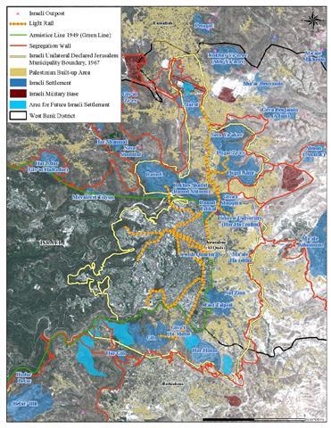
The Israeli transportation system is relatively new, and public transportation is considered relatively underdeveloped if to be compared to industrial countries but the bigger picture involves more comprehensive plans related to the overall Israeli endeavor to consolidate its grip on the land and to influence, meaning to tailor the prospects of the Palestinian state to be in its own interest and coherent to its plans. The settlement project in the occupied West Bank territory is a corner stone in the comprehensive Israeli project, and while it is valid to consider the needs of the people to facilitate accesses for them to major cities and workplaces; it will also be naïve to think that anything happens here is not politically related and to dismiss the concept that whatever Israel plans in relation to the occupied West Bank territory; particularly in occupied East Jerusalem is not related to its plans to grape as much possible land from the West Bank and Jerusalem to ultimately maneuver the peace process to its own course of plan.
To this end, the need for practical, purposeful, serviceable and well-designed public transportation network was more important than ever between Jerusalem as the center core of the settlement project in the West Bank and the major cities where industrial and businesses centers exist. Jerusalem has always been a vortex for the rest of the Israeli settlements in the West Bank and the point where the leave the occupied territory into Israel. More than that the success, in fact the durability of the settlement project in the West Bank became somehow associated with providing a swift and functional transportation system for the settlers between the settlements within Jerusalem and the outskirts of the occupied city to major cities to the settlers’ work areas.
The whole transportation system is an integrated one that aims to complement settlements, Jerusalem and Israel in the following phased scenario:
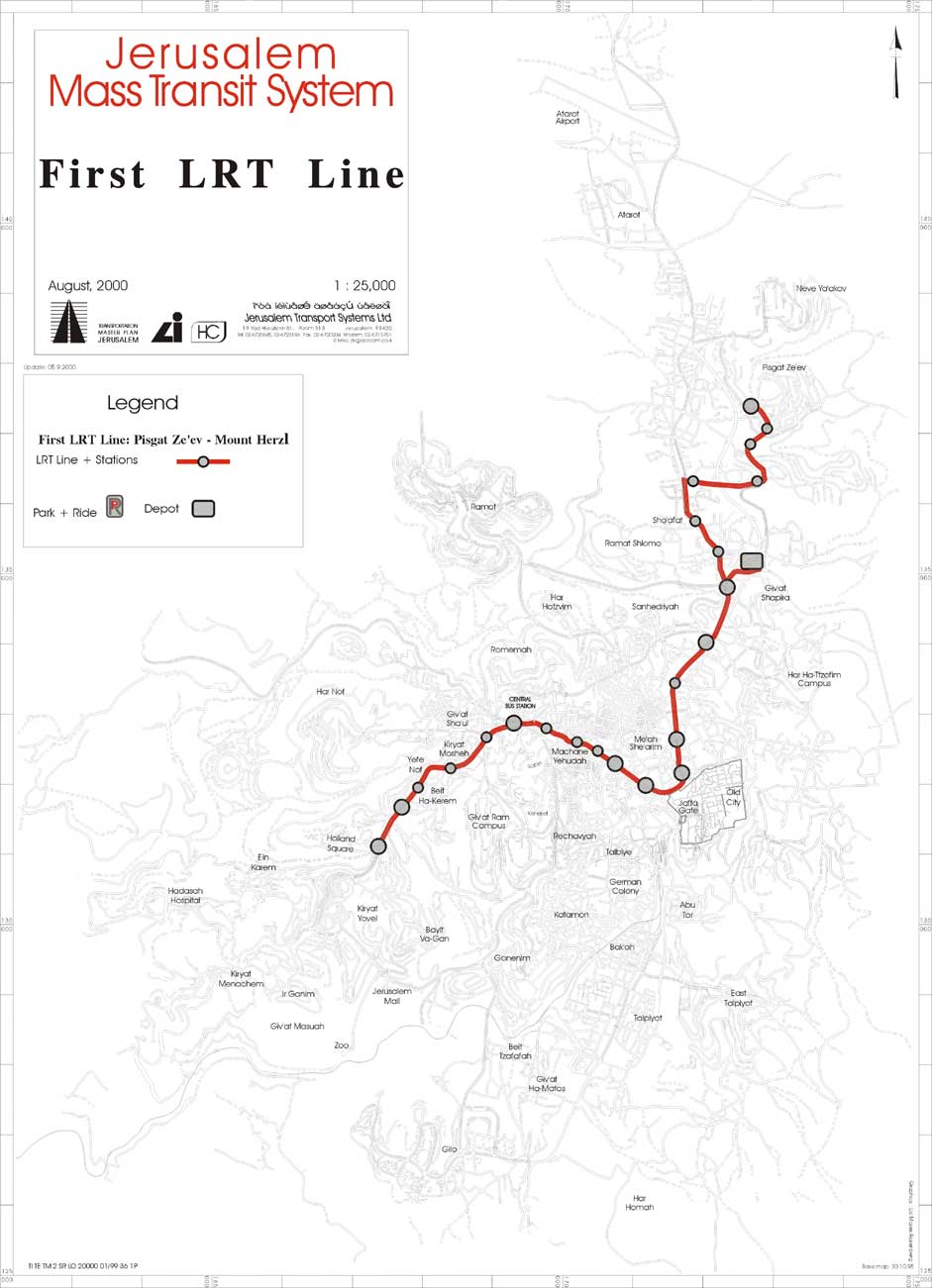
Phase One: Light Rail Track – Jerusalem
in 1999 the Israeli government approved a project to build a light rail that link settlements in East Jerusalem with each other and with West side of the occupied city. In 2005 the Israeli government contracted two French companies (Alstom, and Veolia) to implement the project. The track is set to link Pisgat Ze’ev settlement in occupied East Jerusalem with Herzl Mountain in West Jerusalem with a budget set at 1.7 billion NIS (515 USD) of which 1.2 billion NIS (364 USD) financed by the Israeli private sector.
The work on the light rail started in April 2006 and according to the plans set, the first phase of the project was set to complete by 2009 across 13.8 km with 23 stops and serving more than 100,000 Israeli settlers in settlements Neveh Yaccov, Pisgat Ze’ev, French Hill, and Ma’alot Dafna. Furthermore, the light rail plan have several other serving tracks to link Ramot settlement located northwest of Jerusalem with West Jerusalem and others linking south Jerusalem settlements such as Gilo settlement through East Talpiot settlement. See related Map 1, 2& 3


Phase Two: Fast Rail Tracks – Jerusalem – Tel Aviv
This ranging 55 km rail between Jerusalem and Tel Aviv has more than meets the eye as it tend to serve the Tel Aviv outskirts as well and every community between Tel Aviv and Jerusalem just the same. All in service of the ultimate goal, which to help to invigorate settlement program in the West Bank territory including – particularly- in occupied East Jerusalem. These high speed lines of tracks will be the first of its kind in Israel. It will reduce travelling time between the two cities to 28 minutes instead of 90 minutes that of the old track and was little used, in fact it will surpass the private and public highways travel between the cities, which often experience massive traffic jam.
The concept for this track emerged back in 1998 when the service track between Tel Aviv and Jerusalem was suspended for poor condition status, and beyond repair in terms of cost effectiveness. Accordingly, several alternative plans were put forward. In 2001, a plan was concluded to make minor repairs to the old track route and to construct new line/s between the main track and nearby cities/ communities. A subsidiary of Germany’s National rail operator “Deutsche Bahn” was appointed to re-evaluate the planned track.
Criticism of the planned track line revolved over two sections of the track line (6 km) where they pass through the West Bank, near Mevaseret Zion and Canada Park; and even though much of that distance run through tunnels it still runs through occupied territory hence, violates international law.
In all, the fast rail track between Jerusalem and Tel Aviv will facilitate movement of settlers from settlements in East Jerusalem and surrounding settlements’ blocks (Ma’ale Adumim, Giva’t Ze’ev, Gush Etzion, among other settlements) toward Tel Aviv and other industrial towns near Tel Aviv like Holon and Rishon Litzion,
Phase Three: the ARC plan
The ARC plan was introduced by an American corporation called RAND as an approach to build a viable Palestinian state. The word viable here specify geographical contiguity if the term apply to link the two entities that will form the Palestinian state together -the West Bank and the Gaza Strip- and facilitate the movement of Palestinians within the West Bank cities. The plan was prepared without taking the political aspects on the ground into consideration; or it may just consider the status-quo an inevitable reality that the Palestinians must deal with. In fact it does more than that and deals with the Segregation Wall, the settlements and the annexation of Jerusalem by Israel for granted. More than that it accommodate Israel’s control over the territory.
The ARC plan is basically intending to reroute the transportation system in the West Bank in harmony with the Israeli under construction Segregation Wall. Furthermore, it is intended reshape the physical structure of the West Bank eastward of the major urban city centers, away from the Segregation Wall. The ARC plan intends more than upgrading the transportation system in the West Bank but also creation of new urban centers along this new route. It even goes beyond that to allow inter-regional transportation contiguity with neighboring countries (Egypt, Syria, Lebanon, and Jordan) including Israel, in fact it will make it nearly impossible to exclude Israel from the regional transportation grid.
The ARC plan

Prepared by:
The Applied Research Institute – Jerusalem
The Applied Research Institute – Jerusalem