Violation: Dumping sewage and waste water into Palestinian agricultural lands.
Date: April 22nd, 2010.
Violator: The colonist of the colony of Etzion.
Affected: Sabarna family.
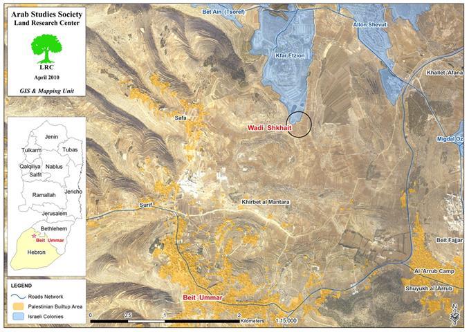
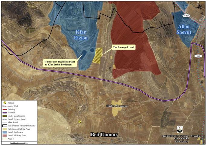
Location: Shakhiet Valley which is located northeast of the town of Beit Ummar in Hebron Governorate. The population of the town is 15,000. The town is famous for its agricultural products such as grapes, apples, almonds in addition to the different types of vegetables. The town is surrounded from all directions by Israeli-imposed restrictions; the colony of Kfar Etzion borders the town from the north while the colony of Karmi Tzur borders it from the south. In the east, a permanent Israeli occupation checkpoint is located at the entrance of the town while a fence encircles the town along by-pass Road 60.

Map.1: The location of the Shakhiet Valley – Beit Ummar.
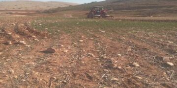
Details of Violation: On the 22nd of April, 2010 colonist from the colony of Etzion dumped sewage and waste water on Palestinian lands owned by Palestinians from the town of Beit Ummar. According to the Beit Ummar Municipality, the colonists purposely let the sewage flow from the sewage treatment unit located at the southern end of the colony which led to the drowning of 70 dunums of Palestinian lands with the flowing affluent and wastewater.
Photos 1+2: The sewage in Palestinian lands in Shakhiet Valley.
The affected lands are owned by 7 Palestinians from the clan of Sabarneh. The following table lists their names and relevant information:
|
No.
|
Name
|
Damage
|
Extent of Damage
|
|
1
|
Mohammad Saber Ismaeil Sabarneh
|
Increased the salinity of the soil + gradual spoilage of grape trees + the unsuitability of the product for human consumption.
|
Total
|
|
2
|
Khalil Saber Ismaeil Sabarneh
|
Total
|
|
3
|
Mustafa Saber Ismaeil Sabarneh
|
Total
|
|
4
|
Mohammad Oudeh Sabarneh
|
Partial
|
|
5
|
Ahmad Oudeh Sabarneh
|
Partial
|
|
6
|
Mahmoud Oudeh Sabarneh
|
Partial
|
|
7
|
Hamed Yousef Mahmoud Sabarneh
|
Partial
|
Kfar Etzion colonists have built in the early 1990’s a station to collect and treat the waste water and sewage produced in the colony. Treated water was, then, used to irrigate tens of agricultural dunums that were confiscated earlier.
Photo 3+4 : A general view of the colonists’ agricultural fields that is irrigated with treated wastewater

Photo 5: The pipes that carry wastewater running through Palestinian lands.
In regards to the damages that will become of the affected lands, a joint report between the Beit Ummar Municipality and Hebron Agricultural Directorate indicated that it is expected that the salinity of the soil will increase which would lead to the death of the trees in the targeted lands. Moreover, a report issued by the Beit Ummar Municipality estimated that the losses exceeded $100,000 in accordance with the following table:
|
Area in Dunum
|
Product
|
Production Rate (Kg/dunum)
|
Total Production (in Kg)
|
Price (NIS/Kg)
|
Total Price (NIS)
|
|
70
|
Grapes
|
1000
|
70,000
|
2
|
140,000
|
|
|
Grape leaves
|
500
|
35,000
|
7
|
245,000
|
It has to be kept in mind that Israeli occupation authorities intend to establish a fence surrounding the colony of Etzion. The Palestinian Liaison Office has informed the Beit Ummar Municipality that the Israeli side has informed it of its intention to do so in the near future. If such a plan is carried out, an additional 7,200 dunums of Beit Ummar will be annexed into the colony while an additional 800 dunums will be confiscated to build the fence atop it.

Photo 6: A general view of Shakhiet Valley.
The drowning of the lands is only an event in a series of attacks and violations carried out by the colonist of Etzion on Palestinian farmers and their lands. It’s been always the case that colonists chase after shepherds grazing with their sheep on their lands near the colony. That is in addition to letting gazelles roam freely on Palestinian lands especially during the grapes season which causes great economical damage to the trees.
Moreover, Israeli occupation forces had confiscated an entire mountain in July 2008 that is located on the western side of the Valley. These forces declared the mountain to be a ‘Closed Military Area” in an attempt to prevent members of Al Brighith family to access their lands in the said mountain. The total area of the mountain is between 70 and 80 dunums that are used for grazing and planting purposes.
Photo 7: An overview of the confiscated mountain.
Beit Ummar at a Glance:
The town of Beit Ummar is located 12 kilometers north of the city of Hebron. Its total area is 21,285 dunums of which 1,375 dunums are its built up area. Currently, there are 13,548 Palestinians living in the town.
Israeli occupation forces had confiscated 560.5 dunums in the past to be used for the establishment of By-Pass Road 60 while an additional 1,216 dunums were confiscated and used to establish the following colonies:
|
Colony
|
Establishment Date
|
Lands Confiscated in Dunums
|
Colony Built Up Area in Dunums
|
No. of Colonists
|
|
Karmi Tzur
|
1984
|
179
|
289
|
623
|
|
Migdal Oz
|
1977
|
682
|
1,076.4
|
298
|
|
Kfar Etzion
|
1976
|
18.6
|
923.5
|
404
|
|
Efrata
|
1979
|
98.6
|
2,063.6
|
7,037
|
|
Alon Shivot
|
1971
|
237.8
|
934
|
3,146
|
|
TOTAL
|
1216
|
5,286.5
|
11,508
|
Source: GIS Unit – Land Research Center.


