Violation: Military lands grab orders.
Date: April 15, 2010.
Violators: State Properties office (responsible for absentee properties)
Victims: ‘Anata residents.
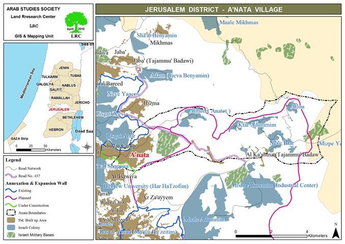
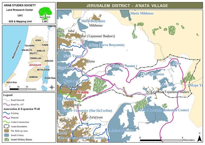
Location: ‘Anata is located 6 km to the north east of Jerusalem.
Population: 12049.
Area: 32240 dunums including 2082 dunums of built-up area.
Details: the Israeli Occupation Authorities sent tens of land grab orders, for lands in ‘Anata, using the ordinary mail. On April 15, 2010, tens of ‘Anata residents received notes signed by the state representative of the absentee properties, the note said: ‘We hereby inform you that the Israeli Army has taken over lands in parcels 5, 7, and 8 by the military order …’
The note also stated that the owners can refer to the ‘District Coordination Office’ in order to acquire information about possible compensations. It must be known that Israeli construction have been taking place in the area long before the confiscation orders were handed to the owners, who, in turn, reject any compensation and want nothing but their land. The Israelis claim that part of the expropriated land will be used for public good, the rest for military purposes.
Notes 1-4: photocopies of the military orders
‘Anata survival battle:
It is not the first time such land grabs take place. On January 28, 2010, the Israeli Occupation Authorities aimed to other parts in the same parcels and handed similar military orders. It must be known that constructions were being carried out on January 17, 11 days before handing the notes.
The Israeli Army laid his hands on 18000 dunums which were designated as state treasury property by the Jordanian Government before the Israeli conquest of the West Bank.
On October 7, 2009, lands grab orders were issued and notes were sent through mail informing the owners of the fate of their lands. The notes informed the landlords of the confiscation and that the land is to be used for military purposes.
On November 28, 2006, the Israeli Occupation Army expropriated 1828 dunums of ‘Anata lands by the military order 84/06/t. The total confiscated areas in ‘Anata are somewhere around 20822 dunums used for the Israeli military encampment, by-pass roads, segregation wall.
The Israeli Army is currently constructing a section of the wall around ‘Anata. The wall is expected to be 24 km long and isolate more than 17729 dunums. in addition, the section is built over 2400 dunums.
There is a number of Israeli Colonies around ‘Anata, they are:
|
colony
|
Establishment year
|
Built-up area
|
population
|
Over ‘Anata lands (dunums)
|
|
Mishur Adumim
|
1974
|
3219
|
N.A
|
83
|
|
Alon
|
1990
|
314
|
38992
|
314
|
|
Kfar Adumim
|
1979
|
817
|
1866
|
817
|
|
Neve Brat
|
1992
|
850
|
N.A
|
850
|
|
Almon
|
1983
|
787
|
726
|
786
|
|
Pizgat Ufar
|
1985
|
2477
|
N.A
|
7
|
|
Total
|
8464
|
41584
|
2857
|
*Source: GIS unit, LRC
LRC views such confiscations as a clear violation of Geneva Fourth Pack and the international laws that prohibit taking over the occupied lands for the sake of the occupier force no matter what the reason is.


