• About The Project
  • Palestine in Century
  • Selected Maps
  • Glossary
  • About ARIJ
  • About LRC
  • By Year
    • Case Studies By Year
    • Daily Report By Year
Saturday, May 10, 2025
POICA
No Result
View All Result
  • Home
  • Settlements
    • New Israeli Settlements
    • Settlement Expansion
  • Israeli Violations
    • Agriculture
    • Confiscation
    • Demolition
    • Environment
    • Eviction of Palestinians
    • Settlers Attacks
  • Bypass Roads
  • Israeli Plans
  • Segregation
    • Checkpoints
    • Closure
    • Separation Plans
  • Military Orders
  • Reports
    • Daily Report
    • Monthly Report
    • Quarterly Report
No Result
View All Result
POICA
No Result
View All Result

Israeli Occupation Devours More Land from Deir Sharaf to Establish a New Colonial Road

April 23, 2009
in Bypass Roads
Israeli Occupation Devours More Land from Deir Sharaf to Establish a New Colonial Road

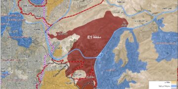
In synchronization with the removal of the Beit Iba checkpoint and replacing it with a new checkpoint 2 kilometers north of the old one, the commander of the occupation forces in the West Bank issued a military order on April 1st, 2009 that called for the confiscation of 10.9 dunums of the lands of the village of Deir Sharaf. The targeted lands, laying in Parcels 10 and 12 of the village, were confiscated for the purpose of the construction of a new colonial road connecting the colony of Shavi Shomron with By-Pass Road 60 (the main Tulkarem-Nablus Road). The length of the new road is 500 meters with a width of 30 and is considered to be an alternative to the colonial road that was established in 2004 (Photo 1) located only 30 meters from the proposed new road. The main goal of the construction of the new road is to relocate the main entrance of the colony of Shavi Shomron away from the Palestinian communities of Deir Sharaf and Sabastiya. See Map 1

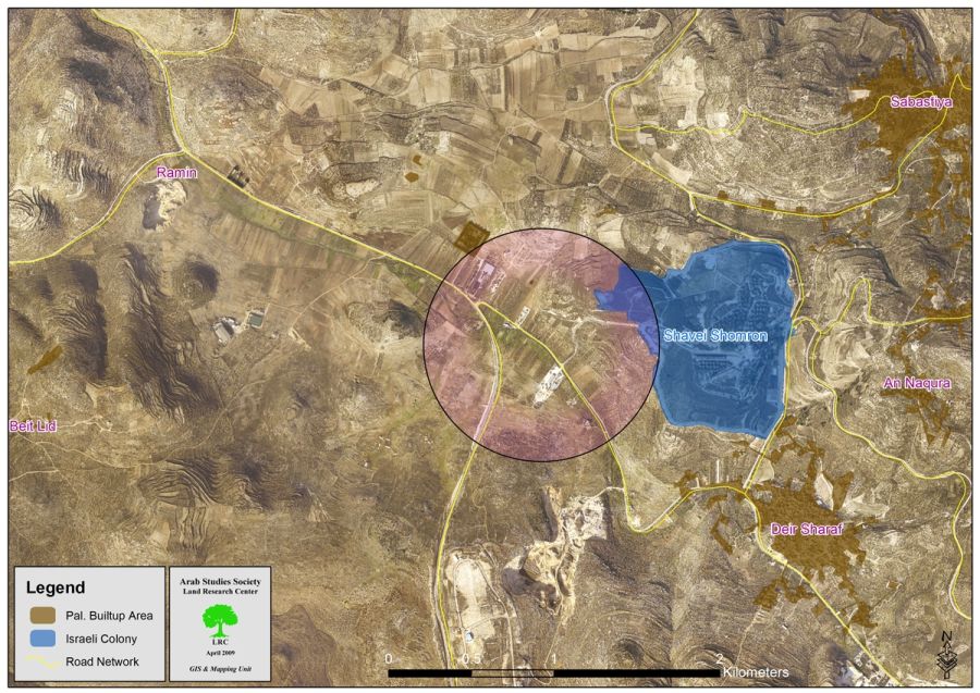
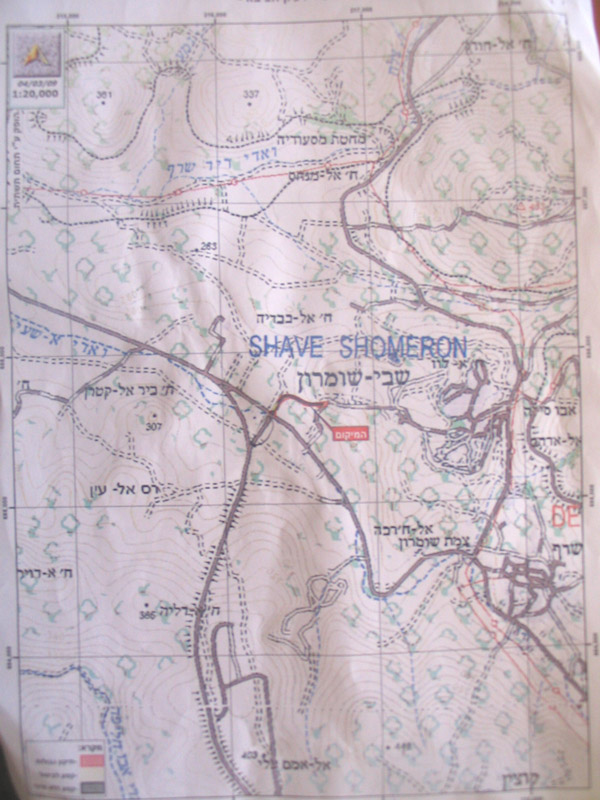
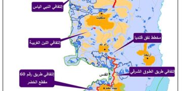
Israeli occupation authorities claim that the military order (carrying number T/182/05 as depicted in (Photo 2) was issued and distributed in 2005. In turn, the head of Deir Sharaf’s village council, Mr. Mohammad Halawa, denied receiving the order and considered it to be an additional step in stealing more Palestinian lands with total disregard for international laws and norms.

Shavi Shomron Colony: General Information

The colony is located atop lands used to be a Jordanian Army base 8 kilometers north of the city of Nablus. The lands belonged to the Palestinian villages of Sabastiya and Deir Sharaf. After the occupation of 1967, Israeli occupation forces overtook the base and transformed it to a military post. In 1977, colonial caravans started to be placed inside the military post to be used by colonists to reside in. Currently, the colony has expanded to include 2000 dunums of Parcels 10 and 6 of Deir Sharaf and Parcel 4 of Sabastiya lands. Currently, there are 631 colonists living in the colony. In 2005, Israeli occupation forces erected a fence surrounding the colony which led to the confiscation of hundreds of agricultural dunums beneath and beyond the fence.

Deir Sharaf: General Information

The village is located 9 kilometers northwest of the city of Nablus. The villages of Beit Leed and Ramin are located east of the village while the villages of Beit Iba, Al Naqoora and Qoseen surround the village from its western direction. The surface area of the village is 7190 dunums of which 132 dunums were declared as “State Lands” by Israeli occupation forces. The remaining area is registered with the Tabu and is officially owned by Palestinian farmers. Around 1000 dunums of the villages’ lands are used for colonial purposes atop which the colony of Shavi Shomron is established. The Built-up area for the village is 455 dunums while 3400 dunums are unused lands that are unsuitable for agricultural activities.

According to the latest 2008 PCBS figures, around 2900 Palestinian live in the village. About 40% of its workforce depends on agriculture as the main source of income. There are five main clans in the village including Al Hara, Al Antary, Nofal, Foqaha and Musa. That is in addition to a small number of refugee families that constitute 15% of the population of the village.

It is worth pointing out that the village has a water well from which 4,000 m3 of water are pumped daily to the nearby city of Nablus along with the village of Qoseen and other nearby villages.

Israeli Dump: The Most Dangerous Threat

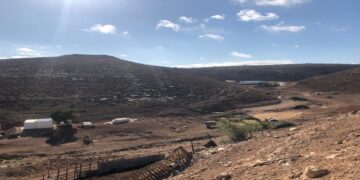
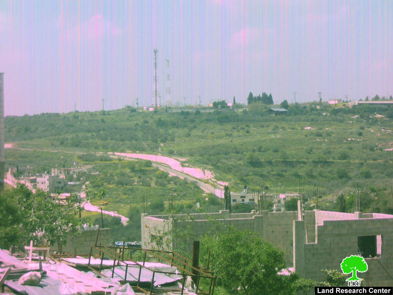
The village of Deir Sharaf is facing on daily basis the threat poised at it from the nearby waste dump in which Israeli factories used to dump its waste in it (Pic. 3 and 4). It is located only 500 meters away from the houses of the village. The area of the dump is 150 dunums and is located 300 meters away from the well which poses a danger of underground water contamination. The untreated chemicals thrown into the dump also threatens 5 additional smaller wells including Ein Kahel well, Nablus well (which provides water to the 150,000 residents of Nablus), 2 wells providing water to Deir Sharaf and 2 wells providing water to the 3,000 residents of Beit Iba. For additional information, please follow this link.  


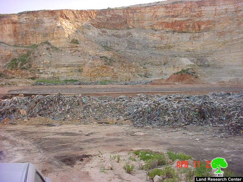
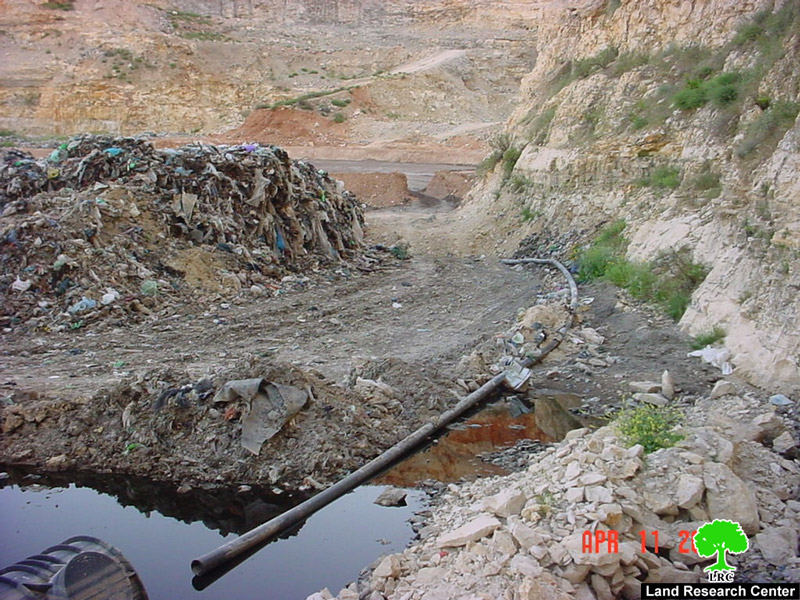
The dump was created in 2000 when Israeli occupation forces took advantage of the closures around the West Bank and overtook the quarry of Abu Shoosha located west of the village and transformed it into a waste dump. However, a sustained campaign by national and international organizations led to the suspension of dumping in the site. Nevertheless, the dumping restarted once again in the early 2009 and is forming a renewed danger on the health of Palestinians living in its vicinity and beyond.  


 Prepared by:
The Land Research Center
LRC


Recommended For You

شق طريق استيطاني جديد يهدد سبل العيش في قرية بردلة

by arij
January 13, 2025
0
New Israeli Settlement Road Construction and Its Impact on the Village of Bardala in the Jordan Valley

المكان: تجمع بردلة- محافظة طوباس/الأغوار الزمان: سبتمبر 2024 الجهة المتضررة: أهالي قرية بردلة والقرى المجاورة الجهة المعتدية: ما تسمى بالإدارة المدنية الاسرائيلية الانتهاك: شق طريق استيطاني تفاصيل الانتهاك:...

Read moreDetails

New Israeli Settlement Road Construction and Its Impact on the Village of Bardala in the Jordan Valley

by arij
December 31, 2024
0
New Israeli Settlement Road Construction and Its Impact on the Village of Bardala in the Jordan Valley

  The construction of new settlement infrastructure in the occupied Palestinian territories has profound implications for local communities, threatening livelihoods, increasing isolation, and impairing socio-economic vulnerabilities. This case...

Read moreDetails

الطرق الالتفافية الاسرائيلية وأثرها على البيئة الفلسطينية

by arij
January 16, 2024
0
الطرق الالتفافية الاسرائيلية وأثرها على البيئة الفلسطينية

  الاعتداءات الإسرائيلية على الفلسطينيين لا تقتصر على التنكيل بالافراد، أو وضع القيود على الحركة والتنقل، أو استهداف المنازل والمنشات، أو مصادرة الأراضي، أو نهب الموارد والمصادر الطبيعية،...

Read moreDetails

Israeli Colonists Take Over an Agricultural Road in Ya’bad town / Jenin Governorate

by arij
January 12, 2022
0
Israeli Colonists Take Over an Agricultural Road in Ya’bad town / Jenin Governorate

  Violation: Taking over an agricultural road for the favor of colonization. Location: Ya’bad town / Jenin Governorate. Date: October 17th 2021. Perpetrators: Mevo Dotan Colony. Victims: Farmers...

Read moreDetails

New Colonial road to Be Opened on Sarta Village lands / Salfit Governorate

by arij
July 17, 2021
0
New Colonial road to Be Opened on Sarta Village lands / Salfit Governorate

  Violation: Opening a new Colonial Roads. Location: Sarta village/ Salfit Governorate. Date: June 1st 2021. Perpetrators: The Israeli Illegal Industrial Colony (Barkan). Victims: Farmers from the village....

Read moreDetails
Next Post
التهام المزيد من الأراضي الفلسطينية لشق طريق استيطاني جديد في قرية دير شرف

التهام المزيد من الأراضي الفلسطينية لشق طريق استيطاني جديد في قرية دير شرف

LATEST NEWS

الأراضي الفلسطينية بين الذرائع الأمنية والأطماع الاستيطانية – “الأمن، الآثار، والطبيعة كحجج لاقتلاع الفلسطينيين من أراضيهم”

by arij
April 15, 2025
0

........................................................

الطرق الالتفافية الاسرائيلية وأثرها على البيئة الفلسطينية

انتهاك للطبيعة والهوية في الأراضي الفلسطينية المحتلة

by arij
March 17, 2025
0

........................................................

Israel Advances Settlement Plan on Ancient Olive Groves on lands of Beit Jala city, Violating International Law and depriving Palestinians their lands

إسرائيل تمضي قدمًا في مخطط استيطاني جديد على أراضي مدينة بيت جالا، في انتهاك للقانون الدولي وحرمان الفلسطينيين من أراضيهم

by arij
April 29, 2025
0

........................................................

Israel Advances Settlement Plan on Ancient Olive Groves on lands of Beit Jala city, Violating International Law and depriving Palestinians their lands

Israel Advances Settlement Plan on Ancient Olive Groves on lands of Beit Jala city, Violating International Law and depriving Palestinians their lands

by arij
April 29, 2025
0

........................................................

flag_yellow_lowEU-PfP-Logo

This website has been produced with the assistance of the European Union. The contents of this publication are the sole responsibility of ARIJ & LRC and can in no way be taken to reflect the views of the European Union.

© 2025 Copyright ARIJ . All Rights reserved. .

No Result
View All Result
  • Home
  • Settlements
    • New Israeli Settlements
    • Settlement Expansion
  • Israeli Violations
    • Agriculture
    • Confiscation
    • Demolition
    • Environment
    • Eviction of Palestinians
    • Settlers Attacks
  • Bypass Roads
  • Israeli Plans
  • Segregation
    • Checkpoints
    • Closure
    • Separation Plans
  • Military Orders
  • Reports
    • Daily Report
    • Monthly Report
    • Quarterly Report

© 2025 Copyright ARIJ . All Rights reserved. .