• About The Project
  • Palestine in Century
  • Selected Maps
  • Glossary
  • About ARIJ
  • About LRC
  • By Year
    • Case Studies By Year
    • Daily Report By Year
Friday, May 9, 2025
POICA
No Result
View All Result
  • Home
  • Settlements
    • New Israeli Settlements
    • Settlement Expansion
  • Israeli Violations
    • Agriculture
    • Confiscation
    • Demolition
    • Environment
    • Eviction of Palestinians
    • Settlers Attacks
  • Bypass Roads
  • Israeli Plans
  • Segregation
    • Checkpoints
    • Closure
    • Separation Plans
  • Military Orders
  • Reports
    • Daily Report
    • Monthly Report
    • Quarterly Report
No Result
View All Result
POICA
No Result
View All Result

The Initial Stages of Constructing the Israeli Segregation Wall in the Village of Arab Al Ramadien

January 5, 2009
in Segregation
The Initial Stages of Constructing the Israeli Segregation Wall in the Village of Arab Al Ramadien

Israeli occupation forces began the basic infrastructure work for the Racist Wall in the village of Arab Al Ramadien located south the Governorate of Hebron. The initiation of the work came on the heels of the Israeli occupation authorities’ declaration in February 2008 of confiscating hundreds of dunums belonging to the village and the towns of Adh Dhahiriya and Dura for the purpose of constructing the Racist Wall.


In Mid December, 2008 Israeli bulldozers arrived at Al Ramadien and started plowing the targeted lands as a prelude to the establishment of the Wall which is designed to annex the colony of Ashkolot as well as 4,000 dunums into Israel.


Photo 1 & Photo 2: Israeli bulldozers plowing Palestinian lands in Al Ramadien.


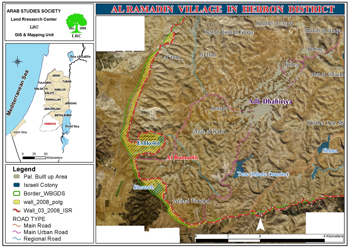
Al Ramadien residents indicated that Israeli occupation engineers came to the specified lands and placed marks with serial numbers as to function as a guide for the upcoming drilling and plowing in Palestinian lands for the purpose of establishing the Wall.


Photo 3 & Photo 4: The marks placed by Israeli occupation engineers for construction of the Wall.


The house of Mr. Suleiman Al Jama’een is the closest house in Al Ramadien to the colony of Ashkolot. He indicated the following to the Land Research Center (LRC)’s field researcher: ' The engineers of the occupation forces placed the marks in my land as a prelude to plowing it. The marks do not match the ones located in the previously-issued military order that confiscated the land in February, 2008. The engineers expanded the targeted areas in an effort to get the Wall as close as possible to our homes as to annex the largest pieces f land possible. '


He added that: '  When I tried to defend my land and stop this obvious land grab, the Israeli guards that came along with the engineers threw me out of my land. They have also released a police dog which attacked my camel which was grazing in my land. The camel sustained multiple injuries.'

Photo 5: The injuries sustained by the camel due to the dog attack


Upon the visit of LRC to the village of Al Ramadien, the Israeli bulldozers were witnessed plowing the lands under heavy protection from an Israeli private guarding company employed by the occupation forces.


Photo 6: An Israeli bulldozer plowing Palestinian lands in Al Ramadien,


In its implementation of the initial construction of the Wall, Israeli occupation forces worked on two axises: 

  • The first included starting the plowing from the eastern gate of the colony of Ashkolot and moving northwards towards what has become to be known as Wadi Al Tuff and Wadi Fattas. More than 1 kilometer has been plowed in the said area.

Photo 7: The lands that were plowed in Wadi Al Tuff and Fattas.


  • The second axis started from the eastern gate of the colony and headed southwards towards the Negev. Around 1.5 kilometers were plowed so far.

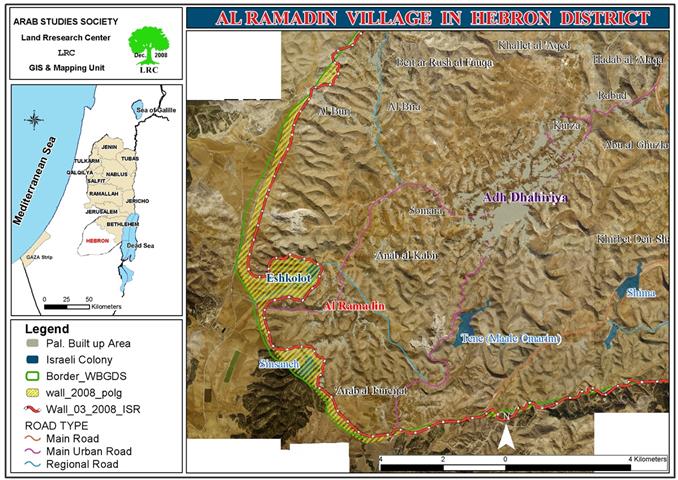
In case the construction is completed, it means the encirclement of the colony of Ashkolot as well as 4,000 dunums to be all annexed into Israel. The head of Al Ramadien village council, Mr. Younis Al Shour, affirmed the following to the LRC field researcher: ' Israeli occupation bulldozers did not abide by the issued maps. The engineer in the so-called Israeli “Civil Administration” came earlier to the village and showed up the proposed route of the Wall. The route taken by the Israeli bulldozers does not match that shown to us by the Administration.'


He also pointed out that: ' Since the occupation issued its decision to confiscate the lands here, we have filed a legal petition against it. A lawyer was hired in addition to addressing a number of national and international rights organizations. However, the lawyer, Mr. Ghayyath Naser, informed us lately that the Court has rejected our appeal.'    


As for the nature of the Wall in the targeted area, it is expected that it will be made of a series of barbwires supplied with motion sensors. The new setup will be joined with the all ready existing Wall in the area.


Upon the completion of this section of the Wall, Israeli occupation forces would have totally and completely encircled the village of Al Ramadien. Such encirclement would have a negative impact on the livelihood and well being of Al Ramadien residents. For additional information on this topic, please refer to LRC’s case study in this regard on the following web link: http://www.lrcj.org/Arabic/ViolationsMonitoring/Cases/ASHKOLOT/ASHKOLOT.htm


 Prepared by:
The Land Research Center
LRC

Recommended For You

سلطات الاحتلال الإسرائيلي تفرض واقعا جيوسياسيا جديدا في منطقة شمال قطاع غزة المحتل

by arij
March 13, 2024
0
سلطات الاحتلال الإسرائيلي تفرض واقعا جيوسياسيا جديدا في منطقة شمال قطاع غزة المحتل

  أظهرت صور الأقمار الصناعية الصادرة عن برنامج مراقبة الأرض التابع للاتحاد الأوروبي (كوبرنيكوس) لقطاع غزة المحتل في العاشر من شهر اذار من العام 2024، ان سلطات الاحتلال...

Read moreDetails

الحرب على قطاع غزة وتأثيرها على محافظة الخليل جنوب الضفة الغربية

by arij
November 30, 2023
0

  تقع محافظة الخليل في الجزء الجنوبي من الضفة الغربية المحتلة، إلى الجنوب من مدينة القدس، وعلى بعد حوالي 36 كم منها. يحدها من الشمال محافظة بيت لحم،...

Read moreDetails

تطبيق سياسة الفصل العنصري على استخدام الطرق الرئيسية في الضفة الغربية وتقيد حركة وتنقل المواطنين الفلسطينيين

by arij
November 22, 2023
0
معاناة شجرة الزيتون الفلسطينية بسبب الاحتلال والاستيطان في العام 2023

  بناء على تقديرات مراقبين دوليين يبلغ عدد الحواجز الإسرائيلية في الضفة الغربية أكثر من 567 حاجز إسرائيلي متعددة الاشكال منها 77 حاجزًا رئيسيًا وجزئي تتحكم في حركة...

Read moreDetails

The Instigation of Apartheid Roads Era: Israel blocks Palestinian movement inside West Bank Governorates

by arij
November 22, 2023
0

  According to international observers, Israel constrains the West Bank territory with 567 various types of obstacles; 77 of which are main checkpoints and partial checkpoints that control...

Read moreDetails

Between “Ben Gavir” and Netanyahu Not Oblivious but Vindictive, The reality of Israeli Apartheid Stands in the occupied Palestinian territory

by arij
September 13, 2023
0
Between “Ben Gavir” and Netanyahu Not Oblivious but Vindictive, The reality of Israeli Apartheid Stands in the occupied Palestinian territory

  In the wake of the overwhelming Israeli settlers and the Israeli occupation government increasing their wave of attacks and assaults on the Palestinian people (more than 700...

Read moreDetails
Next Post
البدء بإقامة جدار الضم والتوسع العنصري في عرب الرماضين جنوب مدينة الخليل

البدء بإقامة جدار الضم والتوسع العنصري في عرب الرماضين جنوب مدينة الخليل

LATEST NEWS

الأراضي الفلسطينية بين الذرائع الأمنية والأطماع الاستيطانية – “الأمن، الآثار، والطبيعة كحجج لاقتلاع الفلسطينيين من أراضيهم”

by arij
April 15, 2025
0

........................................................

الطرق الالتفافية الاسرائيلية وأثرها على البيئة الفلسطينية

انتهاك للطبيعة والهوية في الأراضي الفلسطينية المحتلة

by arij
March 17, 2025
0

........................................................

Israel Advances Settlement Plan on Ancient Olive Groves on lands of Beit Jala city, Violating International Law and depriving Palestinians their lands

إسرائيل تمضي قدمًا في مخطط استيطاني جديد على أراضي مدينة بيت جالا، في انتهاك للقانون الدولي وحرمان الفلسطينيين من أراضيهم

by arij
April 29, 2025
0

........................................................

Israel Advances Settlement Plan on Ancient Olive Groves on lands of Beit Jala city, Violating International Law and depriving Palestinians their lands

Israel Advances Settlement Plan on Ancient Olive Groves on lands of Beit Jala city, Violating International Law and depriving Palestinians their lands

by arij
April 29, 2025
0

........................................................

flag_yellow_lowEU-PfP-Logo

This website has been produced with the assistance of the European Union. The contents of this publication are the sole responsibility of ARIJ & LRC and can in no way be taken to reflect the views of the European Union.

© 2025 Copyright ARIJ . All Rights reserved. .

No Result
View All Result
  • Home
  • Settlements
    • New Israeli Settlements
    • Settlement Expansion
  • Israeli Violations
    • Agriculture
    • Confiscation
    • Demolition
    • Environment
    • Eviction of Palestinians
    • Settlers Attacks
  • Bypass Roads
  • Israeli Plans
  • Segregation
    • Checkpoints
    • Closure
    • Separation Plans
  • Military Orders
  • Reports
    • Daily Report
    • Monthly Report
    • Quarterly Report

© 2025 Copyright ARIJ . All Rights reserved. .