• About The Project
  • Palestine in Century
  • Selected Maps
  • Glossary
  • About ARIJ
  • About LRC
  • By Year
    • Case Studies By Year
    • Daily Report By Year
Wednesday, October 15, 2025
POICA
No Result
View All Result
  • Home
  • Settlements
    • New Israeli Settlements
    • Settlement Expansion
  • Israeli Violations
    • Agriculture
    • Confiscation
    • Demolition
    • Environment
    • Eviction of Palestinians
    • Settlers Attacks
  • Bypass Roads
  • Israeli Plans
  • Segregation
    • Checkpoints
    • Closure
    • Separation Plans
  • Military Orders
  • Reports
    • Daily Report
    • Monthly Report
    • Quarterly Report
No Result
View All Result
POICA
No Result
View All Result

Israel continue to target the Palestinian Yatta Town time and again

July 18, 2008
in Military Orders


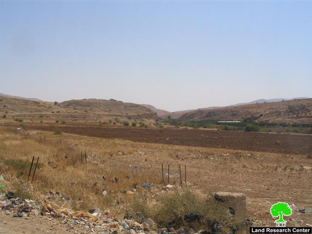
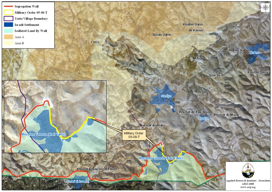
On July 17, 2008, the Israeli Army issued an official confiscation order holding number (MO 08-05-T) to build a part section of the Israeli Segregation Wall south of the Palestinian Yatta town. The order declared the confiscation of 22 Dunums; however, according to the analysis done by the GIS department at the Applied Research Institute-Jerusalem (ARIJ) of the maps delivered with the Israeli military order, shows that the total confiscated land included in this military order is 33 Dunums. More than that the construction of this part section of the Segregation Wall will ensure that the illegal Israeli settlement Mezadot Yehuda (Beit Yattir) is included within fully Israeli controlled territory. See Map 1


In addition to more than 2575 Dunums confiscated from Yatta’s land for the construction of the Segregation Wall since the year 2005, Israel’s hidden intentions of the Wall purpose became more and more evident that it exceeds the so-called and claimed security purposes of the Wall construction but more land grab, settlements’ expansion, a perception that was noted by the Mideast Quartet in My 2008 when it expressed its concern over Israeli settlements irregular activities in the West Bank.

About Yatta

Yatta is a Palestinian Arab city located within the governorate of Hebron, south of Hebron city, north to Negev Desert.  Prior to the 1948 war, Yatta total land area comprised 163.5 Km2. however, when Israel overshot the 1947 partition plan and occupied more land area than it was designated; more than 26% (43.5 Km2) of Yatta’s land were snatched toward Israeli controlled territory. Today Yatta spread on 120.7 Km2 (73.4% of its original area). It has a total population of 62,234 including the villages of Yatta area according to the Palestinian Central Bureau of Statistics in the mid of 2006.

Yatta within the Political Context

The Oslo II Interim Agreement signed in September 1995 between the Palestinian Liberation Organization (PLO) and Israel, concluded the occupied Palestinian Territory to come under 3 different types of classifications (Areas “A,” “B” and “C”) designating varying levels of control. Such classification was also assumed for the Palestinian Governorates, towns, and villages. Consequently, every Palestinian community, including Yatta became disrupted and; physically separated from each other. Under the signed agreement, Yatta was fragmented to areas “A,” “B” and “C.” Table 1 illustrates the areas distribution with population distribution. See table 1.

Table 1: The Geopolitical Divisions on Yatta Town according
to Oslo II Interim Agreement of 1995 

Area

Area in Km2

Number of

Localities

Area A

39..3

9

Area B

11.8

3

Area C

68.9

5

Nature Reserve

0.7

–

TOTAL

120.7

17

 Source: ARIJ GIS Database 2008

Yatta has its share of the Israeli settlements program. Over the past four decades of Israeli occupation, four Israeli settlements were established on private Palestinian lands confiscate from Yatta’s residents (see table 2). These Israeli settlements (population 1,838) sets today on a land area (7909 Dunums) almost equal the entire Palestinian built-up area of Yatta (8473 Dunums) where some 62,000+ Palestinian reside. Moreover, Yatta is clinched with more than 40 earth mound barriers, more than 15 road blokes, 8 road gates, 3 observation towers and one partial checkpoint that control and limits the freedom of movement for the population. See Table 2: Israeli Settlements established on Yatta Town lands 

SettlementName Pop.2006 Date Area inDunums
Karmel 357 1981 1831
Susiya 700 1983

5224

Mezadot Yehuda (Beit Yattir) 431 1977
Ma'on 350 1980 854
Total 1838   7909


Israel is still resilient to its position with regard to the Segregation Wall in spite of all international calls for it to stop the construction and make reparation for all occurred damages. The landmark decision of the International Court of Justice (ICJ) that condemned this act of 'Demographic Separation' went with apathy by Israel, which yet continues to build the Segregation Wall confiscating and demolishing Palestinian property.

The ICJ called upon the Israeli government to remove the wall and compensated the Arab residents for any damage done: 'The Court finds that the construction by Israel of a wall in the Occupied Palestinian Territory and its associated régime are contrary to international law'.

 :::::::::::::_

[1]: Areas Definition in Oslo II Interim Agreement of September 1995

  • Area A: The Israeli army has pulled out fully and Palestinians hold all responsibilities for internal security and Public order.

  • Area B:

  • Palestinians have full control over the civil administration; Israel continues to have overriding responsibility for security.

  • Area C:

The Palestinians have responsibility for civil life such as economics, health, and education; while, Israel retains full control over security and administration related to the territory.

[2] Susiya and Mezadot Yehuda (Beit Yattir) are joined in one master plan area


Prepared by:
The Applied Research Institute – Jerusalem

Recommended For You

ما يزيد عن 1900 دونما من الأراضي الفلسطينية في بيت لحم مهددة بالعزل لصالح مستوطنة افراتا

by arij
October 8, 2025
0
ما يزيد عن 1900 دونما من الأراضي الفلسطينية في بيت لحم مهددة بالعزل لصالح مستوطنة افراتا

في الثاني من شهر تشرين أول من العام 2025، أصدرت سلطات الاحتلال الإسرائيلي أمرًا عسكريًا جديدًا يحمل الرقم (ت/3/25) تحت عنوان "تعديل حدود – يهودا والسامرة، 5785-2025". ويأتي...

Read moreDetails

سلطات الاحتلال الإسرائيلي تستغل ‘المنفعة العامة’ لنهب الموارد الفلسطينية

by arij
September 30, 2025
0
سلطات الاحتلال الإسرائيلي تستغل ‘المنفعة العامة’ لنهب الموارد الفلسطينية

في الاول من شهر ايلول من العام 2025، نشرت الإدارة المدنية الإسرائيلية، الذراع الأيمن لحكومة الاحتلال الإسرائيلي أمرا عسكريا جديدا تحت عنوان " أمر ءبشأن قانون الأراضي (الاستملاك...

Read moreDetails

The Occupation Targets the Village of Raba Southeast of Jenin with Military Orders and Seizes Vast Areas of Its Lands

by arij
September 13, 2025
0
الاحتلال يستهدف بأوامر عسكرية قرية رابا جنوب شرق جنين ويصادر مساحات واسعة من أراضيها

 The Israeli occupation Army have continued their policy of plundering Palestinian lands, as their bulldozers leveled wide areas of agricultural land in the village of Raba, southeast of...

Read moreDetails

الاحتلال يستهدف بأوامر عسكرية قرية رابا جنوب شرق جنين ويصادر مساحات واسعة من أراضيها

by arij
September 13, 2025
0
الاحتلال يستهدف بأوامر عسكرية قرية رابا جنوب شرق جنين ويصادر مساحات واسعة من أراضيها

  واصلت قوات الاحتلال الإسرائيلي سياسة نهب الأراضي الفلسطينية، حيث أقدمت آلياتها على تجريف أراض زراعية واسعة في قرية رابا جنوب شرق محافظة جنين، تمهيدا لشق شارع عسكري...

Read moreDetails

Nablus Governorate’s Archaeological Sites Face Israeli Expropriation Plans

by arij
September 11, 2025
0
” المواقع الأثرية في محافظة نابلس… ساحة مفتوحة أمام مخططات المصادرة الإسرائيلية “

On 10 August, 2025, the Israeli Civil Administration (ICA), issued a booklet of military orders signed by the head of the so-called ‘Israeli Civil Administration’ in the occupied...

Read moreDetails
Next Post
Confiscation of 356 Dunums in Northern Jordan Valley

Confiscation of 356 Dunums in Northern Jordan Valley

LATEST NEWS

Annexation of the Jordan Valley: Implications for the Two-State Solution and Regional Stability

الرئاسة الثانية لترامب: فرصة متجددة لطموحات إسرائيل التوسعية – ضم غور الأردن والتداعيات على حل الدولتين واستقرار المنطقة

by arij
October 14, 2025
0

........................................................

محافظة أريحا على خريطة المصادرة الإسرائيلية- إسرائيل تسعى للاستحواذ على أكثر من 7000 دونم في منطقة النبي موسى

محافظة أريحا على خريطة المصادرة الإسرائيلية- إسرائيل تسعى للاستحواذ على أكثر من 7000 دونم في منطقة النبي موسى

by arij
October 13, 2025
0

........................................................

ما يزيد عن 1900 دونما من الأراضي الفلسطينية في بيت لحم مهددة بالعزل لصالح مستوطنة افراتا

ما يزيد عن 1900 دونما من الأراضي الفلسطينية في بيت لحم مهددة بالعزل لصالح مستوطنة افراتا

by arij
October 8, 2025
0

........................................................

Annexation of the Jordan Valley: Implications for the Two-State Solution and Regional Stability

Annexation of the Jordan Valley: Implications for the Two-State Solution and Regional Stability

by arij
September 29, 2025
0

........................................................

flag_yellow_lowEU-PfP-Logo

This website and its content were initiated in 1993 by the Applied Research Institute – Jerusalem (ARIJ) and the Land Research Center (LRC) with the support from the European Union up until 2023. Since then, the Applied Research Institute – Jerusalem (ARIJ) has taken over the continued development and maintenance of the website. The views expressed remain solely those of ARIJ) and do not necessarily reflect those of the European Union.

© 2025 Copyright ARIJ . All Rights reserved. .

No Result
View All Result
  • Home
  • Settlements
    • New Israeli Settlements
    • Settlement Expansion
  • Israeli Violations
    • Agriculture
    • Confiscation
    • Demolition
    • Environment
    • Eviction of Palestinians
    • Settlers Attacks
  • Bypass Roads
  • Israeli Plans
  • Segregation
    • Checkpoints
    • Closure
    • Separation Plans
  • Military Orders
  • Reports
    • Daily Report
    • Monthly Report
    • Quarterly Report

© 2025 Copyright ARIJ . All Rights reserved. .